
Friday 16th July 140 miles
We were awake early to a sunny morning. We drove on across flat land to Monte Vista, stopping at a little roadside park, sitting under cottonwood trees. We drove on through Del Norte, then at South Fork we followed the Silver Thread Scenic Byway, travelling north east at first. We were soon into National Forest, and were following the Rio Grande. We pulled in beside it for lunch – a group of rafters were just returning and other people were fishing or paddling, but then it began to rain! Unlike other days, the rain continued, and the rest of the day was very erratic.
We were now in lovely mountainous country, and drove through the former silver mining town of Creede, making us think of Creel in Mexico.
As the storm raged, we pulled in and didn’t leave until 4 o’clock.
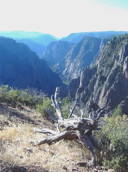
We soon stopped by Brown Lakes, the headwaters of the Rio Grande. We realised that we have seen the Rio Grande almost from its source to its mouth, at various places.
A bit further on we stopped by North Clear Creek Falls, which looked pretty good.
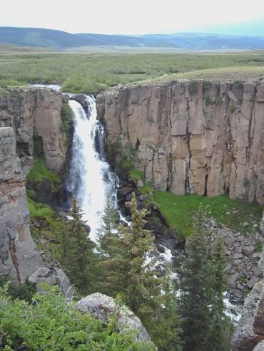
North Clear Creek falls
We soon came to Spring Creek Pass (10,898ft). This was the continental divide, with the Rio Grande flowing one way and the Colorado River the other. On from here was Slumgullion Pass (what a name! 11,530ft). Now it was down and down to Lake City, which might have looked better in the sunshine! An unmade road led eastwards from here to Silverton, where we were on Sunday.
We continued north, following the very pretty Gunnison River, but by now we needed somewhere to stop for the night, and nowhere was forthcoming. At one point several deer including a baby one, ran by and across the road. It was still very grey when we finally pulled into a little campsite called ‘The Gate’ beside the river at 6 o’clock.
Saturday 17th July 100 miles
It was cloudy when we woke, but the sun tried to chase the clouds away as it came up over the mountain. However, it was cool, but still lovely, when we left at 8.40. As we drove northwards, the cloud suddenly lifted, and we had blue sky as we drove through deserted hills covered in low sagebrush to Blue Mesa Reservoir in what is called Curecanti National Recreation Area.
We pulled into a rest area, where it was beautifully quiet, with just the sound of birds and ground squirrels. At Dry Creek, swifts had made numerous mud nests under the roof of the covered picnic table. There were herons at the water’s edge. We called into the Visitors Centre to collect some leaflets, then looked through them as we had coffee at East Elk Creek.
We drove over the bridge to the south side and had more viewpoints, the first to Dillons Pinnacles, but soon we left the reserve to drive several miles over Blue Mesa summit and then on to Black Canyon of the Gunnison National Park.
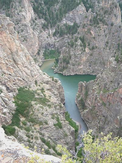
We first went to the South Rim campsite and found ourselves a place, before having lunch sitting outside under our awning (out of the sun!). We now drove along the South Rim, stopping at most of the viewpoints (of varying walking length) to view this fantastic gorge which was up to 2,700 ft deep, with sheer vertical sides. Far down below was the tumbling Gunnison River.
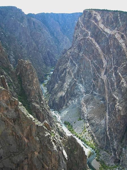
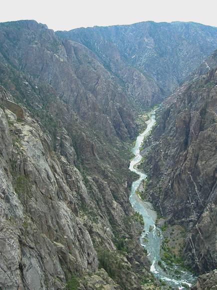
Black Canyon of the Gunnison
We drove to the far end, before returning to the Visitors Centre, where we watched a most impressive video which showed how a railway had been built in the canyon, and later a tunnel driven through the mountain for 6 miles to use the river for irrigation.
We walked to one last viewpoint here, Gunnison Point, before returning to the campsite. Here we lit the barbie. The skies cleared, so the stars were great at bedtime.
Sunday 18th July 102 miles
It was a lovely morning as we left at 7.15 to walk the Rim Rock Trail along the rim of the canyon. It was beautiful being out in the quiet early morning, and the views to the canyon were superb.
We were well ready for our breakfast when we returned at 8.15, but it was already hot in the sun.
We now left to drive down East Portal Road. This road wound right down to the river, and vehicles longer than ours weren’t allowed on it. It was very steep (2500ft in 3miles), with lots of bends, but the Bam coped fine! We came down to the site where a hundred years ago a 6 mile long tunnel had been bored through the mountainside to take water from the Gunnison River to irrigate the surrounding land. Just on from here was Crystal Dam, but we couldn’t get very close to it. We drove back up the winding road and left the park – by now it was 10.30.
We now had to drive back over Cerro Summit to Cimarron. This was back into Curecanti Recreation area. A road followed the Cimarron River down to the canyon to yet another dam, the Morrow Dam. In the 1880s, a railway had been built where this road now goes, and back along the main canyon (nearly all now under water!). We had seen a sign saying ‘Railway Exhibit’, but were surprised to find a delightful steam engine set high on its trestle bridge between the steep cliff sides!
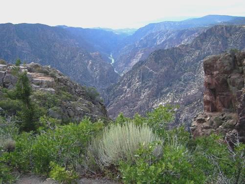
After much viewing of the engine and the dam, we drove back up the road and continued over Blue Mesa Summit and down to Lake Fork. Here we crossed to the north side by driving over the Blue Mesa Dam. We stopped here to view, and then stopped several more times as we drove along to Curecanti viewpoint.
Curecanti Viewpoint
A lady came up as we arrived and asked about our van – I invited her in to have a look. We ate lunch in the Bam before walking off to the overlooks. While enjoying the view down into the canyon we got chatting to another delightful couple – Tom and Susan. They live in Colorado Springs, but had never been here before. Susan had travelled to England 3 years ago as part of a singing group. Tom was also well travelled, and both were very enlightened people, so we enjoyed a vibrant conversation. Susan had a son of 24 who had been blind since a teenager, but was a real goer, and had travelled to Britain and Europe. She also had a daughter, and had recently become a grandmother. By the time we left them, it was 3 o’clock. We continued on our way, stopping at more places to admire the views. At Hermits Rest we could see down to Morrow Reservoir, as this part of the canyon is called, and to the San Juan Mountains in the distance. There were about a dozen little chipmunks entertaining the tourists.
We were now leaving Curecanti, although an unsurfaced road leads from Crawford, which we soon reached, to the North Rim of the Black Canyon. We had really enjoyed this whole area. We continued through Crawford, which looked an attractive little town full of character. There was a small reservoir here, but entrance was via the State Park, which charged $12 for camping on top of $5 for entrance, so we carried on a bit further and stopped beside the road at 5 o’clock.
Monday 19th July 160 miles
A day with several difficulties and disappointments, but also one or two pleasant surprises!
I had woken early with bad cramp in my leg, and found it difficult to put my foot to the ground for much of the morning. We left our spot soon after 8 o’clock, on a lovely morning, and just after Hotchkiss we pulled in to read a board about the Dominguez-Escalante expedition, which had come this way. The roadside was pretty with blue chicory, and this valley, the North Fork of the Gunnison, was very lovely.
The road now followed the valley, along with the river and the railway. The country was lovely, but we were surprised to pass through two small coalmining towns, Bowie and Somerset.
We went over the McClure Pass, with forested mountain slopes all around – aspens and firs, and with some snow in the crevasses, all very beautiful.
At suitably named Redstone we stopped to look at a whole line of strange beehive shaped brick coke ovens. We were now following the pretty Crystal River, and stopped to have our coffee sitting on the river bank.
We were surprised by the appearance of a large dog, but the owner, a lady from Toronto, soon got chatting to Adrian. They were staying in a nearby campsite and had come for a 3 week holiday.
We now came to Carbondale, with red cliffs to match Sidmouth! We turned south towards Aspen. The valley here was beginning to be occupied by estates of smart houses. We were heading for Snowmass, as Adrian had found out some information on the web about a memorial here to John Denver. He had set up an environmental project in the 70s, under the name of Windstar. We had trouble in finding it, particularly as there were roadworks at this point. Adrian went and asked at the tiny post office, and we were directed a couple of miles off the road to the conservation site.
The project would now seem to be combined with 2 other organisations, and we found it all to be rather strange. Our eyes immediately caught sight of a large statue of John holding an eagle.
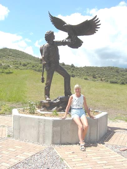
That seemed very fitting, but first we went into a building, following a sign saying ‘John Denver display’. This amounted to no more than a few photos and a couple of embroidered poems. There were people around, but nobody spoke to us until a lady named Holly came out from a small meeting and asked us if we had walked to the meditation platform. She directed us to it, and with the aid of my hiking stick (my leg now slightly improved), we were able to climb up the small hill and look down on this area of natural beauty. There was a 2 mile trail you could walk, but I wasn’t up to that right now!
We found the whole set up very strange. The place looked overgrown and unloved to us, rather than just natural. Around the statue were bricks with inscriptions from John’s friends and supporters. Some had just names on them, others had relevant lines from his songs, and some had moving messages. A nearby wooden carving of a dolphin looked as though it needed some attention.
All in all, we returned rather disappointed to the Bam, and ate our lunch listening to a tape of John Denver’s music.
We now followed some directions Adrian had got from the web to Starwood in Aspen, where John Denver had lived for many years, and wrote a lovely song about. We managed to negotiate a rather winding route into the hills, but then we came to a patrolled barrier saying ‘private’. Looking up, we could see a house which looked just like I had expected to see, but the security guard wasn’t going to let us in, so we had to turn round, stopping to take one or two photos of the views on the way down.
We drove on into Aspen, and despite it looking the wealthy town we had imagined, we had to agree that it was rather attractive, with flowers and trees everywhere (aspens of course, and firs). We pulled in in front of one house and amazingly found that the computer logged in! We were disappointed though, that we had hardly any messages. It was good to hear from Hil that she had visited Elm Gable and that all was well, but we had no replies to our recent email and website. We wondered if anyone had read them.
We now headed out towards Independence Pass, driving first through a whole forest of aspens, which we stopped to photograph.
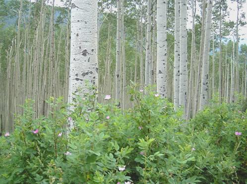
Aspens
The scenery was stunning – we stopped again and admired the wild flowers and then we came to the old ghost gold mining town of Independence. There were log cabins in various states of repair, set amongst carpets of wild flowers, with mountain streams cascading down the mountainside. The miners would not have had the chance to appreciate the beauty as we could. Also, it was unexpectedly and beautifully warm.
We continued to the pass, at just over 12,000ft. This was also the Continental Divide, and little trails had been formed so that people could appreciate the views and the wonderful flowers. Here it was much chillier, and we resorted to wearing trousers! It was alpine tundra, and there were ponds of water surrounded by grass and flowers. Snow was in many of the mountain crevasses.
Alpine sunflowers
It was now time to descend, but the forest we were driving through here didn’t welcome ‘dispersed’ camping, and all the campsites we tried cost $12. We stopped briefly by Twin Lakes, apparently a resort dating from the late 1800s, but we soon joined the busy road north. This was again following the river and the railway, in the valley, so there was nowhere to pull off. Eventually, at 6.15, we found a large parking area for a recreation site (fishing), and pulled in. The sky all around was very grey and threatening but the sun managed to shine from the one bit of blue.
Tuesday 20th July 85 miles
It was a fine morning. We walked up the steps to the fish-stocked artificial lake before leaving at 8.45. We drove through an area much poorer than Aspen, just over the mountain! We soon came toLeadville, noticing coal deposits beside the road, but Leadville had been a gold and silver mining town in the past. It is supposed to be the highest (incorporated) town in U.S. at 10,200ft. We drove through the old part, which had some really atmospheric old buildings, and then came to the ‘useful’ part – a Safeway and a laundrette! We did shopping and washing and tried once more unsuccessfully to phone Emma.
We now ascended the Fremont Pass, 11,000ft, to a place called Climax, which just seemed to be a mining concern (Molybdenum), and then drove down to the winter ski resort of Frisco. Like Aspen, we had to admit that it was very pleasant!
We had come into the town as we wanted to get my photos printed in Walmart. With our usual good luck, the man in front of us was using the machine to edit his 150 plus photos, and when he got to the end, he pressed the wrong button and had to do them all again! We waited over half an hour, but fortunately when we did get ours back, we were pleased with them. While they were being done, we ate our lunch in the Bam at the precinct opposite, and found that the computer logged in, but sadly there were no messages. We got some petrol, collected the photos, then set off again on the motorway (no alternative road here), ascending to the mile long Eisenhower tunnel (fortunately well lit!) at 11,200ft.
We now descended 2500ft (on a motorway!) to Silver Plume, where we hoped to ride the ‘Georgetown Loop’. This is another steam railway (the second in 5 days!). A steam engine pulls the carriages for a total distance of about 4 miles, although the actual distance between stations is only just over a mile. The difference in height though is 650ft, so the line has to zigzag back and forth and over itself. We arrived at 2.45, and the only trip left today departed at 3.45, so that gave us time to look through the photos before getting ourselves organised.
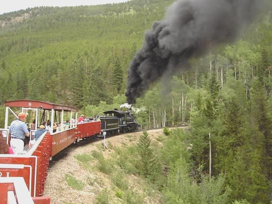
The Georgetown Loop
The trip was great fun, particularly on the return journey, which was all uphill, with the little engine making ‘I think I can’ noises all the way, and puffing out black smoke. Several of the carriages were open, and luckily the weather, which had become quite cool, didn’t deteriorate until we had returned to Silver Plume, when it came on to rain unpleasantly.
Adrian had another busy time videoing, and was glad that the train went on under the high bridge at Georgetown, before the train climbed back up to go over it ourselves. We were saddened to learn that, as we had heard the other day, the line is closing this year. Although our trip, being the last of the day, was fairly quiet, the previous train had been full of happy holidaymakers. Felix would have loved it!
Back in the Bam we returned to the freeway and drove on (still descending fast) past Georgetown and turned off just after Idaho Springs - at a dreadful junction, where the slip road left the freeway on the offside, on a bend! We found a spot just above the pleasant rushing river (Clear Creek). It rained, but later it cleared, so Adrian cooked the excellent tuna steaks outside.
Wednesday 21st July 100 miles
The road was as noisy as we imagined it would be! We left early on a sunny morning, but the sun couldn’t get down into the gorge. It was beautiful as we drove along the gorge, going through several tunnels, rather like Italy or Switzerland. The road was very busy. Soon we came to Black Hawk, and whereas there were remnants of an interesting old mining town, it was now full of huge casinos, looking very incongruous in this lovely setting.
We came out of the gorge, and at 8 o’clock we stopped for breakfast in the sunshine, looking out to a pond. It was 9 o’clock by the time we left and headed for Nederland, a very attractive former mining town.
We got some more fuel, then visited the visitors centre, hoping to find out something about Rocky Mountain National Park, where we are heading. We didn’t really find anything out. We tried once more, unsuccessfully to phone Emma. We found that the computer logged in, but again there were no messages.
We continued through beautiful forested mountains, with lots of wild flowers, stopping for coffee right beside a delightful rushing stream, a fork of the St Vrain River, in the hot sunshine.
At Estres Park we entered the Rocky Mountain National Park, It was beautiful, with wild flowers everywhere, and numerous mountain peaks topped with snow. Also, it was busier than other places we have visited! We made our way to Moraine Park campsite, where, after a lengthy consultation, we were given a site number. We made our way there, only to find that it was already occupied! Back we went, and after much more discussion, they realised that it was their mistake, and gave us another (nicer) pitch. We ate our lunch at the picnic table, surrounded by flowers, birds and chipmunks. The sun had come out, and it was really hot.
As camping here costs $20, we wanted to fit in as much as possible, so set off to explore the roads north of here.
We found our way across what is called Horseshoe Park, where lots of oxbow lakes formed on the Fall River. Bighorn sheep often frequent this area, but we didn’t see any. We stopped at the alluvial fan and walked across rocky ground, where a humming bird was feeding from the fireweed, to an attractive area of waterfalls. Here, in 1982, there was a disaster when a 1902 earth dam burst, and the water poured down, bringing all the rocks and debris with it. Today it was a place where families were happily enjoying the scenery.
We now drove back past the campsite to Sprague Lake, where we enjoyed a half mile amble around the lake, making us think of South Lake, with its ducks and ducklings. It was rather busy with families walking and fishing.
The road beyond here was closed to private vehicles, as they were remaking the road. You could only travel by shuttle bus, and we arrived back at the stop just as the bus was about to leave. As they only left every half hour, we were very pleased! It came on to rain at that moment, but by the time we arrived at Bear Lake, 20 minutes later, the sun was shining.
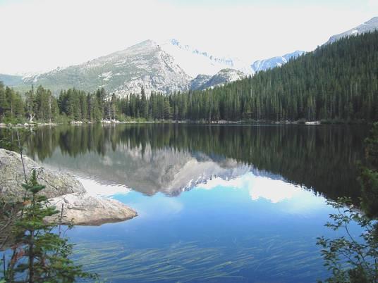
Bear Lake
We now had another walk around a really tranquil lake, particularly after the other ‘tourists’ had done their five minute walk! There were impressive mountain peaks up behind us, and we arrived back just in time to catch the next bus back! The journey was not really enjoyable, as the road works meant that earth was piled up beside the track, and you couldn’t see much, but I did see a deer (earlier we had seen an elk).
We drove back to the campsite, and as it was after 6 o’clock, Adrian lit the campfire – we had stopped to buy some wood. We were all set to sit outside when rain started in earnest! We ended up cooking the pork chops inside, and eating in, but at least we were luckier than all the tent campers!
After supper, as it had now stopped raining, we walked up to the entrance to try to phone Simon. We had to wait quite a while, and then we couldn’t get through, so it was rather frustrating! On our way back, we could see the thin moon, and the stars beginning to appear.
Thursday 22nd July 70 miles
There was more rain in the night, but we woke early to a blue sky. We left before 7 o’clock and set off to follow the road westwards through the park. The mountains looked lovely against the clear sky, but we were in for a day of erratic weather!
We were surprised how many people were about already. We stopped first to walk to Beaver Ponds, but the only wildlife we saw was a mother duck and her 6 large ducklings! The cool start to the day was already warming up, and by the time we had breakfast, sitting on a wall in the sunshine at a viewpoint, it was beautifully warm. This was short lived though, as we climbed higher and got above the tree line.
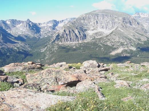
Looking down to Forest canyon
Our next walk, above Forest Canyon, was across alpine tundra, and the air had a definite chill! Apart from enjoying the profusion of flowers here, and the views of the tremendous barren mountains with large patches of snow, we were entertained by a couple of marmots.
We set off on another walk across the tundra, and the flowers here were even more amazing.

On the tundra walk
The fine gravel soil made it look like a wonderful alpine bed! A bit further on we came to a large patch of snow near the road, and couldn’t resist reliving memories of 1965, and walking across the rocks to ‘play’ in it! Luckily, we were the only people around at the time, so we had it to ourselves.
While we were viewing and photographing the lava cliffs, we heard the first clap of thunder of the day. As we came to the highest point on the road (at 12,183ft - 3713m), it began to rain, and as we pulled into the next viewpoint the rain turned to hail! As visibility was pretty poor, we drank our tea and coffee, waiting for the worst of the storm to pass.
We now descended(!) to the Continental Divide, at 10,758ft (or 2 miles above sea level) We were at Milner Pass. Behind us was Poudre Lake (which we braved the rain to look at), with its meandering stream flowing from it, to join other rivers and eventually reach the Atlantic via the Missouri and the Mississippi . In front of us, we pulled into a little trail to Lake Irene, which joined other nearby streams to flow into the Colorado, and eventually into the Pacific. We had a really enjoyable walk around tranquil Lake Irene, with no rain and no other people!
We drove on to Fairview Curve, where we stopped to view the young Colorado River far below us. A lady ranger got chatting to us. She had visited England while her children were working in London and both she and they had loved it. It came on to rain again as we descended by many hairpin bends to the Colorado river. We ate lunch in the Bam by another ‘Beaver Ponds’. Afterwards we walked out to view the ponds, but then drove on to walk a trail across the meadows to former Never Summer Ranch. This was a homestead set up by a German couple in 1917, and run as a dude (guest) ranch for some years in the twenties.
There were several volunteer rangers here, all keen to chat. One lady showed us around the main home cabin, and a gentleman, who we had walked part of the way with, told us about the taxidermy business which the husband had run on the ranch. It was all very interesting stuff, but the rain was returning, so we set off back, diverting to see a large beaver dam on the Colorado river (but no beaver!)
When we had first pulled into the parking area, there was a large male elk, sitting by the roadside as if on duty! We were surprised to see our original lady ranger here, directing cars in to the parking area.
Our last walk in the park was supposedly beside the Colorado in Coyote Valley. However, this had been set up as a wheelchair accessible path, so didn’t actually follow the river. As the rain returned, we didn’t complete the walk.
We now left the park, and came into Arapaho National Recreation Area, after passing the small town of Grand Lake. There were a series of reservoirs here – we pulled into a picnic area on Shadow Mountain Lake – our ‘Golden Eagle’ pass meant that we didn’t have to pay, or we wouldn’t have bothered! At the next reservoir, Lake Granby, we looked into a large camping area, where sites were expensive on top of the entrance fee! We have realised that recreation area generally means boating and fishing, so is of little interest to us!
We drove on past the town of Granby, and found a bit of rough ground across the railway line just after Windy Gap Reservoir. Ground squirrels were running everywhere, but even they ran for cover when hailstones the size of moth balls bombarded us and bounced up off the ground!
Our time here was short lived though. Just after Adrian had poured the drinks ( much needed, as he had been trying in vain to mend our cassette player, as we have no music to listen to), a man walked up and said that we were on private land and couldn’t stay! There was nothing for it but to move on. The man had mentioned a place in nearby Hot Sulphur Springs, where we probably could have stayed, but before that we came to some BLM land, and drove up a rough track until we came to a bit of ground suitable for us. All around were hills covered in low scrub.
Friday 23rd July 126 miles
It was cool when we woke, with blue sky, but clouds were already forming. We had breakfast and left at 8.45. We drove the few miles to Hot Sulphur Springs, but found that it cost $16.50 each to go in (Lonely Planet said $6). Much as I longed for a free day to catch up, and there was a tatty little park next door where we could have stayed, we decided against it. Sometimes we are just a bit too stingy!
We drove down through a lovely gorge, with the railway and the river again, then came out into an area of dry scrub. We followed Muddy Creek to Muddy Creek Pass (8,772 ft), which was once again on the Continental Divide. We followed this to Rabbit Ears Pass (9,426ft), still on the Continental Divide, through forests with ponds and flowers. As there were streams shown on the map on either side of the road, we wondered where each little raindrop would end up – in the Pacific or the Atlantic!
Now it was a very long descent to Steamboat Springs. This town, a ski resort in winter, was much larger than we had imagined. We drove around a bit until the computer logged in, and received a message from Simon saying that they still hadn’t got their stuff from the container. We sent a message back to him, and one to Emma, who we still haven’t contacted, but later we had a voicemail message from her.
We now found our way to the Hot Springs. We were very pleasantly surprised at the pools, and spent the next hour and a half enjoying swimming and soaking! There were several pools, including one where the springs were bubbling up through the bottom. One cooler pool was suitable for swimming. It was lovely to see parents with little children, all enjoying the water – this is the temperature water should be to entice children to like it! There was a really friendly atmosphere, and the showers afterwards were better than at any campsite, and even had shower gel, and a spin drier for wet cozzies!
We now left to drive westwards along the pretty Yampa Valley. After some miles, we tried the ‘freebie’ place we had a note of, but decided that the road was much too busy and noisy, so carried on.
We soon turned off towards a reservoir, which had a State Park. We hoped to find somewhere along the road, but there was nothing. After the reservoir, the road became gravel, but there was still nothing – it was all farming land. After several more miles, we came to a road junction, and realised that we could continue on the unsurfaced road, rather than turn back. Soon the gravel road turned to dirt, and was really rough. We couldn’t have stopped here, even if we found somewhere! After more miles, the road turned to gravel again, and just as we came out to the surfaced road, we found the first pull off in all these miles! It was now 6.30.
The sky was an amazing mixture of unbelievable clouds – it looked like bad photo editing! We had some spots of rain, and much wind, and even more fantastic skies as the sun went down, with a rainbow across a dark grey cloud!
Saturday 24th July 171 miles
We were awake early to see the sun rise, but then cloud came up, although the sky was blue again by the time we left. Amazingly, the computer had logged in (in what seemed the middle of nowhere, but there was an old house nearby), but we had no messages.
As we drove westwards, the landscape became much drier, but we did see white patches from hailstones beside the road. We passed 2 places where we could have stayed last night, if we had kept going!
We were now almost back into Utah, and were hoping today to visit Dinosaur National Monument. There are several roads into this wild area, but the first one we stopped at led only in to the river, so we continued for about 30 miles to the next road in. We had coffee before driving on the ‘Autotrail’.
This led for just over 30 miles to stunning canyon views through dry and beautiful landscape. The best thing was, that although it was Saturday, there were very few other people about.
We had purchased a little booklet for 50 cents, which had points to look at, and was written in a thought provoking way. We walked one little trail on the way, enjoying the warm sunshine, and scenery very different from the Rockies, some of which we could see in the distance.
We had lunch at Canyon Overlook, sitting outside on our seats in the shade, as it was too hot in the sun. There were many 4x4 trails down into the canyon, but we had to suffice with our views from the top. An interesting phenomenon was a large number of huge beetles on the road – they seemed to be devouring each other, and many of course had been run over.
By the time we got to the end of the road, it was 3 o’clock. There was a 2 mile return walk from here, which we perhaps should have gone on, but we made do with the views from the overlook.
We now set off on our return journey, and out of the park. We soon came to the small town called Dinosaur, and then drove into Utah (part of the park road had also been in Utah).
We intended to visit the next park area, some miles on, but before reaching that we came to some BLM land, so turned off and found a place for the night. We enjoyed a cup of tea sitting outside in our own wilderness.
After that it was a wonderful evening – we enjoyed sitting outside, something we haven’t done for a while. It was too hot to sit in the sun even then! It was still warm when we looked at the stars at bedtime. Top Spot!
Sunday 25th July 100 miles
It was a beautiful morning and I cleaned some of the outside of the Bam before breakfast. By then it was already too hot to sit in the sun, so we found some shade to sit in to eat our pancakes, in our peaceful isolation!
Back on the road, we continue west, stopping at a BLM Viewpoint, where we were sorry to learn that there is no BLM (Bureau of Land Management) in the east of USA (as you can free camp on much of it).
We drove on into this part of Dinosaur National Monument, after the little place of Jensen. This part of the park is where the dinosaur bones are. We had to travel a short distance by shuttle bus, and one was just about to leave. It dropped us outside a large ‘shed’, and as we walked inside, my breath was taken away by the sight of a cliff side with dinosaur bones jutting out everywhere! Surely a little boy’s dream! (or maybe they just want to see the ‘real’ thing via models or films!) I was quite gobsmacked.
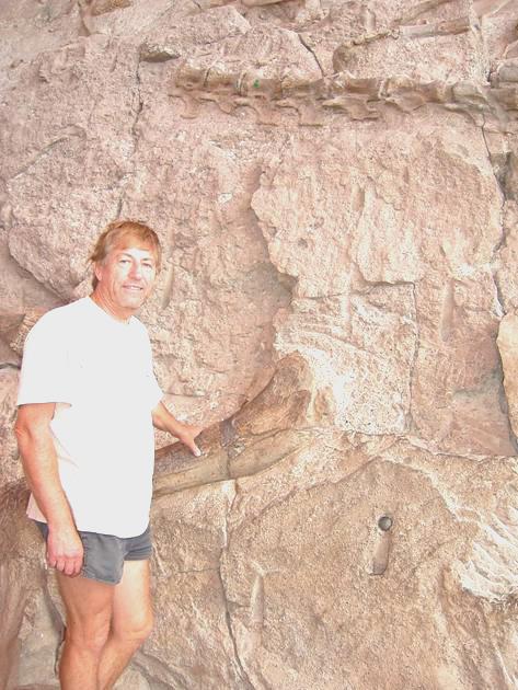
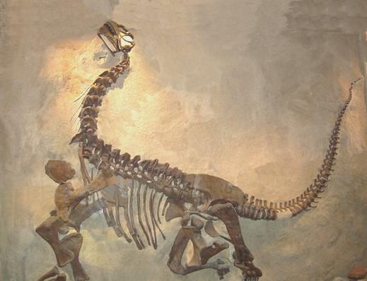
Camarasaurus reassembled
The first discoveries here were made in 1909, and many complete dinosaurs were excavated in the 1920s. We watched a bit of old film of them doing it. When they got down to the ‘odd bits’ they left them, which is what we were seeing now. Apart from the bones, there were lots of relevant exhibits – all good stuff!
By the time we had taken the bus back to the Bam, it was nearly 11.30. It was too hot to sit in the sun, and too hot in the Bam, until we had driven on a bit.
We started off on another ‘Autotrail’, stopping at the first point, some petroglyphs. It was very hot! We drove on to the Green River and I cooled my feet in it! There was a 2 mile walk here, but it was too hot in the midday sun! We had lunch near another part of Green River, finding a partly shady picnic table.
We now drove on to the end of the road, the last 2 miles of which were unsurfaced. Here we stopped at Josie’s cabin – the isolated place where a lady called Josie Bassett had homesteaded for 50 years, until she died, aged 90. She must have been a tough old bird, although from photos she didn’t look it. We walked for a short way into Box canyon, which she had used as a natural corral for her livestock.
Now it was time for our return drive, stopping to view and photograph some of the amazing rock formations on the way. We left the park, and drove back into Colorado at the small town of Dinosaur, then across rather dull, dry, ‘oil’ country, with lots of ‘nodding donkeys’ to Rangely. We amused ourselves by playing I spy!
From here we drove south through more attractive canyon country and came across an unsigned rest area. There was a little trail you could walk here, to view petroglyphs and pictographs and suchlike! It was still hot, but we enjoyed our own discovered walk. Back at the Bam, we settled in and Adrian lit the barbecue.
We sat outside and didn’t come in until after 9 o’clock. Only 2 cars had pulled in during that time.
Monday 26th July 91 miles
A partly cloudy day which started cool, but became very warm and stormy. We walked out briefly before breakfast and left at 9.30. We continued down the canyon, stopping to view more pictographs, then soon began ascending to Douglas Pass (8,268ft), which was very green and forested. As we descended, the land became drier and very flat.
We now came to Fruita, where there was a Colorado Welcome Centre, so we went in to get a leaflet on the Colorado National Monument. We tried once more unsuccessfully to phone Emma.
The rest of the day was spent doing ‘useful’ (or ‘useless’ things). Firstly we got some propane, which we were in great need of. We drove on towards Grand Junction and located Circuit City, in order to look at a new car CD player. For the last few days, we could play music at full volume, and just hear it very quietly! What we found out was that you can’t get car radio cassettes now, only radio/CD players. This was what we had to settle for.
Next thing was to get the tyres balanced, as Adrian was concerned about them. This was achieved very quickly, and went really smoothly, until Adrian went to drive out of the workshop as instructed, and there was a great cry of Whoa, as the workers beckoning him out realised that we were going to hit the roof!
We now drove around for some time trying to get internet connection, but very frustratingly we weren’t able to log in, although things indicated that we should be able to. We drove off down the freeway, when we suddenly got a message from Tom in Slovenia! I had been pressing keys as we drove along, and something had worked!
Next thing was to look for a food shop – in all our driving around we hadn’t seen any. We had past a store called Lowes, and I remembered shopping in a store of that name. This place, however, was a giant sized B&Q! No food here, but Adrian was pleased to find some things he had been trying to buy for ages, so he was happy. After stopping for fuel, we did see a food store – City Market. We had seen this chain before, but not tried it. In fact it was quite a good shop, and as a bonus one of our discount cards worked.
Now all we needed was somewhere to stop for the night. It was too late to go into Colorado Monument tonight, but on the road in to it, we were delighted to find a large parking area at the start of a long trail across BLM land. We pulled in at 5.30, as rain began to fall. Adrian fixed the new CD player.
Tuesday 27th July 112 miles
We had a ‘Curtain springs’ feeling when we woke at 7 o’clock to find the car park buzzing with cars and people! It seems that they all came to walk/cycle/ jog/ dog walk. We left at 7.30 and drove on into the park. We stopped at ‘Cold Shiver’ overlook and had breakfast.
We drove on through the park, stopping at all the viewpoints to the stunning canyons and rock formations. We had coffee at ‘Independence Monument’ overlook and soon afterwards we walked the Otto trail. This was named after John Otto, the eccentric man who was behind the making of this as a National Monument. We had fine views from here, and from the Window Rock trail which we walked soon afterwards. We could see rock climbers high up on the ’Sentinel Rock’ – it wouldn’t do for me!
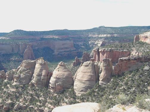
The ‘Coke Ovens’
It was now time for lunch, but there was no shade at the picnic site, so we continued a bit, and had lunch sitting in the shade of the Bam at a ‘historic trails’ viewpoint, where we looked down to the flat valley, and to storms on the distant hills. We left the park at 2.15.
We came out to Fruita, where we had been yesterday. We left on the Freeway westwards.
Soon we were back in Utah. We were amused by a sign saying ‘Eagles on Highway’ (we didn’t see any.)
We turned off across dry desert, but didn’t stop, because of the severe lightning storm. It was very flat, with virtually no vegetation. All of a sudden we found ourselves in a gorge, and stopped by Dewey Bridge, an attractive suspension bridge built in the early 20th century, as the only crossing of the Colorado in this area, and recently restored. We walked over the bridge and around, and we would have stopped here, but on the other side of the road was a ‘proper’ campsite, so we continued down the gorge. It just became more and more remarkable. We were dumbfounded, as we had no idea how fantastic this road was going to be – it matched anything we have seen so far. We just felt annoyed that we couldn’t appreciate it properly, as we were ready to stop, and tired and hungry.
We passed several $10 campsites, and were really giving up hope, when we found an unprepossessing site just above the river for $5 (and no easy way of paying, so it was free!) We pulled in, and Adrian soon got a fire going. We sat out enjoying this idyll until 9 o’clock, when the rain finally reached us, just as we were about to come in.
Wednesday 28th July 67 miles
It was sunny when we got up, so the red rocks looked even more stunning. In fact it was a day of stunning scenery. We left at 8.30 and continued driving down the canyon beside the Colorado River, stopping once or twice to view and photograph. Just north of Moab we turned north for a few miles until we came to Arches National Park.
Here there was more staggering red rock scenery, as well as numerous natural rock arches – apparently over 2,000 of them! We sufficed with seeing just a few. We stopped at all the viewpoints and walked many of the trails. Lots of photos today, especially in the morning, when the sky was clear blue! In the afternoon, the usual clouds formed, but there was no rain today.
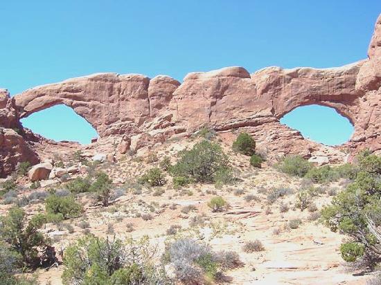
We very much enjoyed the trail to the ‘Windows’ – two arches, which looked very much like two large eyes. We returned via the ‘primitive trail’, which meant that it was a bit rough, and there were far less other people! We had coffee afterwards before walking to ‘Double Arch’, a very aesthetic set up, with two arches set at different angles. This walk was popular with families, so a bit busy!
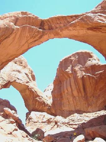
The Windows
We drove on some distance now, stopping to walk to the viewpoint to famed Delicate Arch. We opted not to walk actually to the arch, but there was a trail not on our map to an ‘upper viewpoint’. This just meant that we got puffed by climbing up to a position where we could see the arch, but not the sky behind it. It looked better from the viewpoint 100 yards from the car park!
Now it was time for lunch before walking to see a small homestead of the Wolfe family who had lived here in the early 1900s. The colours changed as we drove through the park, with yellow, pink, green and orange tints. We now drove on to the farthest point of the road to walk to Landscape Arch, diverting to see 2 more arches on the way. Although this walk was in shade for a bit of the time, it was extremely hot. Part of Landscape Arch (the widest in the park) had collapsed in 1991, so now people aren’t allowed to walk under it. We returned to the Bam at 4 o’clock, feeling very overheated, so decided that we had done enough walking for today! We set off driving back out of the park, and then north for a few miles, through a section of roadworks.
We turned off on the road to Dead Horse Point SP and Canyonlands NP, both of which we want to visit. Just along here was a free BLM camping area, so we pulled in, once more surrounded by dramatic red rock scenery.
Soon afterwards, Adrian lit the barbie. We sat outside to eat our steak, enjoying the swallows and bats that were flying around, and our relative isolation.
Thursday 29th July 70 miles
Another day of staggering scenery! The sky was blue when we left at 7.30 and drove on into Dead Horse State Park. This we had to pay for ($7), as it was a state park, not a national one, although it is surrounded by national parks. The views from here were amazing – a bit like Goosenecks, but in red rock, not black.
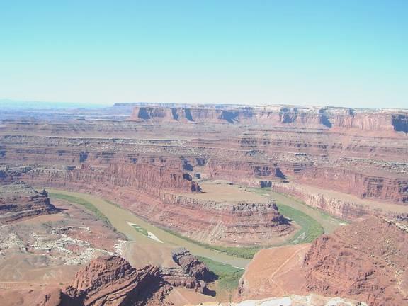
View from Dead Horse Point
We had breakfast at one of the picnic tables. Adrian got chatting to a pleasant couple whose English son in law has parents living in Street.
We now had an hour’s walk around the ‘head’ of this park, which is connected by a narrow neck of land. The name apparently refers to the time when cowboys of old used the point as a natural corral, and one time the horses were left without water, and died. The views all around were out of this world – just barren deep red rock canyons (2,000ft down).
Now it was time to drive on to Canyonlands National Park, which we could see from Dead Horse. We arrived at the Visitors Centre at midday, and tried one more time unsuccessfully to ring Emma. We could look across to Dead Horse Point in the distance. After driving across another narrow neck of land, we came to the area know as Island in the Sky. It certainly felt a bit like that, as we were on high land with the Green River meandering on one side and the Colorado on the other. However, as they are 2,000 ft below, the confluence cannot be seen from the park. Halfway down is the White Rim trail, a track which can be driven along the flat rock surface, where the red rocks are edged with white.
We made our way first to the campsite, and ate lunch at a picnic table in the shade, plagued by midgies and flies in an otherwise idyllic situation. Camping here is only $5, as there are no facilities, not even water.
We drove south to what is called Grand View, and could look out to the overwhelming vista of deep barren canyons, and to another section of Canyonlands N.P. called The Needles, because of its rock formations, across the Colorado River (and many miles by road!)
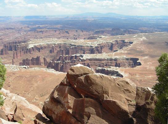
Grand View, Canyonlands
We drove back up, and took the westerly road, past the campsite, to what is called Upheaval Dome. Here we walked a supposed quarter mile trail (upwards) to view a strange rock formation of an eroded dome, looking more like a crater. Scientists disagree about the formation of this – some think that it was caused by a meteor landing here, others think that it was an upheaval of salt, pushing up the rocks above it. If we hadn’t been told, we would have thought neither! By the time we had returned to the Bam, it was after 4.30. We drove back to the campsite, stopping to look at Green River overlook, which again was breathtaking. As we stood there alone, the wind blew really hard, and we could imagine a dust storm. It was 5.30 when we got back to the campsite.
After supper we drove back down to the Green River overlook to watch the sunset, but the sun was partly hidden by cloud. We came back and sat out under the almost full moon.
Alamosa to Canyonlands


A little boy’s dream!
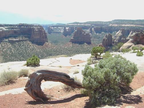
Colorado National Monument
Double Arch