
Wednesday 10th August 2005 10 miles in Bam
This is the start of our travels from North Carolina, north towards New England.
We had returned from Dorset on Monday, where we had celebrated Jon and Lynsey’s lovely wedding with nearly all the family, many of us camping for the weekend at Sixpenny Handley.
We were both up early, and were ready for our 9 o’clock taxi to Gatwick. We have never had a taxi all the way before – this was our way of using up our travel tokens, and we certainly enjoyed it! Our driver was a young chap with plenty of chat and much charm. He had previously worked in security, and liked to tell a story! He was planning to get married in a couple of years to his boss’s daughter!
Our check-ins were easy, and all the people pleasant. One guy was training, and we thought that our 3 month trip was not the usual one he asked questions about!
We had rear window seats on the plane, although we soon went into cloud. It cleared as we flew over Southern Ireland, and we also enjoyed some of the stunning east coast of USA later. We both (separately) saw the watchable film called ‘Heartless’, but otherwise the flight was unremarkable.
As we approached Raleigh/Durham, a storm was brewing, and we landed through heavy rain, although the runway was dry. By the time we were able to get off the plane, the rain was bucketing down. This was the start of the fiasco. Only a few people at a time could get off the plane, as the immigration hall was small, so we, being in rear seats, had to wait a long time! Having then queued to go through immigration, we were told that the baggage couldn’t be unloaded from the plane yet, because of the storm. Was this a similar storm to the one which caused the shuttle to be diverted to land in California instead of Cape Canaveral yesterday, we wondered.
When the baggage finally arrived, it, and the carousel were extremely wet! Then more queueing – first to go through customs, and then to ‘re-check’. We had been separated from ongoing passengers, but then we all seemed to come together to hand in our bags once more and go through security! This got Adrian really bothered, as he thought (understandably) that we were sending our luggage onto another plane. I almost had to hold him down!
Sure enough, our bags went off, and after a very long walk (Adrian with his sprained ankle) we were reunited with them at another carousel! It appears that the airport has been altered to cope with the new security measures, and the ‘customs’ bit is now in the wrong place!
We now headed out to the taxi rank, and had a pleasant driver to our storage place, even if he didn’t know where Route 70 was!.
We arrived there just before 6 o’clock, as the ladies were about to go home, but we were able to fill up with water from an outside tap.
The Bam started up immediately, but now we had to decide where to go. We had enjoyed the State Park which we had stayed in for our last night in April, but knew that we would soon be wanting to sleep, so wouldn’t appreciate it, and it was in the opposite direction to where we wanted to go. We decided therefore to head for (yes) a Walmart carpark on the outskirts of Raleigh, despite the heavy traffic which we had seen on our way from the airport.
It was now extremely hot and humid, so after doing most of our unpacking, and dripping with sweat, we crawled into bed soon after 8 o’clock. The only mishap was the soy sauce which had fallen over and leaked out everywhere!
Thursday 11th August 212 miles
We managed to get some sleep during the night, despite the heat, but were awake very early. Adrian went into Walmart to get milk, bread and cereal while I wrote the diary.
We left at 8.15, and found our way to Jeffrey’s RV Storage, where we hope to leave the Bam next time. Finding the place was no mean feat – we scoured the long road it was in, then went back again, but the place was off a long track, and really ‘out in the sticks’. Eventually a woman, who turned out to be Jeffrey’s mother, came out to help us. Even then we had trouble getting anyone to answer, but eventually his wife came to the door. It is a very low-key place, with just a few RVs stored there, so we hope that they will have room for us in November as it is considerably cheaper than the other place. The reason for us coming today was that they kindly let us have our post sent there, as this wasn’t possible at the other place. Adrian collected the several boxes of things he had ordered (including a new computer, which he later found to have a fault), while I made us some tea/coffee. It was already really hot and humid.
Next we located a shop – called Lowes. This amused us, as on a previous trip we had pulled into a ‘Lowes’ to buy food, and found that it was a large hardware store. We will have to remember – the green ‘Lowes’ sign is food, and the blue one is hardware. We did a big shop, then headed out of the huge Raleigh/Durham/Chapel Hill area, travelling westwards.
We stopped for lunch at a shady rest area near Burlington , sitting at a picnic table under the trees. A young couple came to admire our van. They were on their way to a ‘fiddlers convention’ at Galax.
We continued west to Wilksboro, aiming to camp at one of the sites on W.Kerr Scott Dam. We had a brief and successful diversion when Adrian spotted a ‘Radio Shack’, and was able to buy a new battery for his video camera, as one had given up just before we left home.
Then came the fun of finding the campsite. The directions looked easy enough, but both the road numbers, and the name of the site, didn’t tie up with our information. With road numbers like 1145, 1155 etc this wasn’t easy.
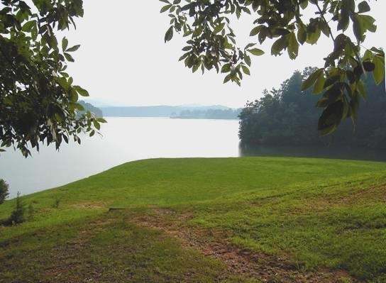
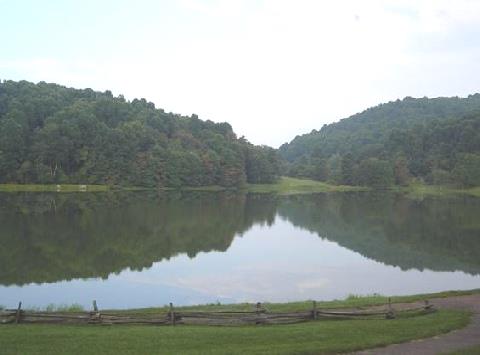
W.Kerr Scott Dam - where we had lovely swims
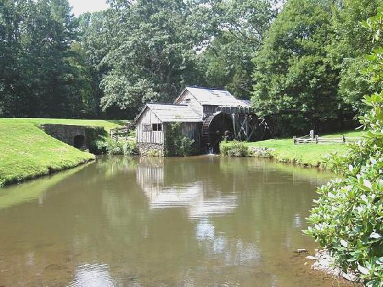
We finally arrived at Fort Hamby Park. Imagine our delight to drive down to a picturesque lake where we could swim in the idyllically warm water, before driving back to the camping area. We saw several deer.
Sitting at our attractive pitch amongst the trees with a beer and crisps (no alcohol allowed!), it all seemed worth it, and it wasn’t long before Adrian lit the barbie, and plugged in the electric for the air conditioning.
We enjoyed our steak, baked potatoes, corn on the cob and squash in our lovely setting, and watched fireflies just before we came in.
Friday 12th August 57 miles
The night was cooler, and we awoke at 7 o’clock to hear the Carolina wren’s distinctive call. It was dark and pleasantly cool under the tall trees. We enjoyed our breakfast sitting outside in this lovely quiet situation, then Adrian successfully fitted our new door lock, which had broken early on the last trip.
We drove back down to the swimming area, where we both had another delightful swim. Swallowtail butterflies were hovering by the ‘beach’.
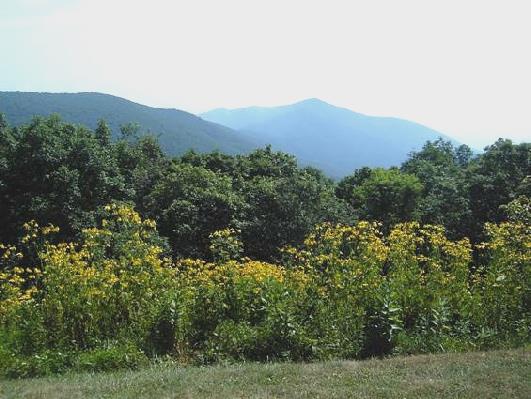
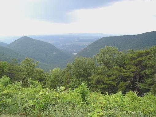
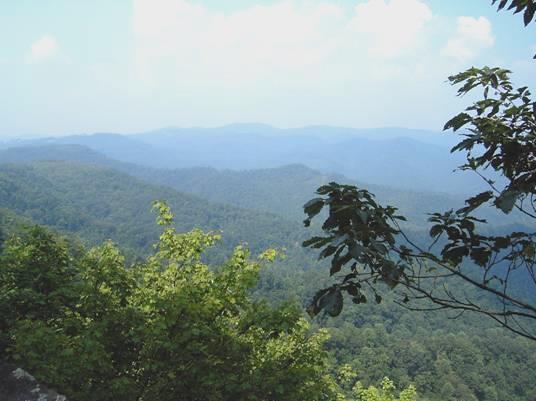
It was gone 11.30 when we left and made our way up route 421 to the Blue Ridge Parkway. This was reminiscent of the Natchez Trace Parkway which we had driven along earlier this year, but the weather was rather different!
We set off northwards, enjoying the wonderful misty views from the many overlooks.
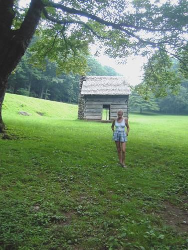
Jesse Brown’s cabin
We walked a short way to Jesse Brown’s Cabin and Cool Springs ‘Baptist church’ – a simple wooden shelter. Apparently people used to come from miles around to the open air service. There should also have been a view here to ‘Tomkin’s knob’, but despite wandering through the woods, we couldn’t see anything.
Just a bit further on we had a lovely walk to ‘The cascades’, through woodland with many butterflies, much fungi, and a little orangey coloured frog. The cascades were delightful, trickling down the steep slopes. It made us think of the ‘Blue Mountains’ in Oz, but no eucalypts here to make the excuse of the blue colour!
We came back to enjoy lunch sitting at a picnic table under the trees, looking through to the misty view.
Our next stop was to walk the half mile trail through the woods to ‘Jumpin off rock’ (we couldn’t find out why it got this name).
View from jumpin’ off rock
On now to Doughton Park, where we pulled into the RV part of the campsite, and found about the last spot to camp. It was now 5 o’clock. It was not as secluded as last night, and we didn’t enjoy the noise of the generators.
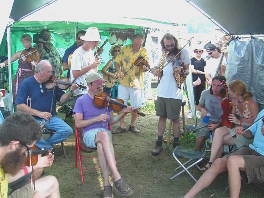
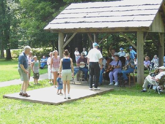
This was short lived however, as a wonderful evening followed. A lady, looking a bit like Olive, had come to welcome us, and tell us that a ‘picking session’ would be happening later. Hence our barbie of pork, squash and baked potatoes was eaten quickly, before we hurried up to join the group of campers playing guitar, fiddle and autoharp and other instruments. It was lovely time, and Adrian went back to get first the camera, and then the video, so we could remember it. It seemed that most of the people were local, and had this jam session at the weekend. Great fun!
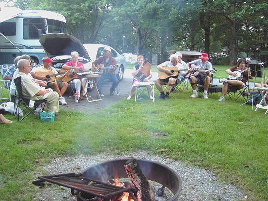
Jam session at Doughton Park
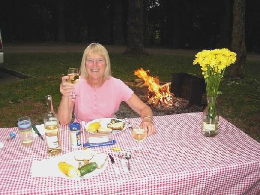
Saturday 13th August Our 39th Wedding Anniversary. 38 miles
The night was cool again, and as our spot was shady, it was pleasantly cool to sit outside for our breakfast of bacon pancakes (more like bacon dumplings, as the batter stuck to the pan).
We exchanged anniversary cards, then had a lovely walk for a mile and a half to Brinegar Cabin.
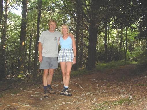
On the way to Brinegar cabin
The walk was through woods and meadows with dozens of wild flowers and butterflies. The last bit of the walk did a long detour, so on the return, we walked along the road for the first bit. We got back in time for elevenses, and left at 11.30 to continue north along the Blue Ridge Parkway.
Again we stopped at the many overlooks – at Stone Mountain, a biking couple from Durham NC told us that all the hotels were full because of the ‘Fiddlers Convention’ at nearby Galax.
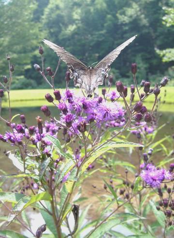
One of the many swallowtails
We walked around Little Glade mill pond, and I photographed one of the huge butterflies. When we pulled into Fox Hunter’s Paradise, we found the layby full not only with dozens of bikers (out in force today) but also with a meeting of sports car owners, stopping for a photo shot. In trying to get through the narrow gap of vehicles parked on both sides, our exhaust pipe scraped one of the sports cars. Our hearts sank, as we pulled in amongst dozens of staring eyes. Fortunately the man involved was very pleasant, and after some discussion, told us to forget about it! It could have been very different!
About a mile further on, we pulled into Cumberland Knob, the last pull-off in N Carolina, and the first area on the parkway to be ‘built’. It was very busy here, but we managed to find a secluded, shady picnic table to cook our cheese/ham tortillas on for lunch. Afterwards we had a really pleasant woodland walk.
We now crossed into Virginia, and soon pulled into the newly built Blue Ridge Music Centre. Normally there would be a concert taking place here on a Saturday, but there was none today because of the Bluegrass festival. There was little to see inside the centre – just information on various local bluegrass musicians. We had become aware of how important music is in this area. It seems that it is a mixture of Irish, English, European and African settlers which forms this Appalachian music. We chatted to a nice couple outside, who were rallying here with their airstream caravan and staying near Galax. They told us how great the festival was. We now knew that we had to drive the few miles to Galax, to see something of this festival ourselves.
We didn’t know what to expect, but were lucky enough to find a place where we could park for $4, and stay overnight! Now we could go outside and explore the small town, set up with many stalls, and wander into the festival itself ($10 each). There was one large stage, and we joined the many onlookers to watch the individual ‘flatfoot dance’ competition – a bit like Irish dancing. It felt a bit like Glastonbury, or Towersey, with hundreds of caravans and tents where the musicians had been staying all week. Impromptu music was being played at all sorts of hidden spots, and we enjoyed wandering around and listening in.
Impromptu music session - Galax
We felt pretty hot, so returned to the Bam to enjoy our anniversary bubbly (absolutely NO alcohol inside the festival), before walking to the nearby Chinese restaurant we had seen earlier.
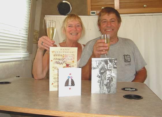
Congratulations to 39 years!
Here we had a wonderful meal of crabs claws and rice before heading back to the festival, where the couple of hundred bluegrass bands were each having their 2½ minute slot on the stage! Again we wandered around the camping area, enjoying the various jam sessions.
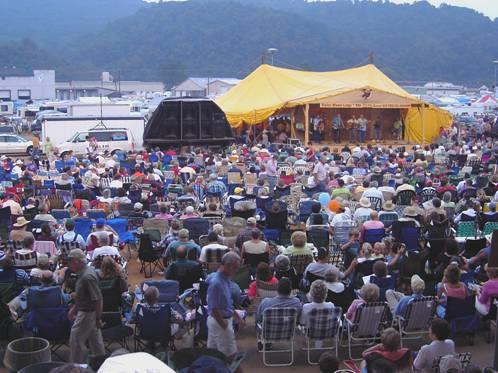
Galax Bluegrass festival
We lasted out until 10.30, when, feeling exhausted, we made our way back to our convenient spot for the night. It had been a different but really memorable anniversary.
Sunday 14th August 59 miles
There was a misty sun lying over the camping area when we awoke at 7 o’clock.
We drove back to the Parkway, having great difficulty with the ‘North/South’ road directions. As we pulled into the first viewpoint to write up yesterday’s diary, and have coffee, a couple pulled in to admire our van.
We stopped by Puckett Cabin, home to a woman of that name, who died aged 102. Apparently she had assisted at 1000 births, after starting midwifery when she was 50. Amazingly, none of her own 24 children survived childhood. She was obviously a character, and a re-enactment of her life was taking place here this afternoon.
We, however, continued now to Groundhog Mountain. The parking area here was very busy, but we found a spot under a tree to have our lunch. A young boy of about 10 got out his fiddle, and played a tune in the shade of his open car boot.
There were samples here of different types of wooden fencing, including the zig zag ‘snake’ fencing which we have often seen.
Mabry Mill was a real little tourist spot, and quite delightful. A man of that name had made his mill here, and it was a really photogenic site. There were all sorts of artefacts associated with the mill, set along a pleasant trail. Under an open shelter, a small band was playing bluegrass music – the young lad from earlier joined them for a while. A few people, young and old, were flatfooting on the adjacent wooden stage. It was a really lovely stop.
Photogenic Mabry Mill
With a bit of Flatfoot dancing
We dove on now to Rocky Knob, stopping by the small visitors centre, and then walking a pleasant but unremarkable trail through the forest for a mile or so. The campsite was a couple of miles further on. We made our way there, found ourselves a spot – it was very uncrowded – and both had a cold shower in the Bam to refresh us.
We had both a barbie and a fire tonight, as I had spotted some unwanted wood by another campsite. We enjoyed catfish, baked potatoes, corn on the cob, mushrooms and courgettes and sat out until 10 o’clock.
Yummy!
Monday 15th August 93 miles
The morning was pleasantly cool as we ate breakfast outside, but soon became really hot. We walked the trail towards Rocky Knob for about a mile. It was an uphill walk, but the walk back gave us lovely views over the forested hills.
Over the gate
We drove the Roanoke Mountain loop – only for vehicles under 20ft! There were disappointingly few lookouts or views. We did walk a short trail to the summit (10 minute loop it said) – but there was nothing to let you know that you had got there. We met a man coming the other way, who said that he had walked for 15 minutes, and not found the summit, so was returning. As it was a loop trail, he must have been almost back at the carpark when he turned round!
Soon after returning to the road, it began to rain violently. Nevertheless, we decided to walk to the Roanoke River overlook, armed with umbrellas! We still got soaked to the skin, as we brushed past the saturated undergrowth in the rain, which had become torrential. We were high above the river, so had to watch our step. It was supposedly 10 minutes to the lookout, but then we followed the sign saying ‘loop trail’, thinking that it would take us back to the parking area by a different and less hazardous route. Not so! It was just a circular walk through the wet forest, and we still had to walk back to the carpark afterwards. We arrived back saturated, but it was still so warm that it didn’t matter.
What do you mean it’s raining!
We continued now to Peaks of Otter campsite, with the storm following us, and arrived just after 5 o’clock. The Appalachian Trail had crossed the road several times.
We saw deer at the campsite, and later a family of wild turkeys.
Tuesday 16th August 83 miles
We left early and saw deer again as we drove out of the campsite. Just along the road, we had a pleasant walk around Abbott Lake, with the forested ‘OtterPeaks’ up above us.
Early morning at Abbott Lake
A few miles further on we stopped at Fallingwater Cascades, and had breakfast before setting out to walk the loop trail around the cascades. The path went down steeply for a very long way, and then of course we had to climb all the way back up again.
High up on the Parkway
We passed the highest point on the parkway in Virginia (3950ft), but now descended to the lowest point at James River (645ft), and walked across the wide river on a pedestrian bridge under the road. On the other side was a small section of a former canal. The canal had been built in the early 1800’s to bypass unnavigable sections of the river. At that time it was the main artery out of the country for Virginian products. It fell into disuse when the railways came. It was very pretty here.
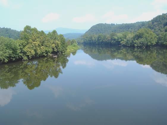
James River
We turned off now to get some (expensive) fuel, before driving on north on the parkway, stopping at lovely Otter Creek, where dozens of swallowtail butterflies we drinking from a damp patch on the ground.
We walked a short way to Indian Rocks, at Indian Gap – it reminded us of many places in Oz, but by now it had now become very stormy.
Indian Rocks
We pulled into Boston Knob overlook, as the rain had become torrential, and driving had become difficult. We enjoyed a cup of tea, waiting for the storm to subside, but as we continued north, we saw that the storm had been even more dramatic, with bits of tree strewn all over the road.
Stormy skies
We stopped at Yankee Horse Ridge, and walked around a bit of old logging rail track – the railway had been 50 miles long in the 1920’s, when the whole of the Blue Ridge had been extensively logged - then continued north, turning off to Sherando Lake campsite, in George Washington National Forest, a few miles from the parkway.
Wednesday 17th August 49 miles
Despite the cloudy morning, we ate breakfast outside. We drove up to the lake – I would have liked a swim, but the cool wind didn’t entice me, although the water felt warm. We headed back to the Blue Ridge Parkway to drive the last few miles of it.
Views were mostly hidden in the clouds this morning, but we did walk the short Greenstone trail, which told some of the geology of the ridge. At least it would have done, if the labels hadn’t been missing or illegible! We did discover that there had been a really big hurricane in August 1969, which had caused much damage and loss of life.
We were now nearing the Humpback Rocks area, but there were so many different parking areas, that it was difficult to sort out where we were. We ended up walking a trail which said ‘.3 mile loop trail’. At first we had read it as 3 miles [the Americans never put the 0 before a decimal point], but thought that we would manage a short walk before coffee. However, after walking steeply uphill for a very long way, we came to the conclusion that the sign meant .3 mile TO the loop trail! It was a long .3 mile too!
At the visitors centre, a bit further on, there was some nice information on the settlers here, and a trail around some genuine old farm buildings which they would have lived in. A local guide gave us a lot of chat about all the artefacts in the house.
We now left the parkway, but the road continued immediately as the Skyline Trail through Shenandoah National Park. There was very little difference, except that the speed limit was now 35 miles per hour instead of 45, and there seemed to be more people about (but still not very many).
The day had now cleared, and again became hot, so we enjoyed the many viewpoints. We stopped for lunch at Sawmill Ridge overlook, sitting under a shady tree, and using a large flat rock as a table, and with a beautiful view.
Further on we walked the Blackrock Summit Trail. We really enjoyed this, especially as it included a tiny bit of the Appalachian Trail,
which follows the course of the road through the park. The summit was composed of bare rocks called talus, which is apparently Hampton quartzite. Some of it was covered in a dark coloured lichen called rock tripe
.
We walk a tiny bit of the 2000 mile Appalachian Trail
We soon came now to Loft Mountain campsite, and drove in and located a spot to stay. We immediately drove back to the campstore to buy firewood and barbecue fuel. There was also a laundry situated here, so we were able to get the washing done before driving back to our site, where a deer was there to greet us.
There were lovely views over the ridges. We enjoyed a barbecue of chicken, then Adrian lit the fire (with difficulty), and we sat out until 10.15.
Thursday 18th August 62 miles
We ate breakfast outside – the sun was trying to shine through the tall trees. Adrian was having fun sorting out his new GPS system. We continued north on the Skyline Drive, stopping again at the many overlooks with their lovely views. We had coffee sitting on the stone wall at Bacon Hollow.
We deliberated whether to walk the 2½ mile trail to South River falls, but thought it would be a nice walk before lunch. When we got to the start of the walk, the distance on the board had increased to 3.3 miles, and the time allowed was 2¾ hours! We still decided to go for it, but hadn’t realised that it was a walk down – often steeply – to the falls viewpoint, and then the long walk back up again, by a different route. We met a couple puffing up the path after about 5 minutes, and they said ‘you’ve got a ways to go’. They were right! However, it was pleasant walking weather, being cooler than previous days, and there were very few people about. The falls weren’t dramatic, but it was a nice walk. The way back up was mostly on a fire track, so fairly easy walking, and then the last bit was on the AT. We passed 3 hikers who were out for a 3 day walk.
It was 1.15 when we arrived back – it had taken us 1¾ hours, not 2¾, but we felt that we had well earned our lunch, which we ate sitting at a picnic table.

Hawksbill Mountain – highest in Shenandoah NP
Carrying on north, we stopped at Crescent Rock overlook, where we walked a short distance to a rocky outcrop to view Hawksbill Mountain (4051 ft) the tallest in the park. We also walked a long ‘600 yd’ trail to ‘Betty’s Rock’, to once again view the mountain.
We did one more walk, called the Limberlost trail. The walk was fairly level, and not very taxing, but disappointingly there were lots of dead hemlocks lying around, killed by a beetle, and dead oaks, killed by the gypsy moth. We saw a young deer and its mother, and have seen many deer today. Apparently they had been hunted to extinction by the 1920s, when the park was being made. 13 animals had been reintroduced, and now there are over 5000. An elderly couple we spoke to on the walk said that they had seen a mother bear with 2 cubs yesterday.
We called in to see Skyland, the resort dating from the 1890s, but by now the weather had become cool with a bit of rain, so it was a short stop.
We stopped to buy some more firewood, then pulled in to Mathews Arm campground at 5.45.
We had got low on stores, and were just cooking excellent prawns (our last fresh food) and rice, when a neighbouring camper came over and asked if we would like some corn on the cob. He gave us 2 beautiful golden cobs, which made a lovely addition to our meal. The evening was damp, and we ate inside, but had decided to light a fire after our meal.
However, we looked out and saw Carlos and his wife playing their guitars by their fire. We walked over to thank them for the corn. By now they had stopped playing music, and their 3 children – Natasha (8), Elizabeth (6), and Josiah (10) – were off to bed. We sat chatting to the parents, adding our wood to their fire, until 11 o’clock.
They were a delightful and unusual family. Carlos was of Italian descent. Both had travelled extensively both before and after their marriage, and had lived abroad – in Japan and Sicily amongst other places, with his job.
Susan, his wife, home tutored her children, and really enjoyed doing it. The children appeared to be really well behaved, and very happy and undemanding. Susan was just pregnant again, and wondered how it would be, having a baby after such a gap. They were very refreshing to meet – very much for organic food, natural remedies, and control over what their children watched on television. We later exchanged addresses.
Friday 19th August 64 miles
There was a lot of rain in the night, but we still sat out in the dampness to eat our bacon and egg breakfast. Susan and Carlos came over to say goodbye, and we chatted some more. Eventually we left too, but by now the clouds had descended, and visibility was very low.
Near the entrance to the campsite there was a telephone, so we attempted to ring Simon and Laure, who had just arrived in England for a short holiday. It was lovely to chat to him – we were just sorry that we weren’t able to see them.
We now drove the last 20 miles out of the park, but sadly no views today because of the cloud, which sometimes made driving difficult. The cloud did lift as we approached the Visitors Centre at Dickey Ridge. We walked a really enjoyable trail through the damp forest, where once there had been a farm and cultivated fields.
We returned to eat our lunch of enchiladas at the picnic area before driving out of the park. We had really enjoyed our week on the Blue Ridge Parkway and Skyline Drive, with little traffic, no commercial vehicles, low speed limit, and with none of the trappings of modern day life.
We hit reality as we drove into the shabby town of Front Royal, which had nothing going for it, except that we did manage to log in and receive one or two email messages. We drove a few miles north, crossing into West Virginia to Charles Town, where we located Walmart.
Saturday 20th August 15 miles
The morning started grey, but became really hot (upper 80’s F) and sunny later.
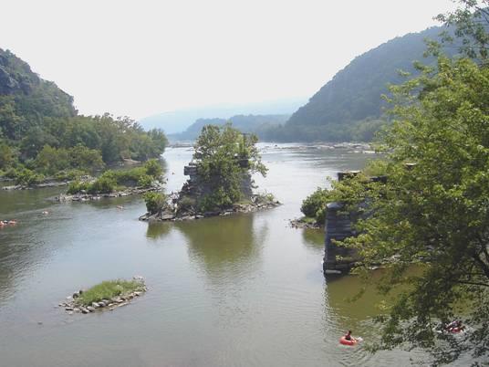
We drove the few miles to Harpers Ferry, and pulled into the National Park car park. A shuttle bus takes you from here down to the town.
A really wonderful visit followed, and we spent the rest of the day there.
Harpers Ferry has so many different aspects of historical and geographical interest. The whole town is a National historical monument, and numerous houses had museums telling of these various aspects.
Geographically, it is at the confluence of the Shenandoah and Potomac Rivers.
Both the railway and the canal built a route through here, and the Appalachian Trail goes right through the town.
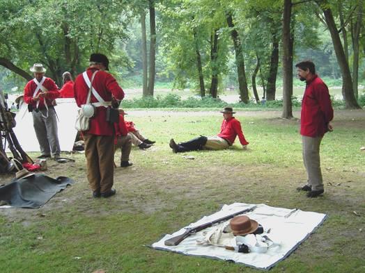
In 1859, John Brown attempted a raid on the arsenal here to capture guns, to use in his fight against slavery, and although he was later tried and hanged, it was one of the things that sparked off the Civil War. The war itself featured largely in the town. Today there were lots of re-enactments of Civil War history, and people in costume were in many of the locations.
In 1803 Meriwether Lewis had bought much of his equipment and had a boat built here for his expedition west with Clark. The town had been very industrial at that time, with 3000 inhabitants, but declined greatly after the Civil War. Serious floods had also occurred frequently, adding another aspect to the town’s history.
The town had also housed a college for black people, and there were many exhibits telling of different aspects of the life and role of black people.
On top of all this, it was a really attractive location, with the rivers cutting into the rocky hills. 3 states meet here – Virginia, West Virginia and Maryland.
We really enjoyed our walk around, crossing right over the Potomac River on the footbridge adjacent to the railway and back, and wandering around the streets of the town, going into each of the ‘museum’ shops to cool down! We even walked up to the Catholic Church, perched attractively above the town. It was very different inside, being neo-gothic, with interesting stained glass, and false roof supports. The church had survived the Civil War, but had been rebuilt in 1896.
Beyond this is ‘Jefferson’s Rock’ – an outcrop which he had visited, and stated that the view was ‘worth crossing the Atlantic for’.
We were pretty hot as we made our way there, and were relieved to find a fountain to replenish our water bottle.
We’d had lunch of pleasant salad in a most unfriendly outdoor cafe, where you had to ring a bell – a woman pulled back a window, took your order with no interest whatsoever, then you had to wait until she opened another window just long enough to shove your food out! Hardly what you’d call service! Nice salad though!
Our whole visit was wonderful, and it was gone 4 o’clock when we caught the shuttle bus back to the carpark.
As we hadn’t expected to stay so long, we now had to find somewhere for tonight. There was a KOA campsite nearby – not our scene – but nothing else that we could find. We did locate another campsite a few miles away at Brunswick. We started making our way there. Brunswick was an attractive town, and on driving through, we found a place where we could pull off. The only problem was that it was incredibly hot still! Therefore we cooked a mushroom omelette for supper, cooking it outside so as not to heat the van anymore. Unfortunately there seemed to be mozzies around, so we ate inside, and later played yahtzee before bed.
As we hadn’t expected to stay so long, we now had to find somewhere for tonight. There was a KOA campsite nearby – not our scene – but nothing else that we could find. We did locate another campsite a few miles away at Brunswick. We started making our way there. Brunswick was an attractive town, and on driving through, we found a place where we could pull off. The only problem was that it was incredibly hot still! Therefore we cooked a mushroom omelette for supper, cooking it outside so as not to heat the van anymore. Unfortunately there seemed to be mozzies around, so we ate inside, and later played yahtzee before bed.
Sunday 21st August 74 miles
The night was very warm, and a hot, sunny day followed. We left at 8.15 and made our way back via a pretty route, past Harpers Ferry (on the Maryland side) to Antietam. This place, has the infamy of having the bloodiest battle of the Civil war. On one day – 17th September 1862, 23,000 soldiers were killed or injured. You can now drive a trail around the area, which we did. It felt like driving around a World War 1 battlefield. There were plaques and markers everywhere. While realising the relevance of this battle to the Civil War, I couldn’t get myself round the battle at all, but could only wonder at the dreadful loss of life.
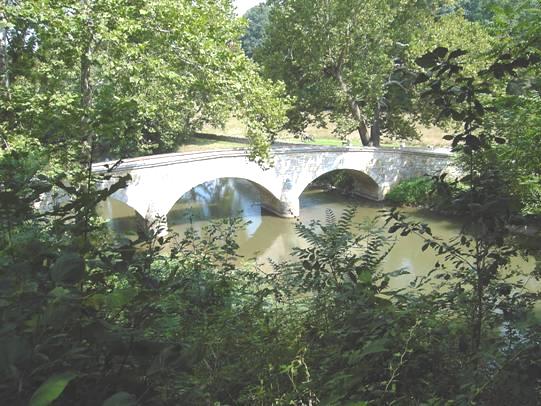
Burnside bridge – one of the Antietam battle sites
After this sobering visit, we drove to nearby Shepherdstown, back across the Potomac River, and into West Virginia. This is an attractive little town, with lots of touristy type shops and pleasant buildings. It was too hot to walk around much, but we did wander through the small ‘farm market’. When we found that a small loaf of bread cost $5, we didn’t buy anything! All we got in the town was a bit more petrol, always hoping that we will find some cheaper!
We now headed north, to Catoctin Mountain Park. This is a beautiful forested area, with a campsite and many trails. Somewhere hidden in it is Camp David, the President’s weekend retreat.
We found ourselves a nice pitch in Owens Creek campsite, and set off to walk the Deerfield nature trail. As in Shenandoah, deer had been hunted to extinction by the 30s, but after being reintroduced, there are now more than enough! We didn’t see any on our walk, but the memorable thing was the sound of a huge tree falling, just as we neared the end of the walk! We didn’t go back to investigate!
Adrian lit a fire, with the plentiful wood, which is free here.
We enjoyed our meal, cooked on the fire, with us sitting in our isolated position. We were amused at a group of people who arrived opposite, and tried to erect a tent. It was obvious that none of them knew how, and the resulting tent showed it! It soon became dark, and they had no torch. We were not so amused, when we heard them still noisily chatting in the middle of the night!
Monday 22nd August 63 miles
The night was really cool, but the day again became hot and sunny.
We made straight for Gettysburg, Pennsylvania, pulling in first at the visitors centre. This also doubled as a museum, and there was a vast amount of information and displays on the three day Civil War battle which took place here on 1st-3rd July 1863. It was the human side of the story that meant most to me – for instance, what the soldiers would have done in their spare time.
We crossed over to the peaceful National Cemetery, and saw the place where Lincoln made his famous Gettysburg address.
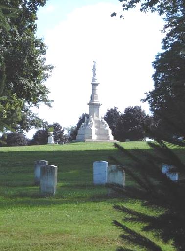
Site where Abraham Lincoln made his famous speech
The thing that was relevant to us, was that Britain might have got involved in the war by giving support to the confederates if the outcome of the battle had been different. As it was, Lincoln, seized on the successes at Gettysburg and Vicksburg (which we visited last time) and in this address made it clear that slavery was the main issue of the civil war now, and that all slaves from the southern states would be freed. Britain did not want to appear to support slavery so did not provide the much needed support to the Confederates.
We set off on an ‘auto tour’ of the battlefield area, which took us the rest of the day. The countryside looks so pleasant now, that it was difficult to imaging the dreadful carnage of that time – over 50,000 dead or injured.
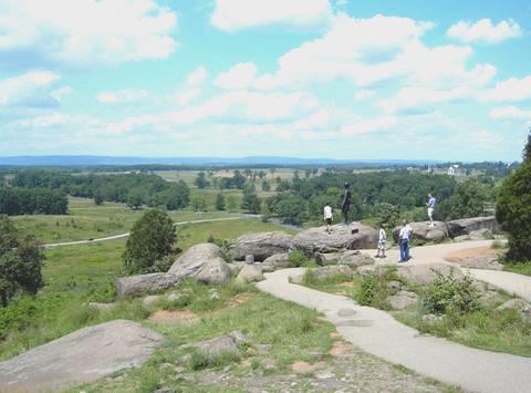
View of the Gettysburg battlefield area
Monuments and plaques abounded – apparently 1400 of them, as well as the information boards telling of various stages of the battle.
Having left the park, we now had to decide where we were going from here, and pulled in to discuss our possible route. We headed for Hanover to yet another Walmart, arriving at 5.30
Raleigh North Carolina to Hanover, Pennsylvania


The Shenandoah meets the Potomac River
Harpers Ferry re-enactment