
Monday 5th July 116 miles
We were pleased that the storm didn’t come to anything. The night had been warm. We breakfasted outside in our desert isolation and left at 8.30.
We drove through stunning desert scenery to Bullfrog, where a ferry crosses Lake Powell to Hall’s Crossing. We arrived at 9.45, and the next ferry was at 11 o’clock. We were amazed at 2 things – firstly the barren red rock scenery, reminding us of Lake Argyll in Australia. Secondly the huge numbers of people coming to boat here. It wasn’t our scene at all, but we filled in the time excellently by having a refreshing swim in the lovely water.
The 25 minute ($18) crossing was very enjoyable, and the scenery looked much more impressive from Hall’s Crossing. We stopped at the little camp store, but only bought bread and a pizza (it is ages since we did a proper shop, and horror of horrors, we are completely out of wine!)
We now continued through the desert, with not enough shade for an ant even! We could see Monument Valley in the distance. We finally found a rough parking area to turn into for lunch. We pulled out the sunshade, but the strong, gusty wind made life difficult!
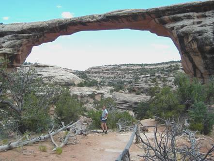
Owachomo bridge
We drove on to Natural Bridges National Monument. There was a nine mile loop trail to drive here, with viewpoints to 3 separate large rock bridges. We walked down to the last bridge, Owachomo, but just walked to the viewpoints to the other two. Adrian was impressed by both the bridges and the trails.
We also walked a trail to view Horse Collar ruins – cliff dwellings of Anasazi Indians set high in White Canyon. It was while we were here that we met Kelly and Marie. Unlike Steve and Ruth, this was a couple we had little in common with! It started when Kelly, a large, dark haired man reminding us of Dr Corden, came up and started talking loudly to us as Adrian was videoing. They lived in Salt Lake City, and were presumably Mormons, as Marie said that her nephew had recently been visiting England on a Mormon project. Marie was quiet and pale, with short fair hair. She had a Julie Andrews look, with a bit of Linda. She had an unnatural childlike sweetness and simplicity, and hung on Kelly’s every word. She said proudly that he was writing a book about American Indians. We wondered what it was like, as he was a ‘Johnny Knowall’ who knew nothing! He said how good it was to get out and walk, and that he walked all over, but they were both so puffed after our short trail that they couldn’t walk any more!
We were glad to leave them, and pleased that we later passed a normal, happy family, where the 8 year old girl was singing ‘Old MacDonald’, so that her little 16 month old brother (in Dad’s back pack) could do e-i-e-i-o.
We drove on to the campsite – practically empty, and Adrian lit the fire.
It had become very windy, but we were rewarded with a wonderful sky, which was followed by a storm brewing, and rain at bedtime.
Tuesday 6th July 88 miles
The storm soon died out, and we awoke to blue sky. We breakfasted outside and left at 8.15.
We drove through more wonderful desert scenery to Blanding, including crossing Comb Ridge, a monocline making a wavy ridge for 80 miles. At Blanding, the first town we had come across in days, we first phoned Em, who was at Elm Gable before leaving for France tomorrow, before making our way to Edge of Cedars State Park. This was a museum of Puebloan pottery, baskets and petroglyphs, and was extremely intensive, with far more than we could take in, but was good to see.
Outside there were some Puebloan buildings, and we could climb down into a kiva (men’s meeting house).
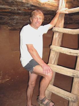
Adrian in the kiva
We drove via the Post office and posted a card to Tom. The shop provided most of our needs, except the much needed wine. We realise that alcohol is not easily available in Utah, being principally a Mormon state. We were able to buy tea though, which they also don’t drink. Down the road we were able to buy some beer, so beer it is!
We left at 3.30 and headed for another Indian site – Hovenweep. This is a National Park, so good news for us. Also there is a campsite here, so we made our way there. We thought that we would have a cup of tea before setting off to walk the trail around the canyon to view the ruins of the Indian homes. We started off sitting out under our strange sun/wind shelter, but at this point it decided to rain briefly! That over, we left at 5.20 to walk the 2 plus miles, in our splendid isolation. We viewed, photographed and videoed, and got back at 6.45 to light the barbie/fire.
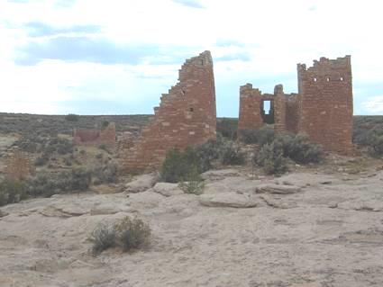
Hovenweep castle
We sat out at our strange picnic table and watched as the sun sank, giving a wonderful sky. Later the stars were fantastic too.
Monday 7th July 135 miles
Another clear blue sky, and it was already hot when we sat out for breakfast at our shaded picnic table, which didn’t actually shade us from the sun! Just after we left the park at 8.30, we saw a coyote running along close by. We watched him for a while, and he kept his eye on us! We drove on through the dry desert, enjoying seeing the large datura flowers beside the road. We now followed the San Juan River to Bluff, noticing the huge difference that water makes to a landscape.
We saw the twin rocks – 2 upright pillars of stone – as we came to Bluff. We stopped by Bluff Fort, where there was one surviving hut remaining from the Mormon village that was once here.
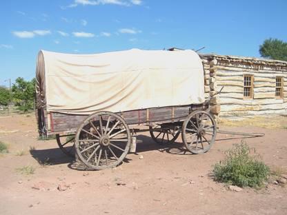
A covered wagon at Bluff Fort
This was where the group of Mormons settled after their momentous trek from Salt Lake City via the Hole in the Rock road. I found the former family home, and covered wagon nearby, very moving, and could picture the hard life the people endured, especially as the wife had died aged 40, after the birth of her 9th child.
Bluff now only consists of a few scattered houses, although it had been important in opening up this area in the late 1800s. We visited the Twin Rocks ‘Trading post’ – there is no shortage of Indian goods to buy in this area.
We stopped just after Bluff at Sand Island, which didn’t seem to be an island, but we were right beside the fast flowing San Juan River. Nearby there were some petroglyphs on a high cliff wall. They were supposedly important, but hadn’t been looked after, and were difficult to see. The access was through prickly bushes, and the protective fence has bushes growing in it, so with the heat as well, viewing things wasn’t easy!
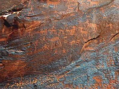
Sand Island Petroglyphs
We continued on our way, crossing Comb Ridge again, at a more southerly spot, but once more there was nowhere to stop. We were heading for Monument Valley, but a few miles before there was a 17 mile dirt road through what is called the ‘Valley of the Gods’. This sounded like fun, but became quite nailbiting as we wondered if we could get through! The road started off better than we had imagined, and we should have realised that they were working on it by the number of large work trucks passing! The surface was ‘variable’ later on, and the van ended up caked in red mud! The scenery was certainly dramatic, with several large ‘lumps’ of red rock in strange shapes. We had set off at midday, and bumped up and down like being on a roller coaster for over an hour. When we finally reached the surfaced road, we relaxed and had our lunch!
A few miles on from here was a turnoff to ‘Goosenecks’. This we had wanted to see, as it was supposed to be an entrenched (incised?) meander. Thankfully the 4 mile road was nicely tarmacked! The site itself was stunning! The San Juan River had cut numerous meanders into the totally barren rock 1,000 below. The Americans would call it awesome! It was also extremely hot and windy, with no barrier to protect you! It was said that you could free camp there, but I wonder if anyone ever did!
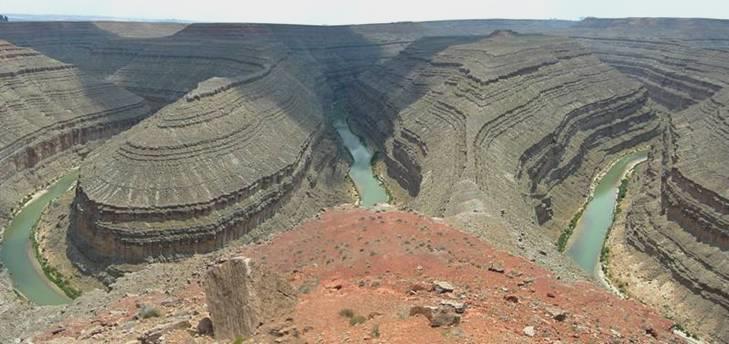
Amazing Goosenecks
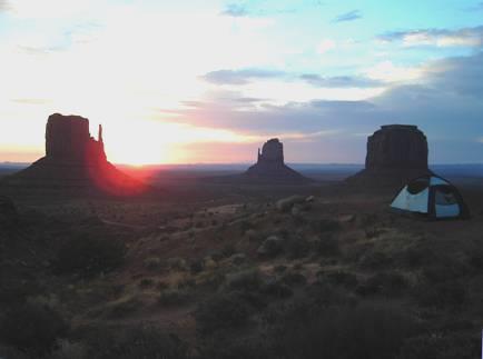
Now it was on to Monument Valley, passing Mexican Hat, a rock shaped like its name, with a ‘town’ named after it. All the time, in the distance, we could see the well known rock shapes of Monument Valley. We were disappointed that, despite being sunny, it was rather misty, so not good for photos. We paid our entrance fee, and set off to drive the 17 miles (again) of unsurfaced track, viewing the rock formations as we went.
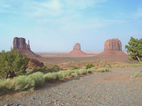
‘The Mittens’ and Merrick Bluff, Monument Valley
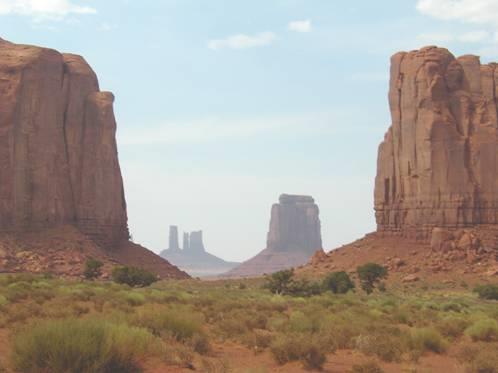
Monument Valley scene
The road surface was in worse condition than the last one, and as it was very windy, we felt full of dust and sand when we returned. We decided after some discussion to camp here – this is Navajo land, and therefore no alcohol allowed. The first thing we did was to have showers in the van (showers cost extra here), then we felt a bit more human. However, the strong wind got the better of me, despite the lovely situation we are in.
We walked around just before sunset, admiring this wonderful setting and stepped out again at bedtime, when once more the stars were fantastic.
Thursday 8th July 138 miles
I had set my alarm for 6 o’clock so that I could see sunrise over Monument Valley, and this I did!
Sunrise from our campsite
After it had risen, the sun went into thin cloud for a while, so stayed with its red glow. It was still partly cloudy as we sat outside for breakfast, so was pleasantly cool.
We drove on empty roads, through sparsely populated desert country of the Navajo reservation and the spread-out nothing town of Kayenta. We came to Chinle, the town near Canyon de Chelly, and saw a ‘Bashas’ store. We couldn’t resist going in there, even if everyone else around was Indian, and we had to hunt a bit for things we wanted. There was no alcohol, of course, being Indian country! (first the Mormons, now the Indians!).
At midday we drove into the Canyon de Chelly, visiting the visitors centre briefly before heading for the campsite. This is a National Park, but both entry and camping are free. We found a shady spot to have lunch, as it was now 12.30. We left at 2 o’clock, to drive the 37 mile round trip of the South rim. We stopped at all the viewpoints to the canyon, which has been home to Indian people for hundreds of years. We marvelled at the remains of some of the cliff dwellings set into the vertical cliff sides. Indians were selling their attractive wares at some of the viewpoints – I bought a bracelet made from dried juniper berries.
By the time we had viewed Spider rock, the last viewpoint, it was 4.40.
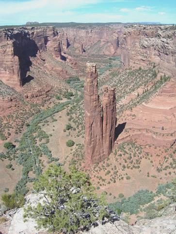
Spider Rock, Canyon de Chelly
We were surprised that we had to walk a short distance at each stop off, but we opted not to walk down into the canyon on the only path allowed without a guide, as we felt that 2 hours or so in the hot sun was too much (to say nothing of the 500ft back up!) .
We arrived back at the campsite just after 5.00. Adrian lit the barbie. The sky was cloudy, so not many stars tonight!
Friday 9th July 225 miles
We were up early and ate breakfast outside, including the last of the apricots, which had been great. We enjoyed the early morning cool, and were watched by yet another longing dog.
We set off to view the North Rim of Canyon de Chelly. Again we were surprised by the long trek to view each site. The first was Ledge Ruin, and we were able to see what looked like tiny buildings tucked into the ledge of the cliff. The temperature was still pleasant.
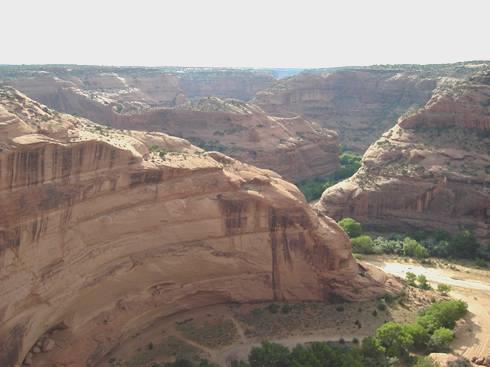
Canyon de Chelly from the North Rim
The second stop was called antelope house. This was an even longer walk. We first saw the Navajo fortress, a huge rock in the canyon, which the Indians apparently used for defence. From another viewpoint, we finally saw wonderful pictographs, one of an antelope, on the sheer cliffs near the ruins.
We saw more dwellings from the last viewpoint before leaving the canyon.
We very soon came into tall forest, unlike the stunted trees at Chelly. We ascended to Washington Pass, then looked right down to the barren desert plains of New Mexico. We now descended for a very long way, and said goodbye to the trees again. We stopped beside Ford Butte.
Continuing north, we turned west at the town of Shiprock, near the rock of the same name. We stopped for fuel at Beclabito, before continuing to 4 Corners monument. This is the point where 4 states – Arizona, Utah, New Mexico and Colorado all meet. It is on Indian land, and is the most God-forsaken bit of desert imaginable!
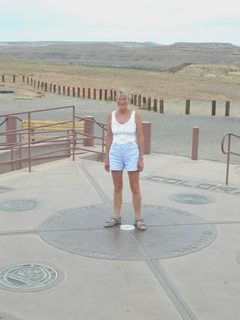
Rosie at 4 Corners
We had to pay $3 each to enter an area of numerous stalls selling Indian jewellery and 4 corners T-shirts. In the centre was a circle with the 4 states marked out. People took it in turns to be photographed here. One could only call it a gimmick. The sad thing is, the government is going to spend $4 million to erect a huge complex here in the middle of nowhere, to replace the simple stalls. We bought a little bracelet for Ruby, then hurriedly left and headed for Cortez.
This was the first town of any size we had visited since Phoenix. We first visited the Colorado Welcome Centre, where we picked up many leaflets, and had trouble in getting away from the chatty ladies.
We visited Walmart and found that we couldn’t stay there overnight as we had hoped. Next we headed for Safeway, as we at last thought that we could buy some wine. Not so lucky! In Colorado, wine cannot be bought at grocery stores! We bought a few other things then made for the nearby tiny liquor store.
We headed out to Mesa Verde, the National Park which we hope to visit tomorrow. We hoped to find somewhere to stop for the night on the way. This wasn’t to be, and we soon found ourselves entering the park. We hadn’t expected to drive 4 miles through mountainside before coming to the campsite! What’s more, it started to rain! Even worse, the campsite here cost $20! and more annoyingly still, we had to drive right down to the campsite from the registration (a long way), select a place, then come all the way back and tell them! Being nearly 8.00, hungry and still raining, it didn’t matter where we went!
Saturday 10th July 66 miles
There was some rain in the night, but we were awake early to a fine morning and had breakfast outside just before the sun came up over the mountain.
We left at 8 o’clock, and drove the 5 miles to the Visitors Centre. Here we were lucky enough to get on to the 10 o’clock tour to visit Cliff Palace. There are 3 separate tours of ancient dwellings in the Park, and all have to be paid for and booked in advance. We had just time to drive on a few more miles to the start of the tour, and get ourselves organised. It turned out to be an excellent tour. Our guide, an American of German descent, had recently completed his doctorate on Puebloan history, so was very informative. He continually compared life in a 13th century Puebloan village with life in Europe at the same time. We had had to climb down steeply to start the tour and then climb up afterwards, some of it on 10 ft long rung ladders. I was surprised at the number of people, many with children, who were prepared to scramble down and back up in order to see the buildings. The nice thing was, we were in the shade of the rock overhang, so it was pleasantly cool.
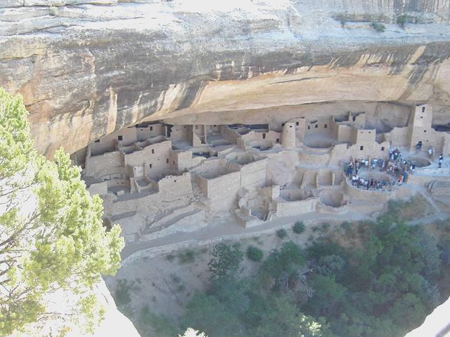
Cliff Palace, Mesa Verde
Now 11.40, we drove on round this loop, stopping at several viewpoints before walking the Soda Canyon Trail. This was an easy walk through forest (mostly dead), to view Balcony House, another of the dwellings that could be visited with a guide. The walk took us 45 minutes, so by now it was now 12.45. We felt ready for lunch, but had to drive on to the Mesa Top loop, stopping at several more viewpoints to see Puebloan dwellings of various antiquity, before we came to the small picnic site. Here we had our lunch at a shady picnic table before driving on round, stopping at more viewpoints on the way.
We drove on now to the museum area, and walked to Spruce Tree House, the one house you don’t need a guide for. Because of this, there were a lot of people around, but it was quite a pleasant visit. Afterwards we looked into the museum, which had a great many artefacts of Puebloan life over the years.
The villages we had mostly been seeing were built of masonry and were the last ones to be inhabited by the Puebloans before they left the area in the late 1200’s. Their departure, most archaeologists now believe, was probably due to a combination of feuding, over-use of the farmland and a 25 year drought, and that they moved south to the Rio Grande valley. However they had farmed this area since about 500 A.D., and we saw various other excavations of earlier houses, mostly ‘mud and wood’ houses and it was interesting to see how the dwellings had changed over the years.
Now it was time to begin our return drive, stopping at one more lot of ruins on the way. We had wanted to drive to the further mesa, Wetherill, but this was a 45 minute drive, and by the time we got there, the road was closed anyway.
We headed towards the park exit, stopping at more viewpoints. At Park Point, we walked up to the fire tower, the highest point, at 8,570 ft. There have been several serious fires in recent years, mostly caused by lightning.
We left the park, and drove the few miles to Mancos. This was a pleasant little town, and our list said that you could park for free in the ‘City Park’. Unfortunately, this is not now so, and so once again we had to find an alternative. A bit further on, we came to San Juan National Forest, and wasted no time in finding ourselves a spot there. It was now 5.50, so nearly time for a beer!
At bedtime the stars were amazing.
Sunday 11th July 161 miles
We were woken soon after 6.00 by a whole lot of cars driving on into the forest! Something must have been going on. We had breakfast and left at 8.15. We drove through pretty alpine country to Durango. We had intended taking a steam train trip from here, but when we arrived at the station and saw how busy it was, we had second thoughts! The packed nine o’clock train was about to leave. We had planned to go on the 9.45 train to Silverton and back, but with our new revised plan, we decided to drive there instead. We hope to take a different train trip in a couple of days from another town.
We walked around the town of Durango, which initially looked really pleasant, but we realised that it was full of smart, posey shops, selling ‘nice’ things for well off westerners! Perhaps it was just too much of a contrast after 2 weeks in the remote desert!
We now left Durango which we had found so ‘neat’, and started on the 50 mile drive to Silverton. The country was pretty and green, with wild flowers beside the road. We had to go over 2 passes – Coal Bank Pass – 10,640ft, and Molas Pass – 10,910ft. There was quite a lot of snow in the crevasses of the mountain peaks.
We had noticed another vehicle like ours as we were driving up, and at Silverton we pulled in behind them. We chatted to the couple, who had been full timing for 13½ years, but had a ‘pad’ at an Escapees park near Tucson. They had lived in Algeria in the past, and their children had gone to an American School in Switzerland. Before that, he had been in the Navy, and had been in Korea at the time of the war. In September he was meeting for a reunion of people from his ship. We looked inside their rig, which was newer than ours, and had a different layout.
We left them, and went to look at the steam train which had arrived, then walked around the town. It seemed very like a northern Canadian or Alaskan town, and made us think of Skagway. It was very touristy and busy, with both train passengers and motorists, but the houses were in keeping with the old mining town, and the shops had more character than Durango.
At 3 o’clock we began our return journey to Durango. We didn’t stop on the way back, so by 4 o’clock we were driving through Durango, and then south towards Aztec. We had crossed and seen the Animas River, looking very attractive and refreshing, many times today, and we had enjoyed the mountain streams higher up.
Just after Aztec, we found a spare bit of ground to pull on to. We could see that the area behind us was used by off-roading vehicles, but were a bit disconcerted when a group of young lads came to race around on their vehicles! Luckily they didn’t stay long!
We ate outside – it was still very warm (nearly 90ºF). We enjoyed our quiet spot until we were disturbed by the sirens of 8 emergency vehicles as we came in at 9.30, but we never found out what it was about. The first stars were just shining, and at bedtime there were many more.
Monday 12th July 141 miles
We were woken early by a surprising amount of traffic. It was a sunny morning. We left before 8.30.
We drove on to the small ‘town’ of Navajo Dam. Adrian telephoned about tickets for the Cumbres and Toltec railway, and found that they were booked up until Thursday! Also, the tickets cost more than we had thought. Having now booked them, we found that we had 3 ‘spare’ days – we had hoped to go on the train tomorrow. We thought that maybe we should have gone on the Durango train yesterday after all!
We now spent a relaxed and ‘lazy’ day, driving first to the Navajo Dam, but as this was a State Park, and therefore required a fee, we didn’t stop, as it only seemed to be of interest if you were into fishing or boating! The cool stream coming from it was well known for trout fishing.
We had to drive right along the high earth dam – there was no barrier of any kind, and the road was quite narrow. It was like being between the devil and the deep blue sea, with water one side, and a great drop the other!
We continued west, stopping in a small section of the Carson National Forest. Soon after this, we crossed a most unprepossessing Continental Divide – 7275ft. We had nearly reached Chama, where the train goes from. This area of the town was not very inspiring, but as we drove along to the old part, the buildings had real character. We pulled in by the station. Adrian was able to wander out a bit and enjoy himself – he liked the feel of this railway much more than the Durango one.
We drove around the town afterwards, and had some rain as we continued south a bit before heading east into the Tusas mountains. We wound up through the forest, and at 4.15 pulled into a so-called picnic area (one shelter minus a picnic table). We looked down to the forest below, with the sky grey and heavy with more showers in the distance.
Later the sky cleared, and we enjoyed our beautiful view.
Tuesday 13th July 130 miles
The night was milder than we had expected, and we awoke to a beautiful morning. A car had pulled in beside us at bedtime and was still there. We enjoyed breakfast with our lovely view, and left at 8.20, stopping soon afterwards to look at the high Brazos Cliffs. We were soon back into Carson National Forest, which at this point was very green and pretty. We came out of the forest at Tres Piedras, and the road from here went across flat, scrub covered land with a few isolated strange underground homes. We could see the mountains in the distance. We knew that we crossed the Rio Grande gorge before Taos, but were absolutely amazed to see the deep gorge beneath us after all this flatness. We walked onto the bridge (bravely, as the river was 650ft below), then viewed again from the picnic site. It was quite something!
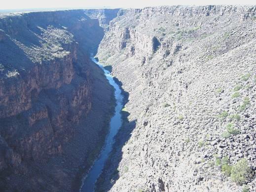
Rio Grande Gorge near Taos
We drove on into Taos, which like Santa Fe, which we had visited 2 years ago, was mostly made up of adobe looking buildings. Taos hasn’t the antiquity of Santa Fe, and lacks the presence of locals selling their wares on the pavement. It was still attractive, but the shops were more ‘posey’, and the tourists very ‘nice’. Also like Santa Fe, it had become an art centre – DH Lawrence was part of the early scene.
We had made our way first to Rachos de Taos, just south of the town, to view the old adobe mission church of St Francis de Asis. The local people had recently redone the adobe, but heavy rains afterwards had spoiled the surface. We peeped inside the simple chapel, before enjoying our coffee sitting on a shady seat in the churchyard. There were flowers, particularly hollyhocks, here and in Taos itself. They looked just right against the adobe buildings.
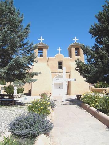
St Francis de Asis, Ranchos de Taos
Now it was time to shop. We found a ‘Raleys’, and as we are in New Mexico, and you can buy booze in the supermarkets, we stocked up on a trolley full of wine! The fruit and veg were better than any we had seen, so we had a pretty good shop! Afterwards we had a tour of the old centre. We had to pay for parking here, but 25 cents for half an hour didn’t upset us too much!
We now left Taos, and drove off on the route called the ‘Enchanted circle’, which circumnavigates it for about 80 miles. We very soon came into another part of Carson National Forest, with several small campsites beside the road. We pulled into one at 3 o’clock, but felt it rather limiting, so continued on our way. We had been following a line of traffic which had formed behind a house being transported, so now at least we had lost that!
We came out of the forest near the town called Angel Fire, which is a ski resort in winter. We soon came to the Vietnam Veterans War Memorial and Chapel. This had been built by Dr Victor Westphall following the death of his son David in Vietnam in 1968. The strangely shaped chapel is always open. The visitors centre contained a great many exhibits and was naturally very moving. A video was showing, but the room appeared to be full, a young white woman was cradling a young black boy near the entrance. We couldn’t see the video, but we could hear it, and like the rest of the memorial it seemed excellent.
Rather sobered, we continued on our way, passing through very busy Eagles Nest, beside a small lake, and ascending to Bob Cat Pass 9820ft, before a very long descent to attractive Red River, another winter ski resort. We were now back into Carson National Forest, with more small campsites. These were mostly beside a little stream, but were quite busy. We pulled into one, but it was $10, the first one had been $5. Luckily for us though, we did come to one more, Goat Hill, and positioned ourselves right by the babbling stream, under the high mountain. Adrian lit the barbecue.
We had a wonderful meal and sat on rocks by the stream to finish our wine, and Adrian even waded in the water, which was very cool!

Adrian having an evening paddle!
The clouds cleared, and we could see the stars at bedtime.
Wednesday 14th July 167 miles
We were awake early and left at 7 o’clock – the sun hadn’t yet reached us. We drove into nearby Questa and got some fuel from a very genial chap, then set off north, stopping for breakfast at the New Mexico/Colorado border.
We soon came into San Luis, the oldest town in Colorado. It was being ‘spruced up’, but we could see that it was an attractive little town. We had seen that there was a ‘point of interest’ here – the Stations of the Cross, leading to a shrine on the hillside. We located the trail, and walked a short way, but even at 9 o’clock, it was too hot for us! Also in this town, a ‘town ditch’ had been built by the villagers in the mid 1800s to irrigate their land. We stopped by it before driving north to Fort Garland.
There was a museum here, in the fort, which was once under the control of Kit Carson. We looked in but didn’t stop.
We now drove west for a few miles before taking the road north to the Great Sand Dunes National Monument. This is an area of high dunes, set between the San Juan mountains in the west, and the Sangre de Cristo range on the east. The sand originally formed from the nearby Rio Grande river.
We joined the many other visitors, and walked for some way across the sand towards the dunes.
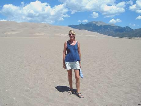
Great Sand Dunes National Monument
A lot of people were actually climbing high up on the dunes (800ft), but the heat of the midday sun didn’t entice us, and we returned to find some shade. For much of the year, a stream flows near the foot of the dunes, but today people were having to dig to find any water. The huge sandy area resembled a beach scene, with kiddies with their buckets and spades, but without the sea breezes and the water.
We ate our lunch in the picnic area, before walking the Montville trail, beside Mosca Creek. Part of this area had suffered from a fire 4 years ago, but there were quite a few flowers, and it was pleasant walking by the little stream. There had once been a small town here of 20 houses, including a shop and a post office. The owner of the shop had constructed a trail over the pass, which at the time was the only way into the valley, and he had charged $2 for a horse and cart to use the trail– a massive sum in those days. Now there was no trace of anything.
We left the park at about 3 o’clock and drove over flat land to Alamosa. This pleasant town had a park where we hoped to stay tomorrow night, after our trip on the railway. We enquired at the tourist office, where a young blonde lady, looking and acting like Liz Fraser, told us that you could stay in the town park free for one night.
We now drove the 30 miles south to Antonito, where our train leaves from tomorrow. We collected the tickets from the station, but weren’t able to stay there for the night. The weather had done its afternoon thunderstorm act, with lightning and weird clouds and just a bit of rain.
We drove back a couple of miles to view what is apparently the oldest church in Colorado, in a shabby little place called Conejos. The church, however, had been burned down and rebuilt in the 1920s! Its smart appearance looked rather out of place amongst the mostly derelict buildings.
Back in Antonito, we pulled into a rough bit of ground near the railway, as the storm returned. It continued for most of the evening, but we enjoyed a meal of tilapia fish tortillas, watching the storm through the window.
Thursday 15th July 31 miles
A wonderful day on the Cumbres and Toltec railway!
We woke at 6.00 am to see the sun just rising into a clear blue sky. We left at 7 o’clock to drive the short way to the station and ate breakfast here before boarding the coach at 8 o’clock, joining the many others who had already got on for the hour’s journey to Chama.
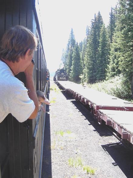
We left 8.15, and drove through lovely scenery, arriving at Chama with time to view the 2 engines which were going to pull us today, the first time in 2 years. This was the first excitement, as usually there is only one engine, but as they were relocating some extra carriages to Antonito, they needed two engines to get ‘up the hill’. The railway buffs obviously knew of this, and we had dozens of cars with people waving, and others taking photographs, as we travelled the first bit of the journey – it reminded us of our rail trip in South Africa, and was lovely.
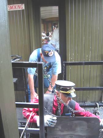
We all had reserved seats and ours were at the front of our carriage, but we spent almost all the time on the footplate outside. The couple opposite us, Miles and Cheryl from Fort Worth, also liked travelling this way, and we spent most of the journey chatting to them.
The country we were passing through was wonderful – green pastures and forested hills and lots of wild flowers, with clear mountain streams.
We had noticed a small maintenance vehicle following us, and later found out that this was the fire ‘truck’. It was well needed, as Rosie had noticed a small fire beside the line, and this truck had dealt with it.
We climbed and climbed to Cumbres Pass (10,015ft), getting more than a little soot in our eyes and hair, as we were standing outside.
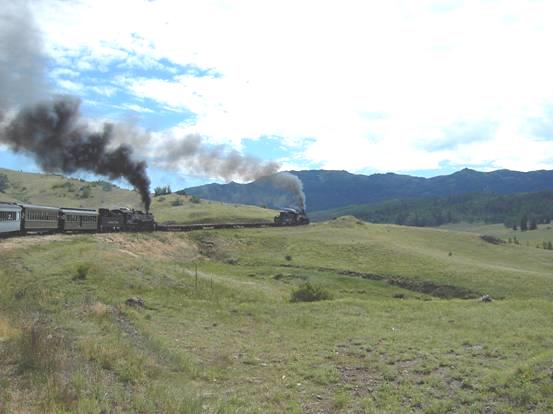
Our 2 engines chug up the hill to Cumbres Pass
We now lost our extra engine, as planned, and continued to Osier, where lunch was organised for us in the station building. This was included in our ticket price, and we had an excellent meal of turkey and ‘dressing’ (stuffing), with desert and a drink. We sat chatting to Miles and Cheryl, then climbed back on to the train. Excitement number two was about to happen! A young girl of about 12, travelling with her parents and sister in the carriage in front, was chatting to me from her footplate to ours – she had heard that we were from England. As we rounded a sharp bend in a steep gorge, the train suddenly lurched. The girl’s face said it all, as we continued twisting noisily. Adrian had the chance of a railway lifetime as he rushed to press the ‘stop’ button (unfortunately no ‘break the glass and pull the cord in case of emergency’) as we realised that something serious had happened. The carriage in front had derailed!
All the rail staff can only be praised for the next hour or so, as the driver, fireman, conductor(boss) and others got down under the vehicle to set about putting the carriage on the rails again. The volunteers (called ‘docents’ here), had the job of looking after the passengers and making sure that they were safe. The occupants of the carriage in front were moved out, and ‘Bob’ chatted to us all, and kept the curious kiddies from going onto the footplate where all the action was happening. We were lucky to be seated just where everything was going on, so could see them getting the ‘frogs’ and easing the carriage back onto the rails.
The workers getting us back on track!
The attitude of everyone was wonderful, epitomised by a little incident. There was a family with 3 young boys and a little girl of nearly two who had been travelling in the carriage in front of us. They were now sitting behind us, but it was time for the little girl’s sleep, and her special blanket was back by her seat. The volunteer alerted one of the workers, who was working under the wheels, and he climbed into the carriage to retrieve it, and peace was restored! Everyone clapped!
The carriage was finally righted, and we continued (slowly at first) on our way. The volunteers, particularly a ‘benevolent uncle’ chap called Chuck, explained to everyone, particularly the children, what had happened, and how they had fixed it.
The weather had now become windy, with a few drops of rain, so we spent the last part of the journey sitting inside, chatting to Miles and Cheryl. It was gone 6 o’clock when we arrived back at Antonito, instead of the anticipated 4.30. We said our goodbyes and wasted no time in driving on to Alamosa and finding ourselves a spot in the park for the night. We washed our sooty selves and I prepared a tasty feta and bacon salad for supper. It had been a wonderful day.
Lake Powell to Alamosa


