
Sunday 2nd October 31 miles
A beautiful day on the Kancamagus Highway. Sorted website first and sent our fourth e-mail.
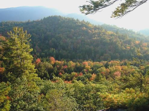
We left at 9.45 and drove along Kancamagus highway, stopping at several viewpoints.
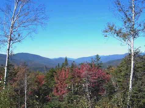
Along the Kancamagus highway
We walked the shady walk to Sabbaday Falls. The falls turned at right angles during its fall, due to a geological fault. We walked a trail by the Swift River and then visited the Russell Colbarth Homestead – a lady called Ruth had lived there in the early 1900’s. One night her husband went into town saying ‘I’ll be back soon’ and she waited 42 years for him to return – he turned up 2 years after she died!
We stopped at pretty Rocky Gorge, but there were too many visitors for us. We walked around Falls Pond behind the gorge – no people there.
We located Blackberry Crossing campsite to stay – we had intended to stay in Covered Bridge campsite opposite but the bridge was too low for campervans – there was no mention of this on the campsite leaflet!
We crossed the bridge to walk the Boulder Loop Trail at 4 o’clock. It was a very rough trail – often climbing up, or down, boulder strewn streams – we went wrong after the first marker – a bit like ‘Les Gets’ horror, but eventually found the right path and continued. It was very quiet - 3 miles of up, up, up and then down, down, down. We got back at 6.30.
I collected firewood and after supper we sat out by the fire. Adrian collected more wood – it was a mild evening and we didn’t come in until 9.30.
Monday 3rd October 129 miles
Another beautiful day with clear blue sky and the temperature in 70’s.
We ate breakfast outside.
We drove on to Conway, where we stopped at the Information to find out where the dump was, as there were none in the campsites (or any water than we could fill from). Finding the place to dump was a real feat – it was tucked away behind a hotel, down a track saying ‘no entry’! We would never have found it if we hadn’t asked a chap who was fixing his car, and he gave us clear instructions (like ‘go down the track saying no entry’)!
It was a long time before we could find anywhere to pull off for lunch. Even if a picnic site is marked on the map, we rarely find one! We did end up at a lovely place for lunch, sitting on our mats beside Chocorua Lake, with mountains up behind, and colourful trees all around. I even had a little paddle.
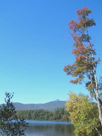
Lake Chocorua
We now continued in a generally westerly direction, enjoying the glorious colours, but not finding anywhere to pull off and explore, which was rather frustrating.
We drove through places with familiar names – Bristol and Newbury (where we had to stop of course, beside pretty Sunapee Lake, but there was no overnight parking here.)
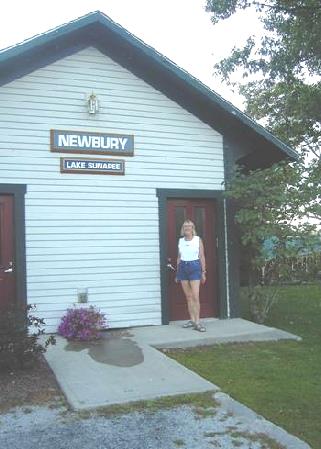
Outside Newbury Station!
Hence we carried on through Newport to Claremont, where good old Walmart had to suffice once again. At least we were able to get lots of photos printed – right up to date!
Tuesday 4th October 51 miles
It was a mild night and a misty morning, which turned into a beautiful hot and sunny day.
Adrian asked the man in charge of the plant watering outside Walmart if we could fill our water tank. The man thought that Adrian sounded like Paul McCartney (he hadn’t heard him sing!)
We drove through the attractive red brick town of Claremont and were able to log in. We were sorry to hear that dear Ronnie Barker had died. How many millions he must have made laugh!
Soon afterwards we came to the Cornish-Windsor covered bridge, apparently the longest wooden bridge in USA and the longest 2 span covered bridge in the world. It crosses the Connecticut Riverbetween New Hampshire and Vermont.
Just after this we came to Saint Gaudens National Historic Site. This was the first of 2 unexpectedly excellent and educational visits today. We explored this former home of Augustas Saint Gaudens, whose name we hadn’t known before. He was a sculptor/artist, whose work we have seen – most notably his bas relief of Robert Louis Stevenson. He had been born in Dublin to a French father and Irish mother who had emigrated to USA when he was a baby. As an apprentice, he had started by carving cameos, but had later sculpted numerous wonderful statues, (including Lincoln, and of the goddess Diana) and bas reliefs as well as sketching caricatures. At the request of President Theodore Roosevelt he designed the USA coins in 1904. He was very influential, and taught artists groups at his home here. We really enjoyed seeing his lovely work, and wandering through the gardens and grounds – right down to his former swimming hole in the ‘Blow Me Up Brook’.
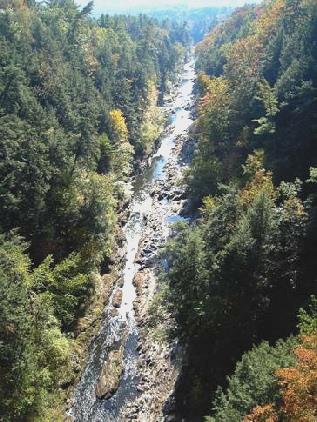
At Lebanon, we crossed the Connecticut River back into Vermont and soon stopped at Quechee gorge.
Quechee Gorge
We walked across the bridge to look down into the gorge far below. We then walked right down to the river and back and then along in the other direction to some falls by the dam. This was a ‘tourist area’, but away from the road it was fairly quiet, and also beautifully warm.
It was now 3 o’clock. We drove on, soon coming to another great stop – the Marsh/Billings/Rockefeller National Historic Site. It took us a while to fathom it out, as it had a joint entry with Billings Farm. We were enticed to watch the film which was just starting, and were really glad that we did. The film told the story of the 3 men of the title. All of them were hugely influential in the history of conservation in USA. Marsh wrote a book in 1864 called ‘Man and Nature’, which initiated the environmental/conservation idea. This place had been his family home. It was sold to Billings (3 years ago, we had come through the town of Billings, in Montana, named after him), who had furthered conservation and forest management. After his death, his wife and 3 daughters had kept the home, and then his grand daughter Mary had married Laurance Rockefeller. With his wealth and conservation ideals, the home became the first National Park in Vermont.
The Marsh/Billings/Rockefeller home
We didn’t fancy the guided tour of the home (the only way to visit), but did ask if we could wander through the gardens and view the outside of the house, which we did (not normally allowed!)
We drove on now through Bridgewater, turning on to a smaller road at Bridgewater Corner, where we found a place to pull in for the night.
Wednesday 5th October 105 miles
It was misty again, but the sun came up above the mountain before we left at 9 o’clock. The scenery and the colours were absolutely brilliant, but sadly we kept going back into fog/mist.
We drove through Plymouth and Ludlow to Grafton. Today was our day for visiting some of the pretty villages of southern Vermont, and Grafton must be one of the loveliest.
We walked around the village (pop 600), enjoying the attractive white clapperboard houses, the glorious trees and the blue sky. It was now sunny, and the temperature topped 80ºF (27ºC) today. We spoke to a chap, an artist, who was trying to dry his newly painted front steps with an electric fan! He said that that part never got any sun, and he had visitors coming today. He told us that it was unusually warm, but like us he wasn’t complaining.
As we wandered past the primary school, little boys were kicking footballs around on the grassy slope outside. It seemed a safe and happy place to grow up in. There seemed to be so much pride in keeping the village nice. There was a shady ‘village garden’ for all to wander through and relax in, and we had coffee in tiny square beside the village shop. There were autumnal effigies all around the streets, a bit like our ‘guys’, and so typical of the towns here.
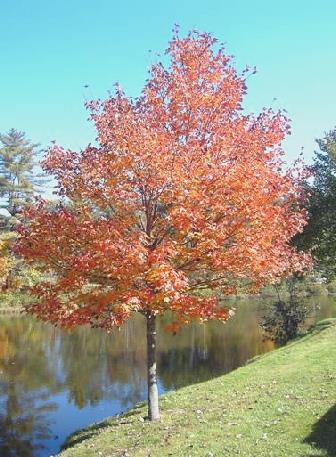
A glorious Maple
We had a pretty ride now on a sometimes surfaced road towards Dorset, another pretty village, where all the pavements were made of the local marble. We had stopped by the photogenic old quarry, apparently the oldest in USA, and had our lunch sitting under the shade of trees nearby.
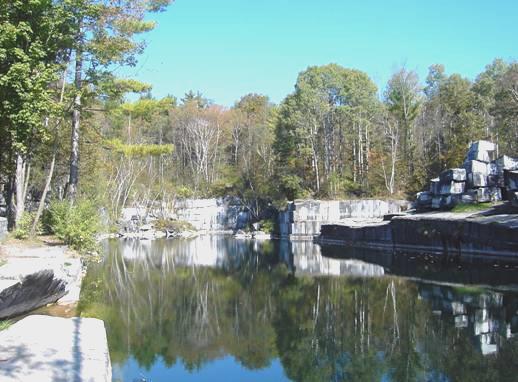
The old marble quarry
Marble pavement in Dorset
We drove on to Manchester, the actual village of which was really smart, and again with the marble walkways under the trees, and sparkling white wooden buildings.
Manchester, Vermont
We wanted to be somewhere tonight where we could sit out and have a campfire, as the weather was so good, so we ended up at Jamaica State Park, arriving at 4 ’clock.
Having got a position, we immediately set off to walk on a trail up the mountain behind us. The path started off along an old logging track, but when we had to turn off to scale the hill, we got totally lost! Will we never learn? With shades of the ‘Les Gets saga’ rearing its head, we tried to descend and retrace our steps. In doing this, we stumbled across the actual path, so we made it in the end – right up to the top, and then down to the river, where we walked along the track of an old railway line back to the campsite. It had been beautifully quiet and autumnal on our walk, and early on a large deer had dashed across our path, being chased by 2 barking dogs.
View from the top of the hill
We didn’t get back until 6.30, when Adrian soon got the barbie and the fire going. We sat out until 10.30. It was still warm.
Thursday 6th October Our 600th night in the Bam! 40 miles
There was light cloud, but we had an ‘organising time’, and by the time we moved down to the river area at 11 o’clock, the sky was blue. We had a short walk by the West River. The colours were really beautiful today. We drove south, stopping by Harrimans Reservoir near Wilmington for lunch, at a picnic area minus any tables! It was warm, windy, and there were wasps!
We didn’t leave until 2.15, and then went in search of a memorial to Brigham Young, the Mormon leader, who had been born in this area. We had difficulty in locating the memorial, but when we did, it was across a field on the outskirts of Whitingham, by a pleasant picnic area.
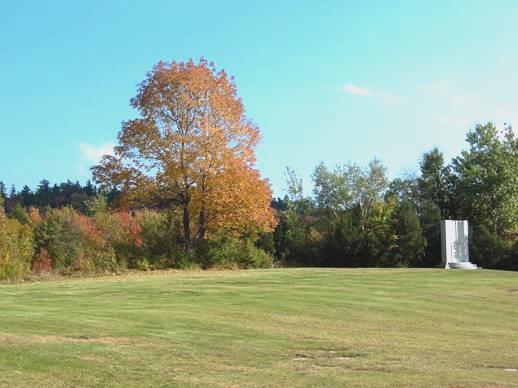
Monument to Brigham Young
Although not yet 3 o’clock, it seemed such a lovely place to stop for our 600th night in the Bam, that we pulled in. There were lovely views across colourful foliage to the hills.
We shared a bottle of bubbly as the sun went down, to celebrate our 600th night. For the first time in Vermont, we briefly saw a tiny moon low in the sky, and later lots of stars.
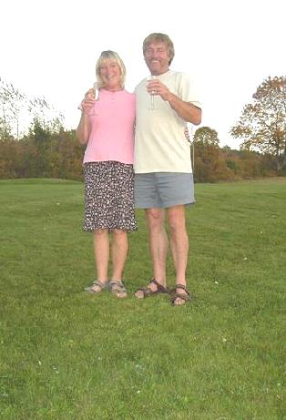
Cheers to 600 nights in the Bam
We cooked our meal on the barbie, and ate it outside, before lighting a fire in the grate with wood we found. What a lovely celebration!
Friday 7th October 65 miles
The night was really mild, and the morning damp. We left at 8.30 and followed a pretty road and soon found ourselves in Massachusetts.
We turned off to the small town of Shelburne Falls, not knowing how delightful it was. We drove on to the Deerfield River and parked. In one direction there was a pretty view to the falls (now dammed) and ‘glacial potholes’. In the other direction was the lovely ‘Bridge of Flowers’. This bridge across the river was formerly built in 1908 for a trolley (tram) route. When that ceased in 1929, the bridge had been made into a ‘flower bridge’. From early spring to late autumn, the 400 ft bridge is a mass of flowers. It was a joy to walk across it. The town had become a centre for craft shops, like potters and glassmakers, so altogether really nice.
From the ‘bridge of flowers’
The sky was still grey, and we had some spots of rain. We soon came to Greenfield, and pulled into the Welcome Centre to pick up some leaflets.
We found our way to ‘Poets Seat Tower’, Greenfield’s lookout from high on the ridge. Local poet Frederick Tuckerman reputedly sat up here to write his poetry. From the top of the tower we could see down over the leafy town of Greenfield, and to the ridges on either side. We ate our lunch on a seat near the tower. We were aware of a lot of noisy voices, and found that about 100 teenage children had arrived, seemingly on a walk. They were an unruly looking mob, many of them tattily dressed and overweight. They didn’t seem to have much enthusiasm for their walk!
We left Greenfield getting a bit lost on the way, and drove a few miles south to Deerfield. This is a historic village, being founded in the late 1600s. It was almost totally destroyed in 1704 by warring French and Indians, but recovered to be a thriving and beautiful village. There were 14 houses which you could be shown around, but we just wandered the lovely streets, enjoying the attractive houses and the lovely trees.
Delightful Deerfield
It was incredibly warm and humid as we wandered on a little trail as far as the Deerfield River and back through a farm. We had passed Deerfield Academy – presumably a fee paying college. The grand buildings occupied a large proportion of the village. The head who had come in 1902 had stayed as head for 66 years! Here the young people were in great contrast to those we had seen earlier. Many were in uniform –some lads even had ties! – and there was an air of decorum which was absent with the others.
We ended our visit in a very well stocked gift shop, trying to ignore the coach load of English tourists in there!
We drove on a few miles, and found somewhere to pull off beside the road after Ashfield at 4.30, as rain started to fall.
Saturday 8th October 50 miles
Well, that rain didn’t stop! It rained all night and all day, without let-up! At least it was still mild.
We were pleased to find that the phone logged in – first time for weeks.
So, what to do on such a wet day! We left at 8.45, following a pretty route towards Pittsfield. Here we did lots of ‘useful’ things. Today was not a day to enjoy driving, as visibility was so poor, and the road surface so wet!
We made a short diversion to call in at Hancock Shaker Village store. The Shakers are a religious group, an offshoot of the Quakers, and started in England in the 1700s. Like the Amish, they are peaceful people. Their craftwork is of an extremely high standard, as they see work as a gift to God. They believe in total equality of the sexes, but the most difficult thing to understand is that they practice celibacy. This means that the sect only continues by people being converted to their faith. It was much too wet to contemplate visiting the village, as it was made up of lots of separate buildings, but it was interesting to see the well made, and incredibly expensive, craft items – mostly boxes and baskets.
We headed off towards Lenox, a very smart looking village, where we were able to find an area to pull off onto near a large building which was being restored. It was now 4 o’clock.
We tried editing some of the video, but it was really difficult because the heavy rain made it impossible to hear the dialogue!
Sunday 9th October 96 miles
The rain continued for most of the night, but had stopped by morning and we had a dry, if grey day.
We drove back in to Lenox – a ‘gracious’ town of elegant houses. After driving around, we pulled in beside the road and found that we had an internet connection. We read on the news of the devastating earthquake in Pakistan.
We drove on to Stockbridge, which had more grand and tasteful houses. It certainly felt autumnal as we walked around, but not as cool today as the forecast led us to believe.
We drove along beside the Housatonic River, very much swollen by all the rain. We drove through the mill town called Housatonic (an Indian name meaning ‘place beyond the mountains’), where again we stopped to see the flooded and violent river.

The swollen Housatonic River
The trees were really pretty as we drove on south, soon realising that we had come into Connecticut. The first town we came to was Salisbury, another attractive town, which was celebrating its ‘Fall Festival’ this weekend. We walked around the streets, where there was a ‘scarecrow contest’ of stuffed figures, which lined the streets outside the houses. There were all sorts of stalls, including a ‘chilli tasting’ area (which we didn’t try), antiques, art displays, and even a band getting ready to play. It was all very jolly and low key, and the trees looked beautifully autumnal beside the lovely houses.
Salisbury, Connecticut
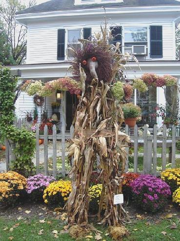
‘Fall festival fun’
Continuing on our way, we made a diversion around Twin Lakes – quite pretty but nowhere to stop – then south to Cornwall Bridge. Here it was mild enough for us to eat our lunch sitting at a picnic table beside the Housatonic River.
We drove on around Lake Waramaug, again with too many houses beside it, then through Bantam to the White Memorial Conservation Center. This turned out to be a vast area near Litchfield given over to conservation, started early in the 20th century by a man with great foresight. We were able to have a pleasant autumnal walk, thinking of Paul and Nicky, who had just sent us a message to say that they have completed walking the SW Coast Path.
We found a place to pull off on to back by the road.
We were able to edit the video more easily tonight, with no sound of lashing rain.
Monday 10th October 50 miles
We knew that we were by a substation, but it wasn’t the hum of that that disturbed us in the night so much as the traffic going by, which was heavier than we’d imagined.
It was a dull, grey day, but what the weather lacked in inspiration, we got from two excellent visits this afternoon.
We drove on through Litchfield, with its grand and lovely houses.
We headed into Hartford. Our reason for coming here was to visit two homes – that of Mark Twain, and next door to it, of Harriet Beecher Stowe. Both really influential people, who had had a profound effect on me as a child. I loved the stories of Tom Sawyer and Huck Finn, and have always equated with the wandering spirit in them.
Equally the book of ‘Uncle Tom’s Cabin’, which was read to us at primary school, so moved me that I even got Do to call her little black doll Topsy.
Both houses could only be visited by an organised tour. We went to Mark Twain’s house first (his real name was Samuel Clemens), and were shown over by a lady called Pat.
Mark Twain’s house
We had already watched a fascinating film of his life. Quite a man! It was good to see the home he shared with his wife and children, and get a real feel for his character.
The tour of the Stowe house was equally enjoyable. Our guide, Gloria, knew her stuff, and was able to imbibe some of the personality of Harriet Beecher Stowe. Quite a lady! Mother of 7 children, she wrote ‘Uncle Tom’s cabin in 1852, which had a huge effect on the slavery situation. She went on to write many more books, and also to paint. Her 3 sisters were all influential, especially in the field of women’s rights, as were her 7 brothers, who all became renowned preachers.
Harriet Beecher Stowe’s house
We came out with a lovely feeling – people had been chatty and friendly – two had commented on my ‘Route 66’ sweatshirt, and several others had chatted about England, and how much they had enjoyed living or visiting there.
It was a real treasure of a visit, but after the ecstasy comes the agony! It was now nearing 5 o’clock, and time to find somewhere for the night. Hartford is a large town, the traffic was heavy, the rain had started, and the spray made visibility difficult. We were heading for good old Walmart, way on the other side of town in Manchester (in the rain!). After the usual heartache – missing turns, losing our way (even with the GPS on the computer), we finally arrived at 5.40.
Tuesday 11th October 109 miles
It comes to something when the highlight of the day is staying at a second Walmart running and going in to buy new trainers, jeans and hat (A) and fluffy scarf and hat (R), ready for possible chilly days!
It was a grey day, with flurries of rain. We left at 9.30, and were soon able to log in. We read of the flooding in New Hampshire, the more devastating flooding in the lovely Guatemalan town of Panajachal, which really upset us, and of course the ongoing aftermath of the earthquake in Pakistan.
We drove eastwards through pretty country.
We found it more difficult than ever to find places to pull off today – everywhere seems inhabited, despite large areas of forest. We pulled into a little forested park for coffee just before crossing into Rhode Island.
We had driven through Rhode Island, and into Massachusetts before we found anywhere to stop for lunch, again in a little forested area beside the road.
We didn’t want to reach the coast today, imagining that it would be difficult to find anywhere to pull in for the night, which is why we ended up at Walmart in Halifax and went in to buy those goodies!
Wednesday 12th October 43 miles
Strong, gusty winds blew all night, and the day was wet and windy – not at all nice!
We made our way to Plymouth.
This, of course, is where the Pilgrim Fathers landed in 1620. We went into the Visitors Centre first to get our bearings, then parked on the front and had coffee, sitting in the cab and looking out to the dreary sea. You could easily imagine that you were on the south coast of England!
We drove back to see the ‘National Monument of our Forefathers’, looking a bit like a smaller Statue of Liberty.
After that we returned to view the ‘Plymouth Rock’ – supposedly the rock that the first settlers walked on to when they landed. It was under a huge purpose made shelter. As its true origin is dubious, and the whole thing a legend, rather than actuality, I couldn’t get enthused about it.
Nearby was ‘Mayflower 2’ – a replica of the Mayflower, the ship which brought over the first settlers. You could tour this, as well as the ‘Plimouth Plantation’, which is a reconstruction of the village of the early settlers. A joint ticket saved several dollars, but it was all incredibly expensive.
We decided to go for it, but I found it hard to enjoy, as it was so cold and windy that I got chilled through.
The ship was authentically done out (It was built in Brixham, England in the early 1950’s), with actors there to talk about it – had it been warmer I might have enjoyed it.
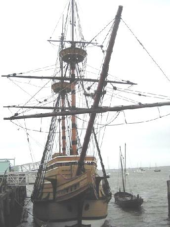
Mayflower 2
We parked by Jenney Pond – site of an early water mill, which is still there. Wrapped up in my newly purchased hat and scarf (I hadn’t expected to wear them so soon), we set off on foot to explore some of the historic centre of Plymouth. There were some nice houses, supposedly pretty old, and we saw the monument to those who died during that first winter here, but it was difficult finding the sites with the inaccurate map that we had!
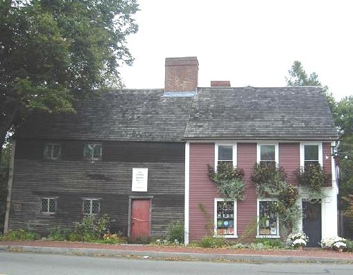
Sparrow House – an early settler’s house
We now drove out to Plimouth Plantation, and spent the rest of the afternoon there. It was an excellent visit, but much overpriced.
We started in the visitors centre, where an audiovisual ‘presentation’ set the scene of the arrival of the Pilgrim Fathers. Exhibits with thought provoking captions tried to make you see what it was all about – particularly the origins of Thanksgiving, which commemorates the thanks given by those early settlers after surviving their first year in America.
After seeing a couple of craftspeople at work, we braced ourselves to walk around the reconstructed village.
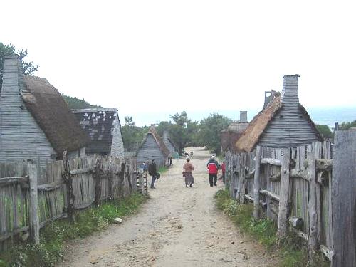
Plimouth Plantation
This was beautifully done, and you could really imagine that you were waking around a village of that time. Many of the numerous wooden cottages had actors in them who spoke as if they were those first settlers. With the insides of the cottages looking just as they might have done, and the little gardens behind looking just right, it was great fun. How much nicer it would have been on a fine day! They even had animals which the settlers would have had, and had taken pains to get the correct variety of the chickens, goats and cows (Devon and Kerry).
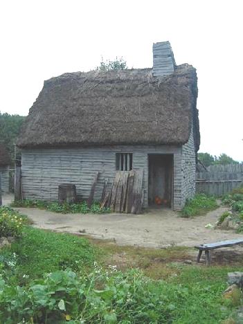
A house in Plimouth Plantation
In the neighbouring Indian village, Native Americans were living in their tents, and we warmed ourselves by their fires as we talked to them. I had not been aware of the clashes between the two cultures when the Pilgrim Fathers had arrived. Obvious when you think about it, but not the side of things that was ever emphasised.
It was now 5 o’clock. We left the park, but were directed on to the road going north, so had to find our way back south again. In the gathering damp gloom we drove south, on a road which we thought would give views of the sea, but gave none. We were heading for a state park some miles away. When we finally reached it, and had driven the long way down to it, we discovered that it was closed. Everything, it seems, closes on Columbus Day, if not before. Only the camp host was still there, while they cleared things up.
We were in desperate need of water, as we had none at all, but all the water had already been turned off.
Now we didn’t know what to do. I suggested trying the nearby petrol station for water, but generally they don’t have any in this area. We were in luck though, as this one did. Having filled the tank, it was now after 6 o’clock, and we needed somewhere to stay. We had passed a large ‘Park and Ride’ car park, so found a space there which we hope will be OK.
Thursday 13th October 132 miles
Who would have thought that a van with deliveries of newspapers would have come into the car park in the middle of the night? People drove up in their cars to collect their batch of papers to take back. Consequently there was much loud chatting and slamming of doors for about an hour! After that, the dustcart came and started emptying the huge dumpsters! Also it rained!
However, we got off early on a grey morning, and drove over Sagamore Bridge on to the peninsular, or actually the island, of Cape Cod.
Our first impressions were not good, as there were properties everywhere, with no roads down to the beach, and it was very busy with traffic. We wanted somewhere to stop for breakfast, but it was a long time in coming!
After more than an hours driving, we were able to stop beside the sea near Barnstable (twinned with Barnstaple in Devon) and have our breakfast followed by a short walk on the sandy beach.
We stopped next at the Cape Cod National Seashore Visitors Centre to collect maps. We had decided to drive right up to the end of the peninsular at Provincetown, and stop for any walks and viewing on the way back down, as there were no campsites in the park for us to stay at.
We felt that the road we were driving on could be anywhere – a bit like we felt about Florida Keys and the Outer Banks. The seashore was rarely visible, and certainly not accessible.
At Provincetown we parked by the 162ft tall monument to the Pilgrims, who had stopped off here before settling at Plymouth. We continued to the spot where the pilgrims are supposed to have actually landed. At last we could look out over an unspoilt seascape.
Now we headed into the park proper, stopping first to view Herring Cove beach, on the western side of the peninsular, and then Race Point on the northern side. They were certainly lovely beaches, but in the summer this would cost you $15 a day to park! We just put up with the greyness and the wind of autumn as we humped across the sand.
It was lovely driving through miles of unspoilt sand dunes, and we enjoyed several short walks. One was around a pond, and called the ‘Beech Trail’. It was really quiet, and we saw several small birds. We also walked what was called the Pilgrim’s Spring trail, which led to a spring in the area where the early pilgrims had first written of finding fresh water.
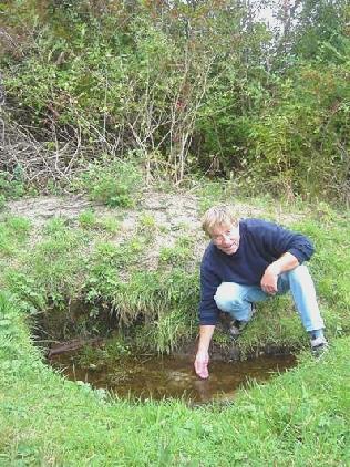
Adrian the pilgrim!
Another trail took us to the top of a small hill to look down on an area where cranberries used to be farmed.
We had many more views of the rough sea as we drove back south, and luckily the rain held off until 5 o’clock, when we had just finished our viewing.
We drove to Nickerson State Park. It was now 6 o’clock, but the fire we had looked forward to wasn’t on for tonight!
Instead we ate sushi, which we had bought yesterday.
Lincoln to Cape Cod, Massachusetts


