
Wednesday 26th August Still Bending!
Another lazy day! We spent a long time booking accommodation for our 3 nights in Boston, at the end of this trip.
Strange how days can disappear ‘doing nothing’! We enjoyed the pool, walked around to see how Jason & Dave were getting on with the Bam, and booked an extra day at the hotel when we could see that they wouldn’t be finished tonight.
Adrian made a return visit to ‘Daniel’s’, and photographed the men at work!
Thursday 27th August Melbourne all over again!
We phoned to wish Paul a Happy Birthday. We also phoned Simon and spoke to him and to Manolo.
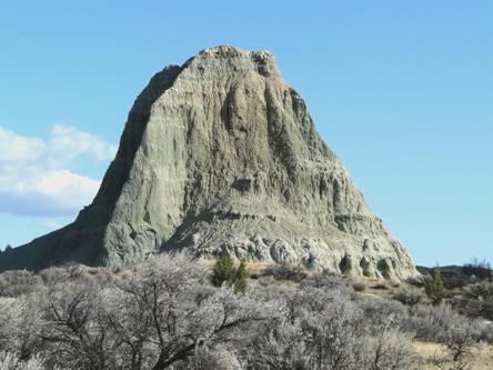
We set off early to walk to the top of Pilot Butte (pronounced boot), before it got too hot. The walk up the volcanic hill was a mile, but it was about that far to walk to get to the start.
It was already warm, but we still went for it. We found that it is a really popular thing to do (like Townsville in Oz), and there were plenty of other people walking up and down. The view from the top was spectacular – 360° of peaks in all directions.
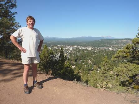
On top of Pilot Butte
We walked back down, and called in at Daniel’s, where Jason said that he hoped to be finished tonight. He let us have the use of his old pick-up truck, so we drove back to Day’s Inn, and had a last swim in the pool, and used the pleasant Jacuzzi. We said goodbye to ‘Mermaid Jody’, the fun swimming teacher, whose son’s birthday it also was today.
Our long and lanky beanpole lady receptionist (Joyce Grenfell would have had a field day with a caricature of her!) was very accommodating, and let us stay a bit longer than the 12.00 book-out so we were able to send a few emails, and eat lunch before leaving. We had turned on the TV, and watched the entourage of Senator Edward Kennedy’s body arrive at Boston.
We dropped our bags off at Daniel’s, where they had got the engine back in, and up and running. We made our way a few miles north to ‘Trader Joe’s’, a store which we had visited in Minneapolis with Jack and Rose, and found different from other American food stores, if a bit more expensive.
We dropped our shopping off at the Bam, and drove down to the ‘Old Mill’. This is an area of boutique shops, eating places, cinema etc, on the site of the former lumber mill – a bit like Swindon Railway Works village.
We had an icecream in Ben & Jerry’s, and looked around for a while, but it wasn’t really our cup of tea, particularly Adrian’s.
There were walks beside the Deschutes River in both directions from here, each over a mile long, but this filled the time in well, and was pleasant enough. It was the place to ‘float’ down the river on inflatables, and lots of people were doing it. Wild flowers, particularly orange marigolds, had been planted in swathes near the path. On one side of the river, a large art/craft market was set up under awnings, but they were just closing for the day. There were boards every here and there, telling the story of the town’s lumber days.
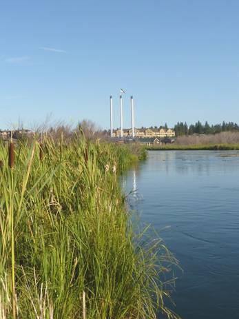
The chimneys of the old lumber mill at Bend
We arrived back at Daniel’s at 6.15 and then we heard the bad news! After fitting the engine, they had taken off the fuel tank in order to replace the pump, which hadn’t been functioning properly. We knew that they were going to do this, and expected it to be a 3 hour job. However, the pump they’d ordered wasn’t the right one – there are several slight variations. Jason had got hold of 3 others, but none was right. They had had a very difficult time phoning around anywhere and everywhere for the correct part – but the earliest that they could get was tomorrow night, with the part coming from Portland!
All of us were at a loss as what to do, but Jason had a suggestion – that we come back to his house for the night. We were very reticent, but finally agreed.
We had to wait while Jason fitted all the vehicles that he was working on inside his workshop (Simon would have loved it), and then we followed him to his house a couple of miles away.
Here we met his bubbly and lively wife Cricket, and their little girl Spencer (5). Also, there was a group of family meeting up, as Jason’s younger brother Jesse was up here from Colorado. As well as him, there was his sister Sarah, brother Gabe and his girlfriend, and her friend Monique – quite a party! Also 2 cats and a dog!
And so we settled into this unreal situation, and spent a lovely evening chatting, and enjoying the lasagne which Cricket had made. The relatives all left – Jesse to go back to Sarah’s house – he had been staying here, but now we had his room!
Friday 28th August Bending the lines
Jason went into work early, so we stayed chatting to Cricket, who was really easy to get on with. Of Polish descent, she was an energetic woman with many strings to her bow! She sometimes helped out at the garage with Jason, but also did some acting, and writing – her first play is being put on in November. She had plenty of ideas, and wasn’t shy about airing them. She suffered from rheumatoid arthritis, and had come off her medication in order to have Spencer. This had caused her a lot of trouble, which is why they only have one child.
Late morning we went back to the Bam and picked up some food for lunch. We drove off to Tumalo Falls, a few miles out of town, and walked to the falls, and on to another lot called Double Falls. Today was cloudy, so better for walking, but not so good for the photos!
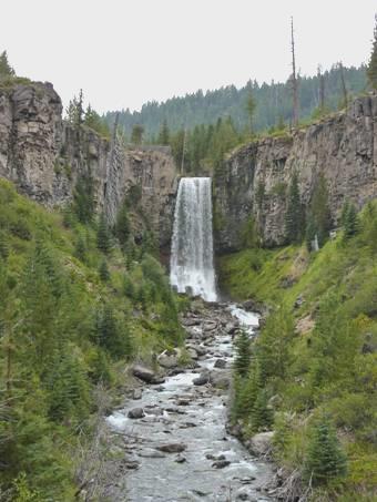
Tumalo Falls
In fact, when we drove back into Bend, and had a short walk in Drakes Park, by the river, it actually rained!
We collected the sushi we had bought yesterday, and drove up to the top of Pilot Butte to enjoy our supper! The erratic weather meant that the view looked very different, but as the sky cleared, we had dramatic views to the peaks.
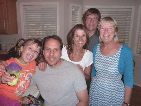
With Spencer, Jason and Cricket
We returned to Jason’s house, where we changed into our ‘glad rags’, as Adrian had bought tickets for the little theatre which is next to Jason’s workshop. Cricket had told us how good the theatre was, and that tonight’s performance was for Steel Magnolias – a play which we didn’t know, but which had been made into a film in 1989, with Dolly Parton & Shirley MacLaine. They were going to see the play next week.
What a wonderful evening! The performance was really brilliant – excellent acting, funny lines, emotional content – we really loved it! The theatre held just 100 people, so was reminiscent of our Watermill Theatre at home. In fact, looking around, nothing would have told us that we weren’t in England – just an audience of nice people coming out for the evening. A real winner!
Saturday 29th August Farewell Bend 61 miles (plus 60 Jason/Dave)
This was the original name of Bend, and finally it was true for us!
We spent much of the morning chatting to Cricket (a nickname from long ago), and to Spencer. Cricket had the idea of writing a new play, with us as the central characters – two old Brits stranded with them!
Jason and Dave finally finished fitting the fuel tank back, with the new pump, and then took the Bam for a long test drive.
We said our goodbyes to Cricket and to Spencer, and drove round to the garage to collect the Bam, and to say farewell to Dave and to Jason. They had all been so good to us, and we were really grateful. We wouldn’t have chosen this extended problem to have happened, but there have been so many bonuses – meeting such nice people, and enjoying a superb play in a small town theatre.
It was 2.30 when we left there. We made our way to Pioneer Park (where we had gone at the start of the troubles) for a late lunch, and set off out of Bend at 3.30.
We drove 16 miles north to Redmond, and then on through Prinesville, where we got fuel, and continued to Ochoco National Forest, where we soon pulled off amongst the ponderosa pines.
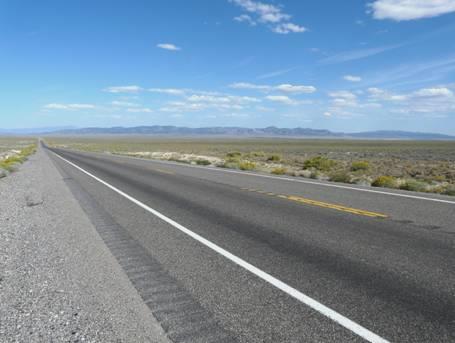
We had coped really well with being grounded for so long, but it was lovely to be ‘On the Road again’.
Several deer came down to browse, the young one leaping along.
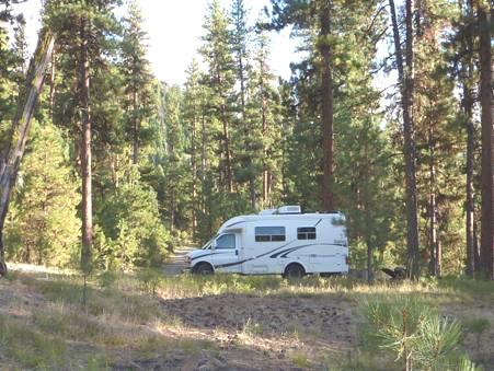
The Bam on the road again
Sunday 30th August Oh Happy Day at John Day Fossil Beds 86 miles
The warm night became very cool before dawn. We walked out amongst the ponderosa pines, as we had done last night, and left at 9.30.
We drove through superb dry, hilly country to the Painted Hills unit of the John Day Fossil Beds National Monument. There are three parts to this monument (park) and we are visiting two of them. The park is named after the river flowing through it, which was named for an early fur trader who was travelling along the Columbia River when he was attacked by Indians at the point where this river reaches it. His name was given to the whole of the river, hence the name for the monument, although he never actually came within a hundred miles of it!
We drove on through this section of the park, enjoying the wonderful striped rock formations and coloured hills. The whole area is a minefield of geological and fossilized wonders. We walked two trails in this part of the park. The first, called the Painted Cove Trail, was around hills of red, orange and mauve. The hills were made up of bentonite, a thick and sticky clay, which nothing can grow in. Iron, manganese and rhyolite colour the rocks in the different colours. It was a fabulous walk, and like all of them today, there were hardly any other people.
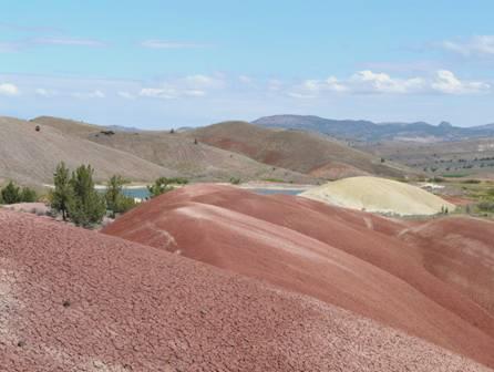
Painted Cove, John Day Fossil Beds
The second walk we did was called the Leaf Hill trail, and although we couldn’t see many fossils, the hill that we walked around contained hundreds of them – leaves from 40 million years ago.
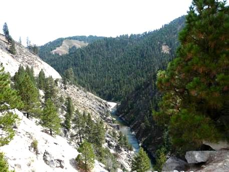
We now drove on the 30 miles to the next section of the park. Most of the route followed the dramatic dry and narrow gorge of Rock Creek.
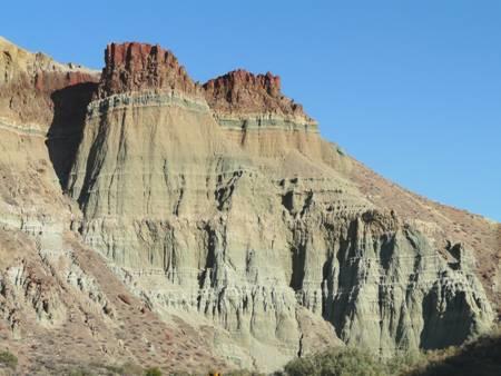
We turned off to the Sheep Rock Unit, and pulled in by James Cant Ranch, where we sat at a picnic table for lunch. After this, we looked inside the ranch house, which is now the headquarters of the Park Service, but downstairs there were exhibits about the time when James Cant had come here from Scotland in the late 1800s. We walked a couple more trails here, in the hot sun, enjoying the fabulous views of the strange rock colourations, and the farm area, with a huge barn, and many old vehicles. Originally they farmed sheep here, but later they had cattle.
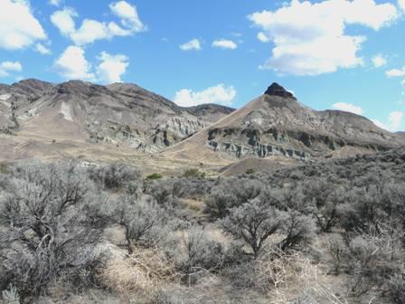
Sheep Rock
The Visitors Centre opposite had a ‘museum’ of this very important geological area, with comprehensive explanations, but far too much to take in at one go. We could look in at scientists working on fossils which had been found. It was a showpiece for the scientific work being done here. A chap in a motorhome in the car park spoke to us. We had seen him several times today, but he said that he remembered seeing us (and the Bam) at Dry Falls in Washington!
We now drove north, stopping to walk our favourite walk, at the area called Blue Basin. We walked for a total of 2 km beside a dry stream, where the rock formations at the side were an uncanny green (not blue). It is difficult to describe in words, and photos only tell part of the story.
Blue Basin
Further on up the valley, we stopped once more at what is called the Foree area. Here we walked two short trails, lovely in the late afternoon light. Once more, there were virtually no people, and it was just quiet and peaceful, with exquisitely coloured rock formations.
Blue Knob
By now it was 5.30. We had to return the way we had come, through this second section, but not all of the route went through the park, so we were able to pull in beside the road, above the rippling John Day river, for the night. Adrian lit a barbie.
Monday 31st August Along the John Day River valley 81 miles
The sun came above the hill in time to shine on us for breakfast. The night had remained warm.
We drove back the short way to view Cathedral Rock in the morning light. It was a transformation – last night it had looked nothing special, but with the sun shining on it, it looked like a tiered petticoat, with ribbon threaded through the lace.
Cathedral Rock
We drove back down the road, enjoying the different views with the sun shining on the multi-coloured rocks.
Picture Gorge
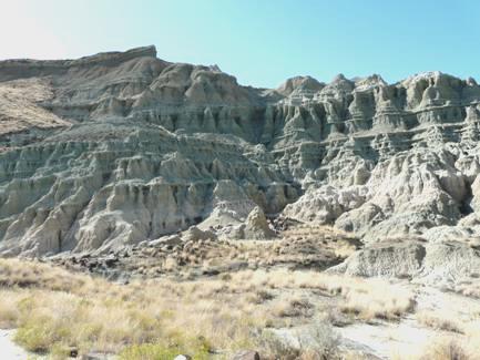
We reached Picture Gorge, so named because there are petroglyphs in it. It was deep and dramatic. Soon afterwards, we turned off to the last area of the John Day Monument that we were going to visit. This was a viewpoint down to Picture Gorge, but also of the buff coloured Mascall rock formations, which were attractive in a pale, pastel way. A jackrabbit ran off as we got there.
We now followed the John Day River through pretty country to the town of that name. Here we stopped for several things – firstly Adrian got some new wiper blades, and was surprised when the man actually came and fitted them. We didn’t have any luck with getting the new tyres which Adrian wanted, or with an internet connection – we had received emails from 3 of our kids on the phone, but had to wait until later to read them properly. We got a bit of shopping, including a sharp knife for Adrian, as his has sadly gone missing.
We found our way to the Kam Wah Chung Museum, which was a humble house which had belonged to two Chinese men in the early twentieth century.
This is a State museum, but admittance is by ticket only, from the Interpretive Centre, which was closed. You can only visit by guided tour, and the sign said next one 1 o’clock. It was only just gone 12.00 – tours were on the hour – but there was nobody about. We bumped into the RV couple from yesterday again – they said that they’d just missed the tour too, and left. We stopped to have lunch, by which time it was almost 1 o’clock. Suddenly the Interpretive Centre opened, and we could get tickets, so along with just one other couple (from Portland – he was of Japanese descent) we had our tour.
We thought that it was a strange set-up, as only a limited number of people could ever visit. The ranger took us into the home, where for 45 minutes we stood and listened to her. You couldn’t sit, or lean on the walls or furniture. Having said all this, it was interesting to see this little home, which was still full of the artefacts which had been left here after the two men had both died in the 40s/50s. One of the men had been a doctor, the other an interpreter. They both came to be highly respected members of the community, setting up a place where the many Chinese who had come to work on the railroad and in the mines could come for food, lodging and help.
By the time we left, it was 2.15. We drove the short way to Canyon City – once the largest town in Oregon, but now a small place with an attractive Main Street, giving a feel of its former days. With an internet connection, we read our emails, and sent one back to the ‘kids’, being too late to phone.
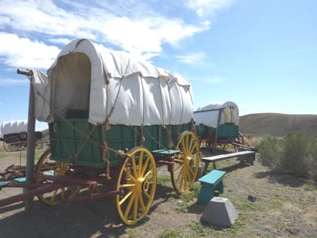
Continuing on our route, we next came to Prairie City, another attractive town, with a railroad museum, but it wasn’t open on Mondays. Adrian did get a look at some of the rails a bit later, when we walked through a bit of Wallowa National Forest on a short trail to part of the former line. We’d already stopped to look at a covered wagon beside the road, like those used on the Oregon Trail, which had passed close to, but not through here.
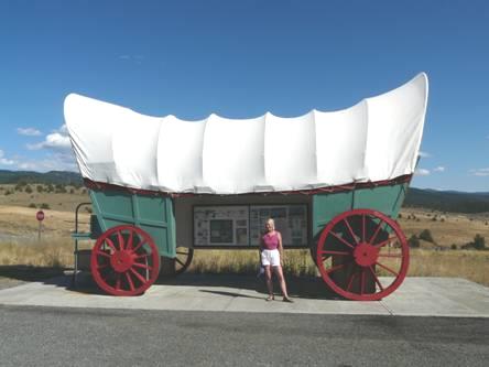
On the Oregon Trail
Just after going through Dixie Pass (5279 ft), we pulled into Dixie Forest campsite.
Later Adrian lit the barbie but the day had cooled down, so he could have just lit the fire. After eating our steak from Trader Joe’s, he did light the fire. It was really quiet here, and we enjoyed our first campfire for nearly two weeks.
Tuesday 1st September A giant gold dredge and the Oregon Trail 149 miles
Another fine morning. We left at 8.45 and continued on the road to Baker City, through forested, uninhabited hills. We looked at the so-called ghost town of Whitney, but the log cabins of the former small lumber town, which ‘died’ after the railway closed in 1947, now appeared to be lived in.
Sumpter was more interesting. The town itself was a delightful outback town. There were two things of interest here. The first was the steam railway, but this was only open at weekends. Close to it was a huge gold dredge – 1,240 tons – which was used from the 1930s to 1950s to dredge gold from the Powder River.
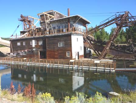
The Sumpter valley gold dredge
Adrian had a field day here! You could walk right around the dredge, and go inside it, and there were all sorts of artefacts around to interest him. We have seen dredges previously in the Yukon and in Australia and they all work on the same principle of floating in a small lake, digging gravel out from the front, sifting it for gold-bearing rock and then dumping the spoil behind. So slowly they move about the area always in their own little manmade pond. This one despoiled 1600 acres of land, leaving a desolate gravel landscape behind after extracting $4.5 million of gold.
The day had already become hot. We followed the pretty valley of the swirling Powder River to Baker City. Here Adrian tried to get new tyres again but no luck. The town had a nice Historic Centre. We drove a few miles out of town to visit the Oregon Trail Interpretive Centre, on the top of dry and treeless Flagstaff Hill.
The museum was of the usual high standard, with superb life size exhibits and information portrayed in many different formats, giving an excellent impression of what it would have been like to travel the 2,000 miles across America to find the ‘land of dreams’ in the 1840s and 50s. One in ten people of the 300,000 people who travelled the trail died en route and those who survived had an incredibly arduous journey.
Wagons on the Oregon Trail
We drove on through the pleasant little town of Haines to La Grande. We drove on through flat, fertile country, stopping near the Grande Ronde River just before Elgin. As we drove a short distance along the road we had turned off to, 3 deer leapt across in front of us. On our return, we passed a snake on the road. It was still very hot – we were glad when the sun went down!
Wednesday 2nd September Along the Wallowa Valley 107 miles
We left at 8.30 and drove through lovely outback Elgin, and on through flat, agricultural land until we reached some very arid hills. We descended through a steep gorge to Minam, following the delightfully bubbling Minam River, which now joined the Wallowa River. We drove on through the pleasant but sleepy small town of Wallowa, and then on to Lostine (lost in time, Adrian thought!) Just beforehand, a red fox with a very white tail had shown itself.
At Enterprise we were able to get water. We shopped in an uninspiring Safeway, buying firewood from Canada!
The valley was overlooked by the beautiful but unforgiving Wallowa Mountains. We came to the town of Joseph, named for Nez Perce Chief Joseph, who we have learnt so much about. This is Nez Perce country, and it was the Nez Perce who had been so invaluable to Lewis and Clark on their expedition. Joseph was a pretty, arty town.
We drove on from here to Wallowa Lake, a glacial lake six miles long, with high banks of moraine on either side, making it appear dammed.
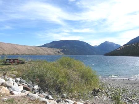
Moraine dammed Wallowa Lake
We didn’t have much luck there! First we stopped to see the grave of Chief Joseph – father of the Chief Joseph who we knew about. At the near end of the lake, we pulled into the County Park to have lunch, but it became more of an endurance, as it had turned really windy, although still very warm. There was a swimming beach here, which had pleased me, until I saw how rocky the shore was, and that the wind had made the water very choppy.
We drove down to the far end of the lake, where there was a vast State Park. We finally found the beach area, but as the water was low, it wasn’t at all enticing.
The area here was quite ‘resorty’, but there was a cable car which could take you to the top of Mt Howard, from where there were easy walking trails. Although quite pricey, we had decided to go, when I must have stepped down awkwardly from the van, as my left foot suddenly felt quite painful, as if I had ricked it. It seemed silly to pay money if I wouldn’t be able to do any walking. We drove back to the other end of the lake, where I opted for a swim, feeling quite hot and bothered by now. We braved the rocky beach and the cool water, and I felt refreshed afterwards, but Adrian wasn’t so keen!
We now continued on our route – part of the Hell’s Canyon Drive. The next part felt like driving on a private forest drive, through steeply forested slopes, on a winding road. There was no habitation at all.
When we reached Blackhorse forest campsite, beside the Imnaha River, we pulled into a pleasant spot by the rushing river, with tall forested slopes all around.
It was really quiet, apart from the rushing stream. Later we lit a fire, and cooked Canadian red snapper. A pocket gopher pushed up soil, like a mole, and we sat out until 9 o’clock, when the almost full moon was just rising.
Thursday 3rd September Hell’s Canyon from above and below 147 miles
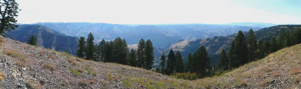
The sun had just come above the high slopes when we left at 8.45. We drove the few miles to the Hell’s Canyon viewpoint. The first sight of it was breath-taking – the misty blue canyon with the Seven Devil Mountains in the distance, and the absolute quiet. We stopped for quite a while at the official viewpoint – nobody else about. 1½ miles down, but out of our view, was the Snake River. It is supposedly the deepest canyon in U.S. It made us think of Copper Canyon in Mexico. Oregon grape, with its pale mauve elderberries added colour to the magical scene.
Hell’s Canyon from above
We now wound on down through the deeply forested , steep slopes, following North Pine Creek, until it joined Pine Creek, and from here we made our way to Copperfield – a town which had appeared, and just as quickly vanished again, in the late 1800s.
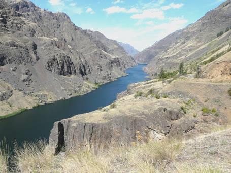
Here we crossed the Snake River, to drive up on the Idaho side to the actual Hell’s Canyon dam. We stopped by the dammed Snake River, surrounded by dry hills. There were huge fish in the water, but nowhere to swim.
The road now wound for 23 miles up the canyon – they had had to build the road before they could build the dam in the 50’s. It was a spectacular journey, with the high vertical basalt cliffs, dusted with pale yellow grass on the slopes, and dotted with bright yellow daises and the occasional tree, where there was enough soil.
and from below
When we reached the dam, we drove across it, and could see the un-dammed and wild river beyond. As this was advertised as a Recreational Area, I had imagined some sort of resort here, but there was just a small Visitors Centre, and access to boat trips – but nothing around when we were there.
We drove back a short way, and stopped at what must have been a former site when they were building the dam. There was nothing there now – just another motorhome, the owner of which drove by and asked us how we were doing with the fishing. He couldn’t comprehend that we didn’t fish! He said that the fishing wasn’t good, although there were a lot of large carp.
It was very hot, but really windy. We managed to sit outside to eat lunch, before having a short swim from a previously made access, which was now most unsafe!
We drove back to Copperfield, stopping by the park beside the river. A man and woman went to jump from the bridge into the water. The man jumped, but the woman never did!
There was a second dam here, called Oxbow, and another 12 miles further at Brownlee. We followed down beside the river and crossed by the dam, so were now in Idaho again. We were still surrounded by hills – steep, dry, brown and treeless hills, but with an austere attraction.
We intend driving through the south-eastern corner of Oregon in a few days time. We had loved the Oregon coast on our first trip in the Bam in 2002, and now we had really enjoyed seeing the fantastic scenery of the inland part.
We continued to Cambridge, where we stopped to get petrol.
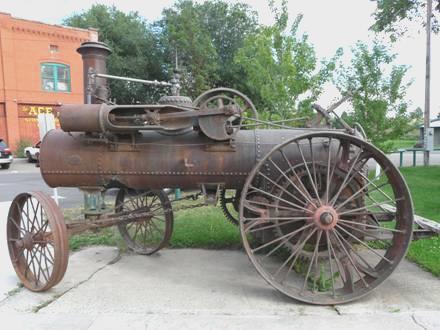
We were now driving through lower but still dry and hilly country. At Council, a lovely little outback town, there were two old steam engines in a small square, which Adrian took delight in.
One of the old Steam Engines at Council
On driving around the town, we followed signs, and came to an unkempt ‘Community Park’, with RV facilities, which seemed a good place to stop. It was 5.30, but 6.30 if we kept local time.
Later we had a barbie, and sat out at the picnic table to eat our meal, as the sun went down, and the full moon rose.
Friday 4th September More dramatic canyon country 171 miles
We ate our breakfast outside, surrounded by pretty blue chicory flowers, which must have been closed up last night. The town of Council seemed to have got it right, it did appear to be a very nice place. It even had a large recycling shed in the park.
We continued north to New Meadow, where we joined the Payette River Scenic Byway. Although we did go through areas of forest, the first part didn’t seem ‘scenic’ at all, being through flat, agricultural land. At the mountain resort of McCall, we pulled in to a small Rotary Park by Payette Lake. There was a swimming area, which we could have made use of later on.
After Cascade, the road became very winding as it followed the turbulent Payette River, and now we really could call it scenic! Traffic was heading north fast and furious, presumably leaving Boise for the long Labour Day weekend.
At Banks, we turned off onto the so-called ‘Wildlife Canyon scenic byway’. This followed the Middle and then the South Payette River, both of which were even more turbulent, and the gorge was even deeper. People come here to kayak in the white water. We felt quite naked with no kayaks, and the road didn’t really cater for us, as most stopping places were for river access, and finding somewhere to stop for lunch was really difficult. We finally pulled into a campsite just before the end of the road. We didn’t see any wildlife, but the road was generally quieter.
Wildlife Canyon scenic byway
We now joined the ‘Ponderosa Pine scenic byway’, making a loop back towards Boise (pronounced boyzee). We had originally intended going further, but our hold up in Bend has meant that we are having to shorten some of our proposed route.
We hadn’t expected much of this road, so were surprised to begin ascending steeply through dense pine forests to the first of two summits at over 6,000ft. At the second summit, More’s Creek Summit, we actually had a few drops of rain, but the day remained hot and sunny.
We passed one or two forest campsites, but nothing suited us, and then we came to a large rough area opposite a day use area, and beside small Mores Creek. Although still early, we pulled in, as we didn’t want to end up near a large town on this busy weekend. Adrian re-dammed the stream, and I cooled off by lowering myself into it, but it wasn’t deep enough to do any more.
About to cool off in More’s Creek
Dozens of RVs of all sorts were passing on the unmade road, all with ATVs and other vehicles. Again we felt quite out of it!
There were some trails leading from the day use area opposite, so before supper we set off to walk them. They supposedly told of the gold mining and logging times of the area. We found that they had been sadly neglected – there were no markers, and no seats, as on the plan. We just had to think of it as a nice stroll before coming back to light the barbie. A chap came round in a car, selling firewood, so after eating our steak, we lit a fire, and sat out in our isolation, enjoying the full moon.
Saturday 5th September Film set towns and 4 new Tyres and Adrian! 104 miles
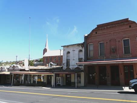
We drove the short way to Idaho City – population now supposedly 450, but after gold had been discovered nearby in October 1862, there were over 6,000 people, mostly men, by the following summer! For a while, it was the largest town in the Pacific Northwest.
The delightful little town still had a look of those days although it had burned to the ground in its early days, and many of the buildings had been rebuilt of brick, not wood. The sidewalks were still wooden, and at this time of day it was really quiet, but we could imagine that it became quite busy as a tourist town later on.
After wandering up and down the atmospheric Main Street, we went into the small Visitors Centre. They had some lovely old black and white postcards of the area’s early days, so we bought some. The old chappy in charge, who we both thought was just like Les Smart, took an absolute age to serve us, and scan in each card. Adrian tried to make conversation, and asked if he had always lived here, to which he answered that he’d lived here 7½ years. Before that, he said, he lived in Las Vegas, but his ‘lady’s son’ lived here, and that’s why he’d come. A bit different, we said. ‘Yes, no gaming machines’ he replied. We chuckled to think of this old chap, who we had thought was an old time miner, had come here from Las Vegas!
He had given us a (badly photocopied) map of the town, and suggested that we visit the pioneer cemetery, which we‘d intended doing anyway. Getting there was a feat in itself, and entailed several dusty side roads. Most of the remaining gravestones were modern ones, but even they were interesting. One had an added engraved plaque, saying something like ‘sorry mate, you weren’t born in 1957, it was 1958, my mistake’!
It is estimated that of the first 200 graves dug here, only 28 had died of natural causes! It certainly seemed like a wild place then.
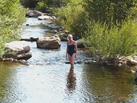
The road on from here to Boise was far more attractive than we’d have hoped, following the forested canyon of More’s Creek. We stopped at a delightful spot, and after coffee, had a ‘cooler’ in the deep part formed by a homemade stone ‘dam’.
The valley gradually became drier, until near Boise it was very arid. The sheer dark basalt cliffs made it really attractive, especially with the contrast of the pale yellow grass covering some of it. We saw rock climbers, and thought of Tom. More’s Creek had been dammed to form Lucky Peak Lake, a playground area for the town.
Boise, the capital of Idaho, is a large but pleasant town. We drove into it, on a trail of tyre firms, as Adrian still wanted to get new rear tyres for the Bam. Most didn’t have what we needed, and then the one that did had some which were far more than we wanted to pay. We went off to busy ourselves with useful things – shopping, washing, having lunch – while Adrian thought things over. He decided that it would be foolish to carry on without getting new tyres, so we faced the inevitable, and went back to get them fitted. Four new rear tyres didn’t come cheaply, but the men worked really quickly and efficiently and by 2.30 we were on our way again.
We drove on into the centre of Boise, right past the capitol building, but then took the motorway out. We turned off into flat, agricultural land, near the border with Oregon. The small town of Notus really looked lost in time. At Parma we stopped to see a replica of Fort Boise, a Hudson Bay Company fort, which had been very supportive to the people on the Oregon Trail, who had stopped off here. There was a statue of Marie Dorion, who we have seen quite a lot about. She was an Indian woman who overcame many hardships with her two infant children, and survived attacks on her journey through this area. The annoying thing to us was the vicious mozzies which attacked us, so although you could overnight in the park for $10, we didn’t!
This was a big onion growing area and hundreds of wooden crates were piled up waiting by the railway station.
We now took a bit of a wild goose chase of a route, as Adrian wanted to drive through yet another town which bears his name, just over the border into Oregon. We finally found our way, and crossed the Snake River to the tiny outback town of Adrian, which, like Idaho City was better than any film set! We snapped many a photo of the crumbling buildings, and especially liked the ‘City Hall’ – a wooden building the size of a dunny! Someone had a sense of humour!
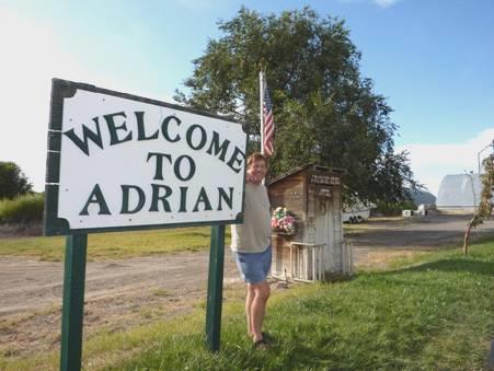
Adrian in Adrian, Oregon
Driving just out of the town, we found a pleasant place to pull off beside a large meander of the Snake River and sat and enjoyed the rural atmosphere, with just the sound of frogs or cicadas, and a distant heron, and the smell of the new rubber tyres! We sat outside until late, watching the full moon rise, and the dozens of swallows swooping overhead.
Sunday 6th September Two nice surprises in a long journey of nothingness 246 miles
The night had been really warm. We sat outside above the swirling Snake River to have breakfast, while the dozens of swallows swooped continually over the water, and a great blue heron flew down. It had been a lovely spot, with a bare ‘butte’ up behind us.
Our route south went through Idaho for about 40 miles, with empty arid hills with outcrops of basalt. Once back in Oregon, the land became flatter, but still very remote.
We stopped at the tiny habitation of Jordan Valley to have coffee in a small watered park. It felt cool, with the wind was blowing strongly, and a truck had its engine running the whole time, then two people arrived with six dogs, so we didn’t linger!
A sign said ‘next fuel 100 miles’! That was at the border with Nevada.
In this tiny, remote place, we tried for an internet connection, as I had wanted to phone Simon in their new home near Geneva. We had tried earlier without luck. Just as we were leaving the ‘village’, we got a good connection, and we were able to phone Simon, and also Tom, to wish him a Happy Birthday, and Emma. None of them would be able to imagine how remote we were!
A few miles on we saw a sign saying ‘Lewis and Clark site’. As we were well off their route, we wondered what it was. The next sign said ‘Charboneau grave – 3 miles.’ This was on a gravel track, but we followed it anyway. We were expecting it to be the grave of Sacagawea’s husband, but when we finally reached it, we saw that it was the grave of Jean Baptiste, Sagacawea’s infant son, who had travelled on the Lewis and Clark expedition with his mother.
After the expedition, Clark had educated him, and he had travelled to Europe, learning to speak several languages. After 6 years he had returned to America, gone to the Californian goldrush, and then come back to this area. He had died of pneumonia in nearby Innskip ‘Station’ in 1866.
Grave of Jean Baptiste Charboneau
We both felt very emotional at finding his final resting place. Adrian remembered that he had died in a remote part of southern Oregon, but hadn’t made the connection. I wondered if my great great uncle William Lawson had come across him in the Californian goldrush.
It seemed a suitable place to stop and have lunch. Just as we were pulling away, we noticed some rubble from a former building near the humble dwelling opposite. We then saw a fallen down sign, saying that this had been Innskip Station – a fortified dwelling dating from 1863, which had served as a hostel. The three houses here are now called Danner.
We returned to the road – so glad that we had bought the new tyres yesterday, or Adrian wouldn’t have attempted the bumpy drive. We continued through the treeless landscape, crossing the Owyhee River. This was named after two Hawaiian ‘scouts’, who had been killed by Indians, ‘Owyhee’ being ‘Hawaii’. Nearby was ‘Rome Station’, which was no more than an Australian roadhouse! In fact we were often reminded of remote parts of Australia today!
A few miles on, at Burns Junction, we turned south. All there was here was a small petrol station! (It wasn’t a hundred miles from Jordan Valley, so perhaps it didn’t have petrol.)
After driving south through the increasingly bleak landscape, we crossed into ‘Pacific Time’. We were in the absolute middle of nowhere, with no houses, so we wondered why the timeline wasn’t at the border some miles south.
We came to Blue Mountain Pass (5293 ft). By now there was just scrubby grass. We reached the tiny town of McDermitt, at the border with Nevada. We immediately noticed casinos, but there was very little else. It was still flat grassland with distant barren hills on either side, and not a tree in sight! In fact the only trees we saw were by the occasional isolated dwelling.
A sign read ‘Just ahead – Winnemucca – 1 hour’! It was 74 miles, and there was nothing in between!
We now needed somewhere to stop for the night, but there were no suitable places. The flat valley was horribly dusty and unwelcoming, and the road was busy, for one which went nowhere! As we neared Winnemucca, we turned off in desperation on a side road which said to ‘Regional landfill’ and ‘shooting range’. The narrow tarmacked road wound up into the hills, which was far more pleasant than down in the dusty valley. We passed the ‘landfill’, but couldn’t find enough room anywhere to pull off the road. I had joked when we’d turned off that the road was going to some masts right on top of the hill. As we pulled into an unlevel but manageable area, we realized that the increasingly badly-serviced road was going just there!
We could see the masts up above us, and the bare hills all around, and down below the dusty valley. The warm wind was blowing strongly, but we were happy in our isolation - 5500ft up.
From our spot way above Winnemucca
Monday 7th September ‘The Loneliest Road’ 246 miles
The wind dropped, and the night was not as cold as we’d expected. We left at 8.30 and descended the 3 miles down the hill. With the clear blue sky, it looked lovely down in the valley this morning – it must have been the windy weather yesterday that had stirred up all the dust.
We drove through the nice looking town of Winnemucca to the I80 east. The bare mountains looked stunning against the blue sky. We travelled effortlessly for about 100 miles, turning south at Carlin at 11.15, so that we could loop back to Lake Tahoe on the border with California.
The road south was just as empty – mile upon mile of wilderness, with mountains in the distance, although the yellow flowering sage brush added a bit of colour. This quiet, straight road seemed an ideal time for me to have a drive. We pulled into the side of the road to swap drivers, and I drove until the only pull-off in the 90 miles, which turned out to be a rest area, so we stopped to have lunch.
When we reached Route 50, we drove back 3 miles to the former silver mining town of Eureka. The population now is 650. We walked a bit of the Main Street, deserted on this Labour Day holiday, and Adrian particularly enjoyed some of the crumbling old buildings. The fire station was enormous for such an isolated town.
Eureka
While here, we received a message to say that sadly Adrian’s old work colleague Les Smart had died.
We now headed west on Route 50, dubbed the ‘loneliest road in America’. It certainly was a road going through a whole lot of emptiness – just a wide, flat, scrub covered, yellow-tinged valley with distant hills in shades of grey. The road had earned its name in the 1980s, after Life magazine had run an article on it, bemoaning its lack of theme parks and roadside attractions. This had now become its attraction!
‘The Loneliest Road’
Around 4.15 we reached Hickison Petroglyph Recreation Site – a nice surprise, as it had a free campsite. There were a few small pine trees, and views back to the remoteness that we had driven through.
There was also a short trail amongst the pink strange shaped rocks to view some petroglyphs. These were sadly crumbling away with the rocks, and had been added to by modern graffiti ‘artists’, and the explanatory leaflets were missing, but it was a pleasant early evening walk in the arid desert.
We had a lovely evening, lighting the campfire, and sitting out until 9.30 under a star filled sky, with the slightly squashed moon shining down. It was really quiet.
Tuesday 8th September Colourful desert scenery as we continue on the lonely road 134 miles
The sun was shining down on us at 7.00 am, but it was still cool, which wasn’t surprising, as we were at over 6,500ft! We still ate breakfast outside, and the day rapidly warmed up to become very hot again.
We enjoyed the beautiful clear views as we drove on along this empty road. We drove through a short section of the Toiyabe National Forest, where there were a smattering of pinyon and bristlecone pine trees, and going over Bob Scott Summit (7,267ft) and Austin Summit (7484 ft).
Very soon we came to the small town of Austin – population now about 250, but during its silver mining days (discovered 1862) it had numbered 10,000. This was the only habitation we passed today, apart from 3 or 4 isolated ranches. It was situated at 6,600ft, on a hill side, and was quite delightful.
Austin
Our first interest was to get an internet connection, as we wanted to contact Alice, who we hope to see at Lake Tahoe. Even in this remote area, we were finally lucky. We received a lovely email from Joe & Irene, recently returned from Vancouver Island, and telling us that is has been wet there for some time, so the fire danger is over. When we were there it was so hot, and we had no rain at all. Austin was too interesting looking to not stop and have a walk up and down the Main Street. There were 3 pretty churches with spires, and a host of atmospheric buildings. It would seem to have become a place for ‘alternative’ people to live – those who are happy to be far away from it all. Artefacts of former days lined the street, and the bars, and businesses were covered with interesting things. Outside, tomatoes and peppers grew haphazardly in the tiny ‘gardens’ by the street. Turquoise stones seemed to be a speciality, and one rock/jewel store was painted a bright turquoise colour. A couple walked by with cropped hair – hers bleached white and his turquoise!
The brick courthouse doubled as the place to pick up leaflets – we got some on the surrounding area, including one on last night’s petroglyphs. Upstairs we could walk into the courtroom, looking like the one in Philadelphia where the Declaration of Independence was signed.
We were pleased to see that a restoration project had been started to restore some of the buildings. We looked through the window of a shop and a garage, both looking as if they hadn’t been entered since the day they had closed.
Having soaked up all this atmosphere, we drove to the end of the town, where there were four attractive large cemeteries. We took a road down to see the former railway building and turntable, both featured on the ‘artists impression’ map which we had of the town. We realized that the railway hut didn’t exist now, and all that remained of the turntable was a wall, although it is on the register of historic places!
Now we set off across more of the lonely desert. It really was a treat of different colours and landscapes. This route had been used for the early overland trails. At New Pass, we stopped by the rubble of a building which had been a station on the John Butterfield Trail, and we had lunch by a site at Cold Springs telling of the Pony Express trail. Both trails were short lived, being superseded by the Telegraph Line, which was then made unnecessary when the railway came. This land is absolutely without shade – we pulled out our sunshade in order to have lunch – so would have been unforgiving terrain for the riders. Many stories abound of the problems that were come across, and the dangers encountered.
Some miles on, amidst ever changing scenery, a track led off to Sand Mountain recreation site. We decided to investigate, driving the roughest corrugated mile ever. Ahead of us, amidst hills of banded colours, mostly covered by a darkish hue, stood a vast white sand dune 2½ miles long.
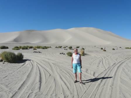
Rosie by Sand Mountain
There was supposedly a campsite here, and it would seem to be a place for off- roading vehicles to come, but today there were few people about – just one or two attempting to climb on the dune. It was far too hot for that, and the setting – just dusty sand and not an atom of shade, didn’t entice us, so we drove back along the bumpy track and continued on our way, passing huge dried lakes. People had found stones, and written their names beside the road.
Suddenly I noticed lots of large boulders on the hill by the road, and we came across Grimes Point –another petroglyph site. The sun was still hot as we walked a trail around these numerous boulders, with dozens of petroglyphs etched into them.
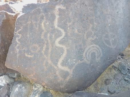
Petroglyphs at Grimes Point
We thought of staying the night here, but a track led on for a mile or so to another lot of petroglyphs and a hidden cave. We took the track to Hidden Cave, which wasn’t as bad as the previous one, and thought that it would be quieter to stay here.
Later we had a barbie, but sadly the mozzies drove us in – even in this arid situation. It was still warm when we looked out at the stars at bedtime.
Wednesday 9th September 09-09-09 Things to try us, but a lovely place beside the lake to end the day 92 miles
At 7 o’clock we set off to walk the trail to the Hidden Cave – it had been too warm last night. It wasn’t the most successful walk! Mozzies bothered us again, and after the first marker, by more petroglyphs on a rock, we never found the right path! I was suspicious all along, but we continued over the very rough terrain, up and over a steep hill. The map had made it look so simple – just a loop with the few markers on it – but we had still taken a photo of it. It turned out to be quite inaccurate, and once again, there were no explanatory leaflets. Only when we got back in sight of the Bam, did we rejoin the path, and so saw the final two cave entrances. Many other people must have had trouble too, as there were plenty of footprints the way we went. We did have a big excitement though. Towards the end of the walk, I saw a coiled up snake right in front of us. It was a rattlesnake! We watched as it slowly slid away and coiled up again, and I took lots of photos.
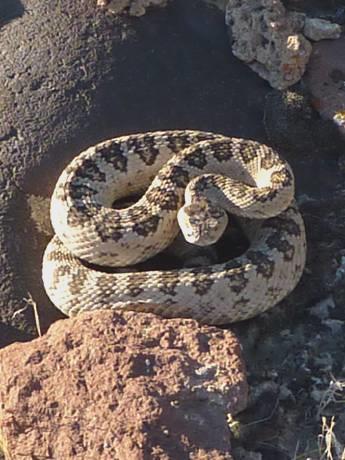
An unexpected surprise!
Our half hour intended walk had taken us an hour. We drove back to the Grimes Point carpark to have breakfast, so that we could sit at a picnic table – even then there were mozzies!
We left at 9.15. We had heard just one or two of the tremendously loud planes from the nearby US Naval Air station – it seemed like an earthquake.
We soon came to the town of Fallon – the first town of any size for days. Here we had luck in phoning all four of our kids, and were able to wish Tom a Happy Birthday. The rest of the morning was spent doing the essentials. We shopped in Safeway before driving off to the ‘Fairgrounds’, where there was a place to dump and get water. They were watering the park by ‘flood irrigation’, and most of it was under water!
Now we wanted somewhere for lunch. The first park we tried had no tables in the shade. The second one didn’t either, so we decided to put our own chairs in the shade of the van. It wasn’t a peaceful stop! On a nearby railway siding, several men were taking it in turn to ‘sledge hammer’ something on one of the trucks! Then, as we went to sit out, a chap came to cut the grass on a big sit-on mower, right in front of us!
By the time we’d stopped to get fuel, and for Adrian to photograph a ‘hotted’ school bus, on huge wheels, it was well after 2 o’clock, and we’d driven just 18 miles!
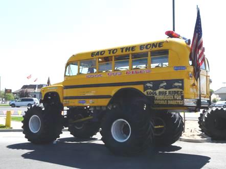
How silly can you get?
We now headed for Fernley, the last of the ‘towns’ on the ‘Loneliest Road’, before heading for Pyramid Lake. The whole area around the lake is on a Paiute Indian reserve. The drive there was through absolutely barren desert. The sight of the deep blue lake, contrasting with the bare pinkish hills was quite stunning – beautiful in an austere sort of way. We had followed the Truckee River, which flows from Lake Tahoe to Pyramid Lake.
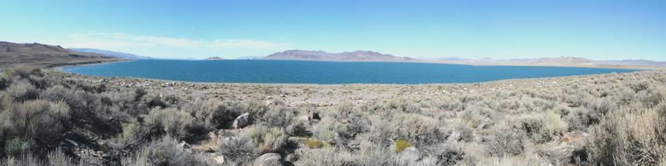
Pyramid Lake
We stopped at the Paiute Museum in Nixon, mostly to enquire about permits, as you needed one to camp or to swim. The one man in the museum was on the phone. He indicated for us to look around, which we did, but he was still on the phone half an hour later, so we didn’t find out about the permits.
We started driving up beside the lake, and pulled into a sort of beach area to have a swim. Almost immediately a ranger pulled in, and asked about our permit. Adrian told him the story, but he couldn’t sell us a permit. We had to drive on to Sutcliffe, and get one there. We headed that way, passing the turn off which we intend taking tomorrow. At Sutcliffe, we took ages hunting for the Ranger Station, and when we finally found it, it was closed, as was the nearby store! We were about to give up, when we drove back to the bar, and here we were able to purchase our $10 permit.
Now we wanted our swim! The first beach we tried had water so yukky that we didn’t stay. We started off south, and drove on a long track to another bit of beach. The location was lovely, but the beach at the edge of the water had very slippery solid mud, so after trying for a long time to get in, we gave up! We ended up by driving right back to the first place we had stopped at – Blockhouse Beach, and there we did have a delicious swim in the warm water, from a deeply shelving beach, so no grot. I was happily swimming, when I saw something floating in the water – and realized that it was Adrian’s sandal! I gallantly rescued it, before continuing with our swim!
This lake is renowned for the prehistoric Cui-ui fish, which are only found here. There are a lot of birds too – Anaho Island is a breeding ground for the American white pelican. We also looked across to Pyramid Rock, which the lake is named after – Fremont had seen and named it in the 1840s.
In our isolation we lit the barbie, and enjoyed this idyllic situation, as different colours lit up the hills as the sun set. It was still really warm, and we managed our meal before the mozzies interrupted us .Adrian then lit a campfire, which was magical, but even then, night-time mozzies arrived, and when we went back inside, a whole lot of flidgies joined us too!
Thursday 10th September Bonanza! 138 miles
There was light cloud in the morning, so we didn’t get the lovely contrast of the blues of the lake and the reds of the bare hills. After breakfasting at a picnic table above the beach, we left Pyramid Lakeat 8.45 and headed through the monochrome desert hills towards Reno/Sparks.
On the outskirts of Sparks, we got a message from Alice, who we had met in Hawaii in 2006, hoping that we could meet up tomorrow in South Lake Tahoe.
We decided to do a loop, so that we could visit Virginia City, and then head towards Lake Tahoe afterwards.
After driving south for a few miles, we ascended on a winding road to Geiger Summit (6789ft) through bare rocks of different orange colours, and areas of pine forest. We pulled in by a former picnic area, with great views down to the valley below, but now the access was blocked off, and cars had to park in the small space beside the road. We saw part of the old toll road, and tried to imagine the horses and wagons manoeuvring this difficult terrain.
We had lunch at a picnic table just before Virginia City, looking to two tall church spires. After that we set off to see something of the town, the whole of which a National Historic Landmark. The town rose to fame after the Comstock Lode had been found nearby in 1859, and set off another gold rush – well silver actually. So much silver was found, that it helped shape the US economy. The vein was so large that over 750 miles of tunnels were dug and $400 million of silver removed. The population at its height was 30,000, one of whom was Mark Twain. In 1875 fire destroyed 2,000 buildings, and although the city was rapidly rebuilt, it never recovered its former glory.
Wooden sidewalks in Virginia City
The town has been resurrected in recent years as a tourist town –especially after the sixties TV series Bonanza, which had Virginia City as their local town – but it was far too busy for us! Although the main street still had wooden sidewalks and was lined with old buildings, it was full of every type of kitsch! We were so glad to have seen the former mining towns of Idaho City, Eureka and Austin, where you could still feel the history.
When we saw the number of tour buses, we could understand the swarms of people – mostly elderly and overweight, wandering up and down!
When it was time to leave, we wound our way down to Route 50, and then along to Carson City, the low-key capital of Nevada. Adrian thought that we ought to see the capital building, but when we finally found it, it was almost totally hidden by large trees.
We now drove back northwards to complete our loop, driving past Washoe Lake, and then turning westwards to ascend to Mt Rose. This is another scenic byway, and rises to Mt Rose summit at 8,900ft! We found it rather frustrating, as there were almost no places to pull off, and despite the high altitude, the road was really busy, with people who seemed to be in a hurry. In winter it is a big skiing area, and the pass is kept open all year.
We did have a lovely walk around the meadows just below the summit, with the smell of pines in the warm sun.
We now descended to Lake Tahoe, hoping to find somewhere to pull off in the National Forest, but there was nowhere. Lake Tahoe certainly looked beautiful, being a deep blue colour and surrounded by mountains, but we needed somewhere to stop for the night, and it was all so busy. We drove through some of Lake Tahoe State Park, but there was only a large picnic area, and no campsite.
Just before we reached the junction with Route 50, there was a parking area in what appeared to be National Forest, so we pulled in there at 5.30 amidst the pine trees.
Friday 11th September A lovely time with Alice on Lake Tahoe 41 miles
The sky was clear but the morning was cool, but we were at 7,000ft! We left at 8.45 and drove towards South Lake Tahoe, in California. We had planned to meet up with Alice at lunchtime, but it took us until then to sort ourselves out with somewhere to stay tonight.
We tried Nevada Beach campsite, and waited around until 10 o’clock, when the registration opened, but then we found out that there were no places available for tonight. Everywhere seemed very busy, but with 300 days of sunshine a year, it is obviously a really popular area!
After driving through South Lake Tahoe, we finally got what we were told was the last available place of the 205 sites in Fallen Leaf Lake campsite.
It was now 11.00 am. We left again at 12.30, having watched several Steller’s jays and a lot of ground squirrels. As we left, people were arriving thick and fast for the weekend.
We drove back to Tahoe Keys, and located the marina, where Alice had her boat. It wasn’t long before we met up with Alice and Skye (11) and Aspen (10), both much changed since we had met them nearly four years ago.
We made our way to Alice’s boat, and spent a lovely afternoon on Lake Tahoe, with Alice sailing the boat after we had got out of the marina. We ate lunch, chatted, and had a delightful swim.
Late in the afternoon, we came back to the marina, and after the girls had gone off with Jeff, we chatted more to Alice, before finally leaving so that she could go back to night duty in the maternity hospital.
We’d really enjoyed meeting up with Alice again – it was a bit like meeting up with one of the family.
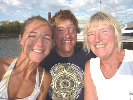
On the boat with Alice
We drove back to our campsite, and quickly got the barbecue going. We hadn’t bought any firewood this morning, as Adrian had thought that it was expensive, and now the camp store was closed. Nevertheless, we gathered up enough scraps of firewood to make a good fire, and didn’t come in until late.
Saturday 12th September Clouds as we leave Lake Tahoe 63 miles
We went to have a look at Fallen Leaf Lake before driving across the road, where there were several trails to walk. One of these followed Taylor Creek, a beautifully clear river which flows into Lake Tahoe. In one place, an underground viewing chamber allowed you to see below the river surface. Kokanee salmon come here to spawn, and also brown trout. We must have been a bit early for that, but we could see quite a lot of fish. The fish live in Lake Tahoe, but come here to spawn.
We walked on down to Lake Tahoe. Today had started surprisingly cloudy, and we had a few drops of rain here, before blue sky returned. We had some more rain in the afternoon, but all short-lived. We walked along beside the beach until we reached the site of a former estate. There had been a ‘resort’ here in the early 1900s known as Tallac. A chap known as ‘Lucky Baldwin’ had built a large casino. Gambling wasn’t allowed in California, so when the sheriff was approaching, outriders warned Baldwin, and all the gambling things were put away, so that he just saw genteel ladies enjoying themselves!
The large trees here were called Jeffreys Pine, and are similar to the ponderosa. Baldwin had prevented the trees on his land from being chopped down, as most others in the area had been, to ‘feed’ the silver mining site of Virginia City. We watched dozens of little chipmunks scampering at lightning speed, and several Steller’s jays.
It was 11.15 when we headed off around Lake Tahoe. The road was incredibly busy. We were glad not to be here tomorrow, when there is a big cycle race, so driving on the ever winding roads would be even more hazardous.
The road wound high up around Emerald Bay, a long inlet from the lake. There was a viewpoint from here, and it is where everybody comes, so it was really crowded, but luckily we managed to find a spot to stop. We had to ignore the crowds, and enjoy the beauty of it. The water certainly looked dark green, in contrast to the blue of the rest of the lake. Far below was Fanette Island – the only island in the lake. In the early 1900s, a Mrs Knight had built a tea house on top of this rocky islet! There was also a castle built by the lakeshore, called Vikingsholm Castle, which had been built at the same time.
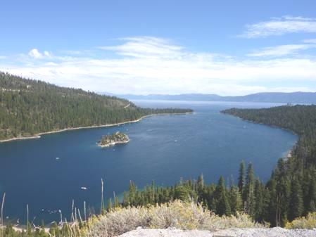
Emerald Bay on Lake Tahoe
We continued around the lake, rather frustrated that the shore was either in a State Park, or was taken up with smart residences. We finally did find a lone picnic table near the waters edge to have lunch.
At Tahoe City we left the lake – we had driven almost all the way around it – and followed the attractive Truckee River to Truckee. Here we did some shopping before continuing north through TahoeNational Forest, with its many pine trees.
We stopped to walk to the site where the Donner family pioneer group had camped in 1846. The early severe winter was disastrous for them and half of the 87 people had died.
Continuing through the forest, there were a number of small forest campsites. We stopped at 4 o’clock at one called Cold Springs. The few aspen trees amongst the pines were beginning to change colour. The little stream trickled by.
The evening became quite chilly, but we enjoyed a campfire with wood which Adrian had ‘found’, although we had bought some at Truckee. There was nobody else here, so we enjoyed the quiet and the stars.
Sunday 13th September Through forests to a National Volcanic Park 166 miles
We left early on a cool morning, stopping to have breakfast in Sierraville, where the sun shone across the golden grassy meadows. We had passed the odd sight of a photo-shoot – a couple in the middle of the field with a photographic umbrella directing the sun – strange at 7.15 on a Sunday morning in this tiny town. We received an email from Alice, but weren’t able to get a connection to phone Simon.
We continued north-westwards through mostly forested country, but with some golden grasslands with black cattle and horses. We crossed the Middle Fork of the Feather River, and thought of my great great uncle William Lawson, whose gold claim was on another branch of the Feather River.
At Quincy we stopped and put the washing into the launderette. We managed then to phone Simon. I had a disaster, when I accidentally spilled my coffee all over myself and the seat – too late to add things to the wash!
As we drove on, the scenery became really dramatic, with steep canyons, and with two railway lines crossing on viaducts and then going into tunnels.
Our route followed Indian Creek, which tumbled over lots of little waterfalls with rough, jagged rocks. We passed through several small towns, Greenville being a lovely old wild west town.
When we reached Lake Almanon we followed up the eastern side, stopping for lunch beside the lake, after the picnic area was closed. Across the lake we could see Lassen Peak, 10,457ft, which we are heading for.
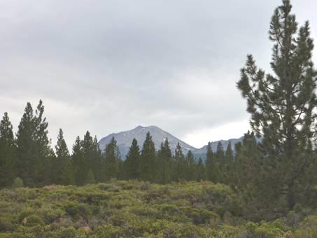
Lassen Peak
We continued, mostly through forest, stopping at a viewpoint at Hat Creek Rim, where a fire had devastated a large area a month ago. We could see Lassen Peak, which is the southern end of the Cascade Mountain Range, and 80 miles away to the north we could see Mt Shasta, which we had seen when we were in Oregon.
Now we proceeded into Lassen National Volcanic Park. The road goes for 30 miles through the park, but when we received the park brochure, we realized that there was a lot that you could do. We had known nothing about Lassen Peak, which had erupted many times around 1915, but has been dormant since.
We soon headed for Crags campsite (5,700ft) and Adrian prepared a campfire, as it seemed as though we were in for a cold night!
It was a good campfire, especially as it was all made with wood which Adrian had collected. It was really quiet, and before we came in, the skies cleared, and we could see myriads of stars up through the tall trees.
Monday 14th September Enjoying Lassen Volcanic Park 53 miles
We had a few drops of rain in the night, but were still able to have breakfast outside before leaving at 8 o’clock.
Visibility was poor today, which was a shame, when part of the reason for coming to the park was for the remarkable views, but we were still fairly lucky.
We stopped first in drizzle to walk around what was called ‘Devastated area’, where we could see rocks transported here after the violent eruptions in 1914/15. When we stopped to look at Summit Lake, we could see mist rising from the lake.
We stopped at the highest point on the road – 8512ft – which is the start of the 2½ mile trail to climb Lassen Peak, but at the moment the trail is closed half way along because of a rock fall.
We pulled in at the parking area for the walk to Bumpass’ Hell. There was a large erratic rock in front of us, brought there by a past glacier, but we couldn’t see the view much beyond. We watched mountain bluebirds as we had early tea/coffee before we set off on our walk, leaving at 10 o’clock.
The walk went uphill for the first mile, on a rough path climbing 500ft. We enjoyed what views we had, with the pretty mountain hemlock trees (John Muir’s favourite) and the colourful vegetation, including silver leaved lupin, amongst the even more colourful rocks. Little chipmunks scampered off and juncos scrabbled for seeds.
We became aware of the strong smell of sulphur, and the sound like a train letting off steam, as we began the half mile descent to the ‘hell’. This was supposedly 250ft down, but seemed much steeper than the ascent.
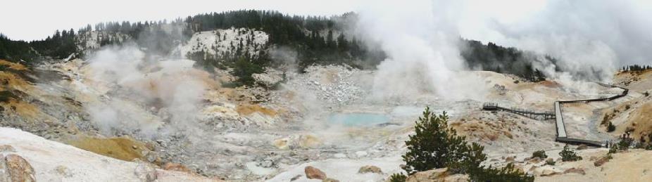
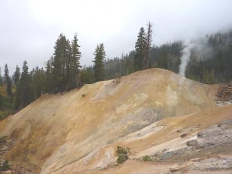
Bumpass’ Hell
We reached the boardwalk around this fantastic hydrothermal area – it was like being at Yellowstone again! Water and mud bubbled up from holes in the ground, amidst really colourful rocks. Steam hissed and water trickled over rocks. It was a real treat for all the senses! The area is named after an early guide/prospector called Bumpass, who lost his leg after inadvertently falling into the boiling mud (he had no boardwalk to stand on!) He had wanted to extract the minerals, and start up a business, but his accident put paid to that!
We started off on our return journey, with the visibility somewhat better. Just before getting back, we chatted to a couple from New Jersey, who stopped to photograph us by Helen Lake.
By Helen Lake
They had lived in Sussex for three years and had loved it, and had returned to visit this year. He had been a naval pilot, and they had just attended a reunion of his division at Reno and a flying display at Fallon.
It was midday when we returned, so we stayed with our great view, and I cooked enchiladas for lunch before we carried on with our drive south through the park, stopping when we could to enjoy the dramatic landscape.
When we reached the area known as Sulphur Works, it came on to rain, but this didn’t stop us from walking out to view more steaming holes – one had recently appeared, right by the road, so had had to be fenced off.
Fumerole at Sulphur Works
It was still raining when we reached the southern park exit, so we looked in at the newly built Visitors Centre there. We saw a short film about the park, which reinforced the fact that the park contains all four kinds of volcanoes, and that Lassen Peak is the largest plug dome volcano in the world. We were sorry not to have seen more of the peaks, but were pleased that we had diverted our route to visit this dramatic park.
We drove out of the park, continuing on a pretty and winding road south. We stopped at Potato Patch Forest campsite, beside Deer Creek at 4 o’clock. We had a walk around by the creek, and Adrian collected up some more firewood. The few deciduous trees amongst the firs were beginning to look autumnal.
Another lovely evening. Just as we were going to eat, the American /Japanese chap camping nearby – the only other people – came to chat to Adrian. We enjoyed sitting by our campfire, with the sound of the stream gushing by, and the marvellous sight of myriads of stars before we came in at 9 o’clock.
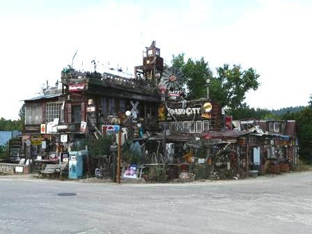
A quirky place in Idaho City
Bend, Oregon to Lassen, California


I cooked a tasty omelette for supper – it was all we could think of eating and cooking!


