
Tuesday 22nd June 2004
After 2 short months in England, we were returning to the U.S. to explore the American Rockies. The weather at home had been mostly good, and the garden had never looked lovelier. We had planned our flights so that we could attend a wonderful ‘40 years on’ reunion at Rosie’s old college in Portsmouth last week.
On Friday, Simon and Laure had left for Calgary, for Simon to take up a new job there after their year or so in Europe. We had met up with Emma and the children on Sunday to talk about last minute plans for their holiday in the Tiv this summer, then we had all enjoyed a barbecue at Paul and Nicky’s in Parbrook. Tom was in London, completing his PGCE.
It was ironical that our taxi arrived early for our 9 o’clock pick-up, when we actually had plenty of time anyway! In fact, we arrived at Savacentre early, and were able to get on the earlier bus, which was just about to leave! How different from the 2 times recently when we had missed our bus because the taxi hadn’t turned up! When we arrived at Heathrow, we were too early to book in! We filled in some time having a very expensive tea and coffee!
Although Adrian had checked our seat reservations only the other day, we were told that they were requests only, and we had been given alternative seats! This didn’t please us, of course, but I was able to change them to window seats (admittedly over the wing), just before boarding the plane.
We had spent a lot of time hanging around, looking in the posey shops, and then waiting in ‘departures’. We had been told that there might be a short delay, and finally, having received no announcement at all, we joined the other people boarding the plane. Even then, it was a long time until we actually took off, so we had to endure the heat of the cabin until we finally left 2 hours late at 15.15. We were able to see the bend of the River Thames before we ascended into cloud, on what had started as a beautiful day.
We were glad to have eaten the cheese sandwiches I had made, as ‘lunch’ was eaten after 4 o’clock! It was unremarkable, but at least we had free wine on B.A. We had had some glimpses of the icy wastes of northern Canada, but it had stayed mostly cloudy until we neared Phoenix.
We touched down at 5.00 pm local time (only 45 mins. late!) – but 1.00 a.m. to us! There was a muddle of people as we waited to collect our luggage, and then a long walk along various corridors to get out of the airport. When we finally did so, it felt as if someone had put the heating on! (102°F - 38°C). We found a taxi to take us the short distance to Ken’s Storage to collect the Bam, arriving there at 6 o’clock. But then it was dismay, as, despite Adrian speaking to Ken on the phone a few days ago, the place was all locked up with 2 large mastiffs guarding the entrance! We could see the Bam across the yard, but couldn’t get to it! Not knowing what to do, we let the taxi driver go, while we contemplated! We tried every option we could think of, including ringing the number on our mobile (no other phones nearby), hoping that it might get transferred to Ken’s home. We knew that he finished work at 5.30, but he had said that he would wait. There had been no phones in the vicinity at the airport, so we couldn’t ring from there when we landed. We tried asking at several local premises, and speaking to a couple who pulled up in a car, but finally realised that the only thing to do was to flag down a taxi (when we saw one!) and ask to be taken to a nearby hotel. At least we were hanging around in warm sunshine! We eventually got a taxi, and arrived at the ‘Best Hotel’, where we booked in to a typically uninspiring room. There was the usual barren swimming pool, but all my cozzies were in the Bam! Undeterred, I rummaged through my things and found some navy pants and a matching suntop, which sufficed so that we could have a refreshing ‘cooler’ before crawling into bed at 8.00 (4.00 am to us!)
Wednesday 23rd June 198 miles
Well, of course we didn’t sleep for long, waking first at 11.00 and then at 2 o’clock! We were up early, and I wrote yesterday’s diary on the computer. We were glad of the goodies we had brought with us, and breakfasted on cereal bars, bread, butter and cheese. There was coffee in the room, but Adrian had to make do with water to drink! We had an early swim in the pool, me wearing my make-do swimsuit again! The sun was shining, and it was already hot.
We were ready to leave at 8.30, and had a cheery taxi driver to take us back to Ken’s RV storage. We found the Bam in good shape, and were particularly pleased with the job that Ken had made of repairing the back step (he was too!) He didn’t seem to remember that we were supposed to have arrived last night! We loaded up, including some parcel post, which came in a selection of boxes much larger than needed! We filled the water tank (with water that didn’t taste too good), and left at 9.45. Initially we drove in the wrong direction for a couple of miles – not a good start! We still marvel at the enormous size of American towns, and the amount of wide roads, with nothing much along them except shops and businesses.
We soon headed out in the right direction, heading for an RV place for Adrian to buy some bits. On the way we stopped at Fry’s, where we did a huge shop. A lady had come to ask about our van, as she liked the look and size of it, as so many people do.
After Adrian had got his ‘bits’ at the RV place, we pulled into Walmart car park for Adrian to buy some small gas cylinders and a map book. At 2.15 made our way northwards on the I17 towards Flagstaff.
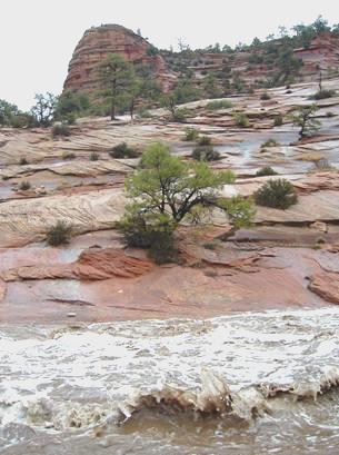
We hadn’t been going long when we passed the scene of an earlier accident. The area hadn’t been cordoned off very well, and there was almost no warning. The road was littered with various bits of debris, and at this point a stone was thrown up by a passing lorry and shattered the edge of our ‘new last trip’ windscreen! We had survived 3 months in Mexico for this to happen in our first few minutes of driving here! Adrian said a few things, and could have said much more!
We pulled briefly into ‘Sunset Point Rest Area’, which had nice views across the desert scenery, but incurred a long diversion to reach, as it was on the other carriageway! We had been enjoying seeing the cacti, but as we drove towards Flagstaff, the vegetation changed to fir trees, as we climbed to 7000ft. We drove through attractive scenery, passing near places we had visited last Autumn with the temperature now dropped to a more sensible 80°F. Before we knew it, we were in Flagstaff, and found ourselves driving through the town on ‘old Route 66’, which we well remembered from our previous visit in 2002.
From here, we followed the 89 north, passing Sunset Crater and Wupatki, which we had also visited in 2002. The scenery soon became desert-like again, with lovely vistas, but no trees, just scrubby grass tufts. We were wondering where we could stop, when we came across a waste bit of ground just off the road, which seemed just fine! It was now 5.30, and we were beginning to feel a bit weary! We busied ourselves getting sorted, surrounded by our superb desert views.
Thursday 24th June 142 miles
We had a good night’s sleep, although it became quite cool during the night. We woke just after 5 o’clock, and saw the sun rise across the desert. Trucks began arriving for the quarry further down the road. We had decided to move on and have breakfast a bit later, so at 5.30 we were on our way.
Soon after Cameron, where the road turns off to the south rim of the Grand Canyon, we stopped by a fine bridge crossing a small ravine. I was still in my nightie, and we were surprised when a group of people, including several children, walked up from a nearby car to view the bridge too!
We continued north through Navajo Indian lands, and wonderful bare mountain scenery, stopping for breakfast at about 7 o’clock, with superb canyon cliffs in the distance.
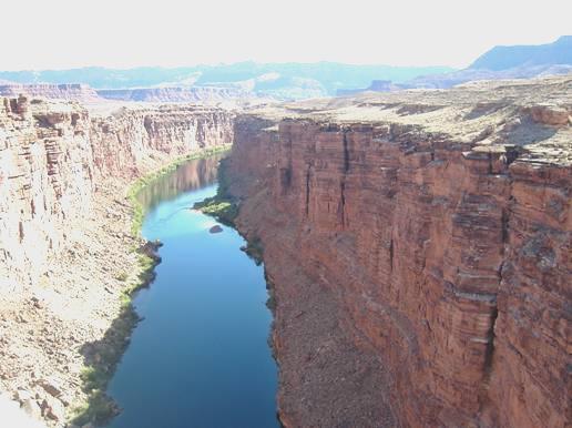
Colorado River from Navajo Bridge
Before long we came to Navajo Bridge, over the Colorado River. This bridge was built in 1928, replacing Lees Ferry, a few miles upstream. It was the only crossing of the Colorado River for 500 miles. In 1995, a second bridge was built to take heavy traffic, its design nicely complementing the first bridge. It was already extremely hot as we walked across the old bridge, enjoying the spectacular scenery, to the Visitors Centre on the northern side.
We now decided to drive the 5 miles to Lees Ferry itself. I was blown away by the staggeringly beautiful scenery all around. At Lees Ferry, we first walked down to Paria beach, where we paddled in the freezing Colorado River (before the river was dammed at Glen Canyon a few miles upstream, the river used to be warm in the summer, but the lake behind the dam is too deep to warm up now). At the boat ramp, lots of people were loading into the large rafts for organised trips along the river.
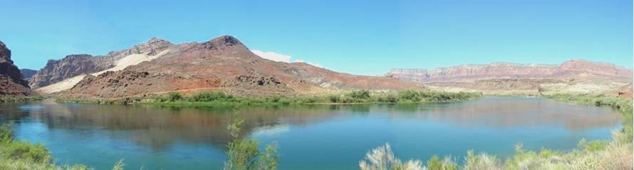
Lees ferry on the Colorado River
We opted to walk along a little trail beside the river. Although this was wonderful, I arrived back feeling extremely overheated, with a crimson red face, and dripping sweat – the temperature was now over 100°F (38°C). We drove a short distance to the start of a trail to Lonely Dell Ranch, where the ferry operating families had made a home in the 1800s. I had wanted to walk to the ranch, but Adrian thought it not a good idea. However, when I saw that it was only 200 yards, I decided that I could make it. It was inspiring to see how the people had made a go of it in this remote spot with its extreme heat and lack of rain. I enjoyed seeing the wooden huts, the orchards that had been planted, along with trees for shade.
Now it was time to move on, so we drove back the 5 miles to Navajo Bridge, stopping to view some attractive ‘balancing rocks’.
We continued on the road to the north rim of the canyon, passing places with names like ‘Vermillion Cliffs’ and ‘Cliff Dwellers’. Here there were more strangely shaped rocks, some added to with large blocks of stone to form primitive dwellings. We walked around these strange rock formations. The weather now had changed somewhat. There were large grey clouds, with odd bursts of thunder and dramatic streaks of lightning, but only one or two drops of rain.
As we continued on our way, the road began to rise. We stopped at a viewpoint down to the plain below, and soon after this, we were driving through trees – small at first, then gradually bigger, until at 7000ft, it was forests of ponderosa pines. When we reached the turnoff to the Grand Canyon, we stopped at the Kaibab Forest information place. While we were in there it really did rain, with huge drops. We found out that you could camp in the forest for free, so this is what we did, turning off after a few miles to a remote spot amongst the tall trees. It was only 3 o’clock, but the campsite in the Grand Canyon was full, so we intend to visit early tomorrow. We spent some time looking through our various leaflets before walking out into our ‘private’ forest, which was disappointingly lacking in wildlife, but had the delightful damp smell of woods after the rain. Although not cold, it was far cooler than this morning!
Friday 25th June 106 miles
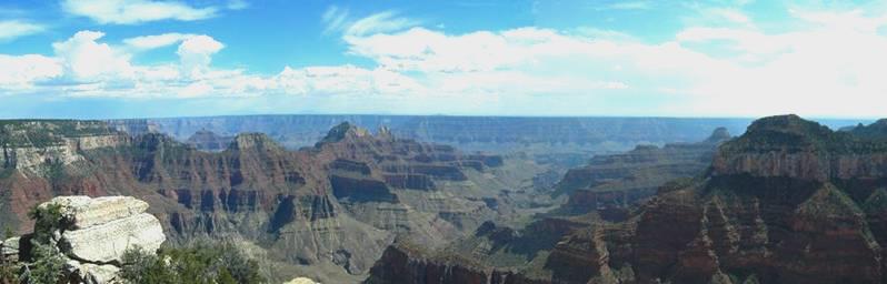
A brilliant day spent at the North Rim of the Grand Canyon!
The night had been cool, but not cold. We woke early, and left at 6.15, having seen nobody since our arrival at 3 o’clock yesterday!
As we drove down towards Grand Canyon National Park on the fine, recently tarmacked road, we passed only a couple of cars, but we did see 2 solitary deer beside the road, and lupins growing under the trees.
There was nobody at the entrance booth to the park, and we could drive straight in (we had spent some time last night trying to find out what time the park opened!). Soon afterwards, we saw a whole group of deer at the edge of one of the meadows. We also saw the first of many tiny little ground squirrels, and later we saw what must have been a condor.
We headed first for Point Imperial, catching one or two glimpses of the canyon on the way. We reached Point Imperial at 7.30, and like on our visit to the South Rim 2 years ago, our first sight of the canyon took my breath away. There was no-one else around, just the sound of birds, and even a little hummingbird as we arrived. I felt that even if we saw nothing else, this whole trip would have been worth it! It was misty, and partly cloudy, but I was overcome by the beauty.
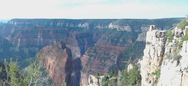
Point Imperial, Grand Canyon
As we walked back to the Bam, other people began to arrive – most noticeably a coach load of children, and a few adults, all dressed in puritan type clothes. The girls wore pretty long dresses, and wore their hair in an old fashioned way. The boys and men wore jeans and check shirts. Some of the adults began preparing breakfast at the picnic site opposite, while the children ran around excitedly. We thought that they were probably Memonites, or possibly Mormons. One young boy liked my binoculars. I let him look through them, and he asked if he could have them!
We came back to the Bam for a right royal breakfast of cereal with strawberries, followed by bacon, egg and mushrooms – and with our wonderful view as a bonus. We walked out for one last beautiful view before we left at 9 o’clock, by which time it was really warm and sunny.
We now drove back the 5 miles to take the road south, stopping soon at Vista Encantada, where, as well as the lovely views, we photographed a swallowtail butterfly. A bit further on was Roosevelt Point, named after Theodore Roosevelt, who played such a key role in setting up the National Parks in America. Here we met 2 very pleasant French Canadian couples from Montreal. After chatting to them, we walked the short trail, with more lovely views. There was the sound of thunder as we left, but it didn’t materialise to anything.
Some miles further on, we stopped at Walhalla Overlook. Apart from more spectacular views, there were ruins here of pueblo buildings from 1000 years ago. The Indians spent the summer up here, growing crops, and the winters down in the canyon, avoiding the freezing temperatures. By now it was really hot. We sat on rocks, with what little shade we could find, to have our coffee
Walhalla Overlook, Grand Canyon
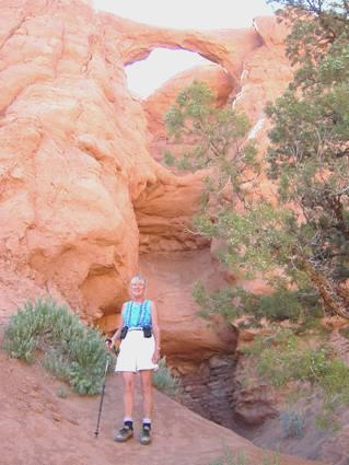
It was now 11 o’clock. We drove on to the trail to Cape Royal, which passed the natural rock arch known, understandably, as Angels Window. To reach this, we had to walk out on a narrow path above the natural arch below. The views, of course, were magical, and I was pretty brave! It was still misty, but from Cape Royal, we could just make out the tower on the South Rim.
We drove back now, stopping at Encantada for lunch, sitting at a picnic table, in the shade, and with views, just about, through the trees to the canyon. A deer came to visit, which added to our enjoyment. We drove on, stopping by Greenland Lake. This was almost dry, but it was pleasant and peaceful. We walked on to a little hut, and on our return Adrian spoke to 2 teachers from Houston, who marvelled at our lifestyle. The man hated heights even more than I do!
Now we had to take the road back, and on round towards Bright Angel Point, stopping to get some necessary, but expensive, fuel on the way.
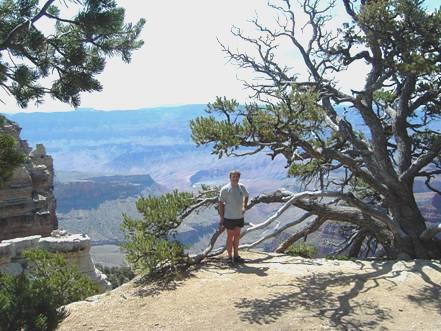
Bright Angel Point is where the Visitors Centre and the accommodation is, and it was pretty busy. The trail out to the viewpoint was a narrow path along a ridge – rather scary for me! It amazed us here,and elsewhere in the park, that there were no railings, or anything to stop you falling the thousands of feet into the canyon below! We were glad not to have any children with us! The views, of course, were great. We could see to the Bright Angel trail on the South Rim, and had vistas all around.
View from Bright Angel Point
We walked one last trail – part of the Kaibab Trail, which goes right down into the canyon and joins with the Bright Angel Trail, for the really energetic! (it drops 6000 ft). We walked down the sandy track for about twenty minutes, knowing that we then had to walk back up again! By now the sun had gone in, so it was a pleasant temperature, but this track was used as a mule trail, and we hadn’t realised how strongly mule poo smelt!
By 5 o’clock we were back at the Bam, and it was time to head out of the park. It was about 5.30 as we drove out of the park, and into the Kaibab National Forest again. We drove for a few miles before turning off onto a track, and finding a place to spend the night, as the rain tried to fall, but didn’t amount to anything. It had been a wonderful day.
Saturday 26th June Happy Birthday Sara 166 miles
The night had been cool but we were awake early and left at 6.30. We drove a few miles along the road (I actually drove!), and stopped for breakfast in the sunshine beside one of the meadows. We drove on to Jacobs Lake, then westwards, stopping at 8 o’clock at a viewpoint to the superb red and white cliffs (two separate ridges). We then began descending, and came down to desert, with no trees again, just scrub. It made us think of South Africa, but there was no wildlife – we expected to see zebras or giraffes!
As we left Fredonia, we passed ‘Steamboat Mountain’, a rock formation which did look a bit like a boat. We continued to Pipe Spring National Monument, the home of former pioneer settlers. The house here – very substantial for this remote area, had been named Winsor castle (no d!), after its former owner – Anson Winsor. We had to have a guided tour of the house, but could wander around the rest of the area. There were several rangers acting as guides, with horses, cattle and an orchard. We stopped by a lady guide, who had been born locally, and made our own tallow candles with her. She was dressed in period costume. We asked about the people we had seen yesterday at the Grand Canyon, and it would appear that they might be Fundamentalists – an offshoot of the Mormons, who still practise polygamy.
There was a new and comprehensive museum about the Paiute Indians who lived here, and the Mormons, who settled. The rangers had found a rattlesnake this morning, which was in box at the entrance, so everyone was being a bit wary!
Pipe Springs
It was a nice visit. We found out that the ‘Arizona Strip’ that we kept reading about, was the area of Arizona north of the Grand Canyon.
After a few more miles we came into Utah, a new state for us. The desert scenery was wonderful. We pulled in to have lunch – we had moved on an hour, to a more sensible time. Storm clouds gathered and it became very windy. We descended to aptly named Hurricane, and left at 2.30 (now 3.30). At neighbouring La Verkin we saw a ‘farmers market’ store, and as we needed some fresh supplies, we stopped. We now set off on the Kolob Terrace Road, part of Zion National Park. We drove through dramatic scenery for several miles, until we came out to a plateau. We now returned and descended to Virgin and soon afterwards came to a free camping spot near the river. It made us think of Oz, even down to the flies, but these flies bit! It was 6.15 new time, and still very warm.
Sunday 27th June 10 miles
We were awake at 7 o’clock and left before 7.30. We drove the few miles to Zion National Park and found that we could camp in the campsite. Having found a spot to camp, we walked the short distance to the visitors centre and caught the shuttle bus. We alighted at Zion Lodge, ready to walk the Emerald Pools Trail. We took the easy Lower Emerald Pool trail at first, and joined the many others walking this route. Having viewed the pretty spray falls here, we continued to the Upper pool.
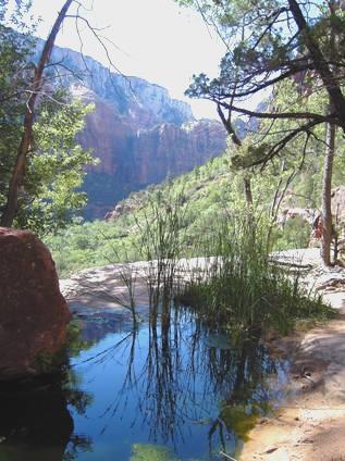
Middle Pool, Zion
We passed the Middle pool on the way. The path to the Upper pool was steep and rugged, but it was a pleasant place to stop when we got there. There was a pool (smaller than usual), containing lots of large tadpoles beneath the steep cliffs and there were several swallowtail butterflies flying around. After resting for a while, we made our way to the Kayenta trail back to the river. From here we walked back along beside the river to the lodge.
We were able to get some more drinking water here, before getting the crowded shuttle bus to the end of the route in order to walk the Riverside Trail. We had passed climbers and walkers high on the vertical rocks – it wouldn’t do for me! There was a ‘Johnny Knowall’ American sitting behind us on the bus who spoke to us as we got off. He was with his tall, blonde, Russian wife (wearing her very short shorts), who he had met via the internet.
We sat by the stream and ate our lunch and watched the many young people paddling in the river. We waited until we got to the end of the trail before I took off my walking boots and paddled. Many families were enjoying the water here, but it actually began to rain as we set off on our return walk at 1.30.
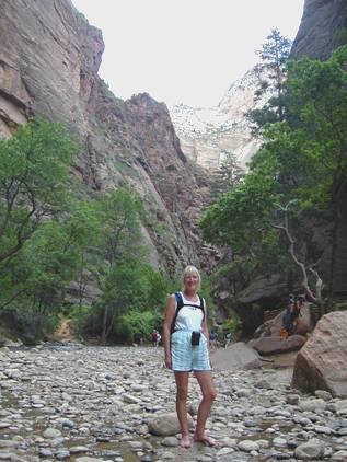
Riverside Trail, Zion
On the way back, we talked to a passing couple who came from Abingdon. At 2.30, we caught the bus back, getting off at Big Bend, as the driver had said that there was a trail from here back to the next point. We managed to find our way down a rough path towards the river, but then heaven became hell as we were bombarded by a load of biting flies. We were covered in them, and tried to run, but it made no difference. Adrian was shouting at me, and hitting at the flies – it was a desperate situation. We saw a steep rough path upwards, and scrambled up it – I would never normally have contemplated such a path! It wasn’t far back to the bus stop, so we awaited the arrival of the next bus as we recovered!
We stopped next at Weeping Rock, and walked the short but steep trail to a Wave Rock look alike with water spraying out from it, and golden columbine (a pretty yellow aquilegia) growing beside it. The sun now came out again as, at 3.15 we took the bus one more stop to the Court of Patriarchs – a very short but steep path to view 3 immense rock formations across the valley.
We now took the bus to the museum where rain once again threatened to return, so after looking around we caught yet another bus back to the Visitors Centre. We had intended to visit this, but didn’t get any further than looking at the information boards outside, as we once more came across the couple from Abingdon, Steve and Ruth. We had passed them again on our return trip, but they had got on to the other half of the bus. We got chatting again, and invited them back to the Bam for a cup of tea. They were staying at an RV park in Springdale, the neighbouring ‘town’, as like us, they hadn’t expected there to be any room in the park campsite. Also like us, they hated organised RV parks, so were reluctant to leave us and go back. They didn’t leave until 7.30, by which time we lit the Barbie (for the first time this trip) and enjoyed sitting out in this pleasant temperature
Monday 28th June 66 miles
We were awake at 7 o’clock to hear the wind blowing, and there was actually some rain. Nevertheless, we set off soon after 8 o’clock to walk the Watchman Trail. This trail is named after a huge mountain up behind where we are camping, and we found ourselves climbing steeply for about an hour. It was a pleasant temperature for walking, but was certainly a bit of a puff! At the top of the bluff we had climbed, we went on a circular trek before descending again. On the way down we spoke to a ranger, an older gentleman, who was tidying the path in readiness for next weekend – July 4th- which he said would be really busy.
We called in briefly at the Visitors Centre, which we hadn’t got to yesterday, and arrived back at the campsite at about 10.30. We needed to get some more water so that we could both have a shower, and while we were off doing this, the rangers had been along and removed our barbecue, thinking that we had left. They had actually thrown it into one of the huge, empty rubbish bins, so Adrian had to climb into it to retrieve it!
We now ascended by several hairpins to the tunnel, which is on the road we are taking. This mile long tunnel, built in the twenties, is very narrow, so RVs have to pay a $10 fee, and supposedly be escorted through. What this actually means is that a ranger at either end controls the traffic, rather like a traffic light. This went very smoothly – we didn’t have to wait – and when we emerged at the other end, we saw several people parked, and realised that this was the start of a trail with a view of Zion Canyon. We deliberated about whether to walk it, and as it was rather showery again, we decided to have lunch first. We then started to get ready for the walk, when the rain really began to fall. It fell like nothing we have seen this trip, and the whole sky became grey. We abandoned the walk idea, and drove off, but the rain became so torrential that we pulled in beside the road. The scenery was stunning – huge rock formations made of great slabs of rock. After a while, streams began pouring off the rocks, and waterfalls emerged everywhere. We got ourselves in a position where we could watch what was happening, and as the rain eased up, we ventured out. As we walked towards a high waterfall, it suddenly grew before our eyes and became thick and brown. Adrian went to video it and then walked down to the newly formed stream below. As he walked along the little stream, a gushing flash flood nearly enveloped him. The stream became larger and larger, turbulently carrying any rocks in the way. It reminded us of one we had experienced in Namibia. Other people had gathered, and we shared a bit of camaraderie before returning to the Bam. It looked extremely clean – this morning I was pleased to have cleaned some of the back of it while Adrian was filling with water, but now the whole van had been cleaned of its thick dust!
Flash Flood at Zion
We continued on our way, and stopped by what is called Checkerboard Mesa, a huge lump of rock covered with even more scoured out lines than the others. By now the sun was shining, and the stream was back to its normal size! We were now leaving Zion National Park, and drove on through rather ordinary scenery at first, but then it became pretty but less dramatic than Zion.
At Mt Carmel we turned north, driving through green and forested country. At Long Valley we turned left and soon came into Dixie National forest. It seemed rather alpine, as we passed pretty streams and a pond but then piles of black lava! Flowers were growing beside the road, some deep blue, others red, looking stunning against the dark lava. We saw a sign saying ‘lava beds’, so turned off onto the rough track. The track became increasingly rougher, so eventually we stopped. We could now see the vast black beds ahead of us, across a meadow of saltbush. We decided to walk across to the lava. The sun was warm, but the air cool, (we are at about 10,000 ft). We reached the lava beds, which were quite impressive, but were also made pretty by the amount of wild flowers growing at the edge, particularly large white aquilegias and there were also tiny blue/mauve michaelmas daises. We could hear bird song in the tall trees, and it was very peaceful. We walked back along the track to the Bam, and drove a short distance back to a clearing in the woods, which we thought would make a nice stop for tonight. It was now 5.40.
Tuesday 29th June 64 miles
The night was cool, as we had imagined it might be at this height, and we heard some rain towards morning, but woke to a blue sky. We drove back to the road, and soon passed Navajo Lake. We stopped for breakfast just afterwards beside a meadow, reminding us of Kaibab forest. Lots of little birds were in the small aspen trees beside us. We left here at 8.15 and drove into Cedar Breaks National Monument. We had trouble finding our National Parks pass, but eventually found it in the rucsac! We walked to the viewpoint, and saw the staggering rock formations making up the ‘amphitheatre’.
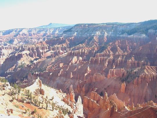
Cedar Breaks National Monument
Although sunny, it was freezing! (We were at over 10,000 feet.) We went into the little Visitors Centre and were able to view the scene from a warmer place. We now drove along to Chessman RidgeOverlook, where we could see the amphitheatre from a different perspective before setting off on a trail through the trees to an Alpine pond. We had views to the canyon through the trees, and enjoyed the myriad wildflowers which this area is known for – mountain bluebells (a type of borage), lupins, paintbrush and many, many more. There were also bristlecone trees, said to be over 1,000 years old. The sad thing was that there had been a beetle epidemic, and hundreds of the fir trees here had died. The notable thing for us was that we found ourselves very short of breath because of the altitude.
Back at the Bam we drove on to North View, where we had yet another superb view of the brilliantly coloured rock formations. We left the park and drove back into Dixie National Forest. The road descended to Panguitch Lake which we didn’t appreciate fully, as by now it began to rain/sleet/hail! It seemed just the time to cook bacon pancakes for lunch, and these we really enjoyed. As soon as the rain eased off, people arrived by the lake to fish! Most got back into their cars when the rain came again! We watched a white pelican by the lake – we had only seen brown ones in America before.
As we drove along the road, we passed a group of deer. We came to the pleasant little town of Panguitch and got some petrol and later some propane. We located the Post Office and bought some stamps. The lady was flummoxed as she had no 50 cent stamps for Canada, and didn’t know what to do! She finally managed to make up the value!
We left Panguitch and soon drove through Red Canyon. Red cliffs and strange rock formations lined the road, but sadly it had come on to rain. We went into a brand new Visitors Centre, where the man said that they loved the rain as they had had 5 years of drought. We weren’t so keen! We picked up some more leaflets, and had a rethink about our itinerary as we set off to find a free camping spot in the forest. We found a delightful spot, surrounded by hundreds of different wild flowers. The sun now shone, so we sat outside for our cup of tea before wandering out for a pleasant walk. We could see pink cliffs lit up by the sun in the distance. We arrived back at the Bam at 5.30, having found our way ‘cross country’ after leaving the track. There was a lot of wood nearby, so Adrian lit a fire.
An unexpectedly magical evening followed. We sat out around the fire until gone 10.00.
Campfire near Red Ruby
The almost full moon was shining through the thin cloud, and as we came in, we could just see the plough up in the sky. Heaven!
Wednesday 30th June 45 miles
The night was cold, but we awoke to sun, and enjoyed breakfast sitting outside in our lovely surroundings. We were surprised to see that a car had come in and people had put up a tent, but they left before we did. I looked up the bird we had heard last night and found out that it was a ‘poor will’, the western form of the ‘whip or will.’
We left at 8.30 and headed for Bryce Canyon. We made our way to the ‘Sunset campsite’ and booked in - by now it was 9.30. We decided first to drive down to Rainbow Point, the furthest point in the park, about 18 miles away. They were rebuilding the road, so at one point we had to wait for the pilot car. We stopped off at most of the viewpoints on the way – at the first we saw some nuthatches climbing up the trees. We liked the rock arch at Natural Bridge, but of course the thing you come to see here is the fantastic rock formations, including ‘the hoodoos’, in their myriad of colours.
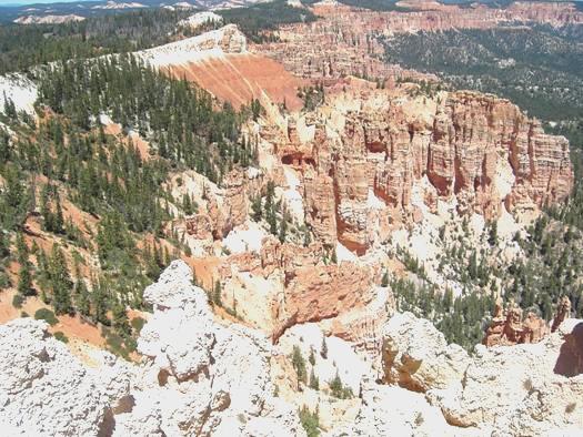
From Rainbow Point Bryce Canyon
At Rainbow Point we had coffee sitting outside in the sunshine before walking on the mile long Bristlecone Trail. Apart from the ancient bristlecone trees, like we had seen yesterday, we had some wonderful views of the canyon, and across the Utah plateau to Navajo Mountain. We walked on to Yovimpa point, then came back to have lunch, sitting at the same picnic table.
We now drove the 18 miles back to the campsite, and got ready to leave for a walk. It was 2.30 by now. We walked to Sunset Point for the start of the Navajo Trail. This was the most amazing walk we have ever done. The path hair-pinned down about 30 times through wonderful red rock formations. Somehow, huge Douglas fir trees had established themselves in this soil-less environment. Against the blue sky it was stunning. We were annoyed that a noisy coach party had arrived just as we set off, but we were soon in peace and solitude, with just a few passing people to chat to. The walk we were doing joined with one called the Queens garden – the Queen being Victoria, as one of the hoodoos certainly resembled her.
‘Queens Garden’, Bryce Canyon
Then of course we had to ascend from the canyon, but the walk had been fantastic. We arrived at Sunrise Point at 4.30. We walked back to the campsite. It was now 5.30, so Adrian lit the barbie and after supper we decided to walk back up to view the canyon from Sunset Point. The sun had already gone down behind the trees, so was not shining on the canyon, but the almost full moon was up, and we joined the other groups of people quietly enjoying this wonderful spectacle. It made us think of Broome beach in Australia, where everyone comes to view the sunset.
It was absolutely beautiful. Bryce will stay with us as a favourite place. We quietly walked back to the campsite. It had been a great day.
Thursday 1st July 40 miles
We were up before 6.00 am as we wanted to be at Sunrise Point to watch the sunrise. Several other ‘daft’ people had gathered there, with cameras of varying types, and all were quiet until some noisy Germans arrived! It was very cool at this hour, but there was a magic feel to being there, and it was lovely to see the different lighting on the rock formations. An extra delight was seeing several deer, including 2 young ones, on our way. We left here and drove to ‘Inspiration Point’ and then on to ‘Bryce Point’, getting more magical views of the wonder spread out below us.
Bryce Canyon from Sunrise Point
Now we returned to the Sunrise Point area where we breakfasted outside in the increasingly warm sunshine. We drove back to the Visitors Centre, where I was able to post the cards I had written. Also, we spoke on the phone to Emma and the children, as Felix had had his 4th birthday party today. Afterwards we phoned Tom, whose PGCE course finishes tomorrow.
After looking out from one more viewpoint, the road left the park, but soon came back into it again, and in this section we walked one last trail. This was called the Mossy Cave Trail, and followed a clear stream through barren orange/red rock to a little waterfall and a cave. There were still strangely shaped rock formations, with ‘windows’ showing the unreal bright blue sky beyond.
We turned off at Cannonville as we wanted to visit Kodachrome State park. Cannonville was a tiny, sleepy ‘town’, but had a shady picnic area under a weeping willow tree, in the middle of this desert scenery. This was just the place for us to have our lunch. We now continued the 9 miles to the park, and drove on through to the campsite. Although nothing could match nearby Bryce Canyon, this place was pretty impressive, with ‘statues’ of white rock on beds of red cliffs. The sky was still an uncanny blue. After finding a spot to stay, we set off to walk the ‘Panorama Trail’, stopping first briefly at the little ‘shop’ and buying some steak from the friendly lady.
Kodachrome Basin State Park
Our walk was very hot, but we often had a pleasant breeze. The dark green of the trees added to the colours. We passed no other people at all, just a few birds, including some chukars – a type of colourful partridge- and their young. We arrived back at 4.45, feeling very hot, but Adrian still went to get some firewood for later. We cooked the steak, which was better than we had expected, then set off to walk another trail. This one was called the Angel’s Palace, for some reason. It was more of a climb than we had imagined, but again we met no other people. We came back and lit the fire again, and waited for the full moon to come up above the mountains. It was now 10 o’clock, and very quiet.
Friday 2nd July 54 miles
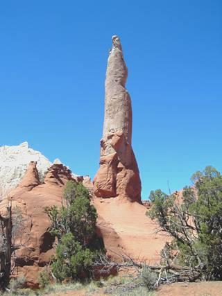
We were up late today, waiting for the sun to come up over the mountain. We left at 10 o’clock and drove for a couple of miles on a dirt road to walk the Shakespeare Arch Trail. This short walk was again very undulating. There were fine views over the multicoloured landscape, and the walk culminated at a high rock arch, named after the park manager who discovered it in 1976. We returned to the Bam, and had coffee sitting under the shade of an old juniper tree.
Shakespeare Arch
As we left the park, we passed 2 cowboys on horseback, herding their cows along the road. We drove the 9 miles back to Cannonville, where we rejoined the ‘Scenic Route 12’. We stopped once or twice along this pretty road before pulling into Escalante Petrified Forest State Park. Having paid our fee (with difficulty, as we had no change again), we had lunch sitting at one of the campsite picnic tables, looking down to the reservoir. It was hot, but very windy. We now set off to walk the Petrified Forest trail. This was supposedly only a mile long, but I think that their measurements must be different from mine! It began by climbing up and up the cliffs (luckily I remembered my hiking stick!) We had good views down to the lake. Along the top of the trail we walked past some pieces of petrified wood. Having visited the National Petrified Forest in Arizona, we weren’t too impressed. There was an extra trail we could have walked, which contained more petrified wood, but that was supposed to be even steeper and more strenuous, and our walk was enough for us!
When we returned to the bottom, we had a refreshing swim in the lake before leaving the park.
We drove on through the tiny town of Escalante (800 inhabitants), and bought a few things in the shop there. A few miles further on, we turned off on the ‘Hole in the Rock road’, an old Mormon Pioneer track. We found a nice place to stop for the night, under the shade of a large juniper tree.
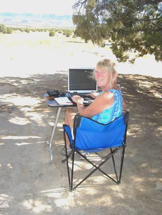
Writing the diary
While I wrote up the diary outside, Adrian fixed a new lockable water inlet. We ate supper, sitting out in our seclusion. It was very quiet and warm. We sat out until 9.30, then came out again at bedtime to see the full moon. A top spot.
Saturday 3rd July Happy birthday Emma! 93 miles
After a good sleep, we awoke to find the sun shining in. We left our lovely spot at 8.45 and continued on Scenic byway 12, through more dramatic scenery. We passed through vast areas of slickrock, where flash floods occur as the rain cannot penetrate the hard, soilless rock.
It looked rather like moonscape.
We pulled into Calf Creek recreation area, but decided against walking the 3 miles to a waterfall, and continued on our way, across the Hogsback. This was a high, narrow ridge above the surrounding remote, barren wilderness.
We drove through the tiny town of Boulder (250 inhabitants), but didn’t visit the museum here of a partly excavated Indian village. We now began ascending Boulder Mountain, and were back in Dixie National Forest. It was very green and pretty, with wildflowers wherever we looked. We pulled into Homestead viewpoint with wonderful views as far as Navajo Mountain, and we could just make out what we thought was Monument Valley in the distance. A little ground squirrel kept us amused.
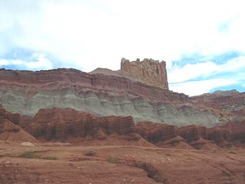
We stopped at one or two more viewpoints before we reached the end of scenic byway 12 at Torrey. We now drove into Capitol Reef National Park. This was another area of staggering scenery. This time the predominant rock colour is red, but there are also huge mountains of yellow. The park follows the long ridge (the reef), so is very long and thin.
‘The Castle’ Capitol Reef
We stopped by several viewpoints beside the road before turning off to the campsite. Having found ourselves a place here, we had lunch, sitting outside at the picnic table. It was warm and windy, and we could see that there had been heavy rain recently.
We were surrounded by orchards, as this had been a Mormon settlement. Later we ate some apricots, which were delicious.
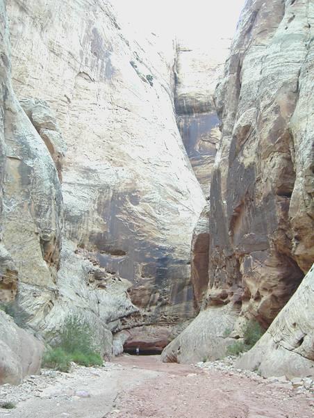
We now set off to drive the 10 miles of the ‘Scenic Road’ through the park. At the far end we started walking the Capitol Canyon trail, when we thought it more sensible to drive along the dirt track, so returned to the Bam. After driving the 3 miles or so, we now set off to walk again. The walk was along the riverbed between high steep canyon walls. A little way along there were petroglyphs on the rocks, and further on there were the inscriptions of the early pioneers, but we missed seeing these on the way down.
We were supposed to see some tanks (holes in the rock which held water), but these were off the track, and a climb up the rocks, so we gave them a miss. We continued walking for some way along the narrow canyon before we realised that we were walking too far, so set off on our hot return walk. It was 4.50 when we reached the Bam again to drive off back towards the campsite.
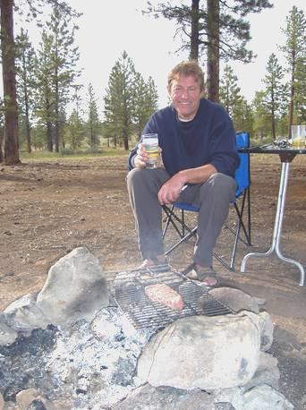
We drove down the track to the Grand Wash, but didn’t do any more walking until we arrived back at 5.40 and walked around the camping area before Adrian lit the barbecue.
We ate supper, then hurriedly made our way over to the ‘amphitheatre’, where a chap called Scott August was playing and talking about Indian flutes. We had heard him briefly at Bryce Canyon Visitors Centre. He visits the National Parks of the South West, playing at different ones in turn. He certainly had a passion for his music, and it was moving to see so many people, lots with young children, sitting out silently under the night sky. A few bats flew overhead, as the light left the sky. He didn’t finish until 9.15, and we then sat out for a while longer, with the light of the candle we had made at Pipe Springs, not wanting to lose the magic. The stars were wonderful, but the moon still hadn’t come above the rocks at bedtime.
Sunday 4th July Happy 4th Birthday to Felix! 61 miles
We got up at 7 o’clock and walked along beside the Fremont River and back before breakfast. This we ate outside, and included some apricots from the orchard.
We drove back up to the Visitors Centre as we wanted to phone Felix to say Happy Birthday. We spoke to him, and to Ruby and Emma, who was busy getting ready to leave tomorrow for their trip to France in the Tiv.
Along the road, we stopped at the tiny old Mormon schoolhouse – we had been too early to visit the Blacksmith’s shop and the Homestead, as they didn’t open until 10.00. Along from here were some morepetroglyphs – the first lot were quite easy to see, but a long walkway had been built to some others, which were hardly visible. We met 2 chaps from New Zealand, one of whom now lives in San Francisco.
We drove on a bit to the start of the Hickman Bridge Trail. We set off at 11 o’clock to walk the mile or so uphill trail to a rock arch set high in the mountainside. It was a pleasant walk, with views to Capitol Dome, named as it looks like the shape of the capitol building in Washington. We spoke to a couple from Torrey who reminded us that it is the final of Wimbledon today. They said that this was their favourite National Park as it doesn’t get many visitors – we chose well for 4th July! She made me think of Australian Lyn.
It was now 12.30 so after Adrian had cooled his feet in the river, we drove on past the picnic area, which had a few tables set across tall, rough grass, but right in the sun. We stopped at the end of theGrand Wash trail – the other end from yesterday.
We left at 1.30 to walk part of this trail, which followed up the riverbed between enormously high rocks faces. It had become quite cloudy, so wasn’t too hot. We spoke to an older couple from California. He said that he had walked to the Cassidy Arch from the campsite yesterday – a return distance of 9 miles over very rough terrain. We realised that it was his wife who we had seen anxiously waiting at the end of the trail last night.
Find Adrian in the Grand Wash
It was 2.45 when we reached the Bam again, and set off to leave the park. Before we did so, we saw several cars parked, and could see that there was a waterfall, and some families enjoying the river below. We joined them for a while, and cooled our feet in the muddy Fremont River. It was nice that we had just seen ordinary families quietly having fun over this holiday weekend. Not one person said ‘Happy 4th’!
As we left the park, we once more came to barren moonscape scenery – miles and miles of it. The rocks were of different colours, but it had a God forsaken feel – the only green was the occasional bit by the water.
At Hanksville we tried the BLM Information place, but it was closed, as we had expected. We went into a store by the petrol station, but only succeeded in buying beer and crisps!
We continued south in the direction of Lake Powell, and noticed that almost every vehicle was towing a boat. After about 20 miles, we turned off and found a place to stop for the night, surrounded by barren desert.
It was now 5.30 I cooked a bacon omelette for supper, which we ate inside, but then thought that we should be sitting out, so went outside for cheese and biscuits, the cheese brought from England.
In the desert, with the only spot of green
Storms were raging all around, but luckily didn’t reach us.
Phoenix to Lake Powell


